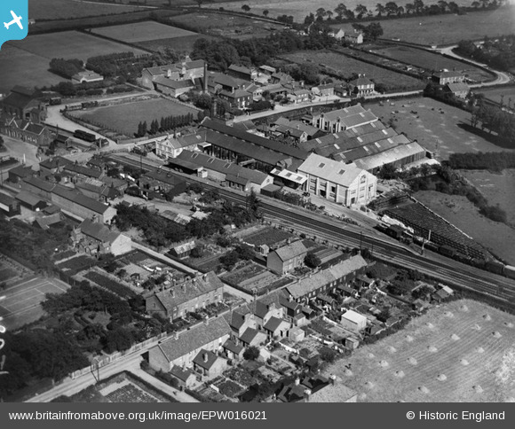
EPW016021 ENGLAND (1926). Gaymers Cider Works, Attleborough, 1926
© Copyright OpenStreetMap contributors and licensed by the OpenStreetMap Foundation. 2025. Cartography is licensed as CC BY-SA.
Nearby Images (14)
Details
| Title | [EPW016021] Gaymers Cider Works, Attleborough, 1926 |
| Reference | EPW016021 |
| Date | 1-July-1926 |
| Link | |
| Place name | ATTLEBOROUGH |
| Parish | ATTLEBOROUGH |
| District | |
| Country | ENGLAND |
| Easting / Northing | 605084, 294935 |
| Longitude / Latitude | 1.0227010596395, 52.513288653287 |
| National Grid Reference | TM051949 |


![[EPW016021] Gaymers Cider Works, Attleborough, 1926](http://britainfromabove.org.uk/sites/all/libraries/aerofilms-images/public/100x100/EPW/016/EPW016021.jpg)
![[EPW016027] Gaymers Cider Works, Attleborough, 1926](http://britainfromabove.org.uk/sites/all/libraries/aerofilms-images/public/100x100/EPW/016/EPW016027.jpg)
![[EPW016025] Gaymers Cider Works, Attleborough, 1926](http://britainfromabove.org.uk/sites/all/libraries/aerofilms-images/public/100x100/EPW/016/EPW016025.jpg)
![[EPW039235] Attleborough Railway Station and Gaymer's Cider Works, Attleborough, 1932](http://britainfromabove.org.uk/sites/all/libraries/aerofilms-images/public/100x100/EPW/039/EPW039235.jpg)
![[EPW016019] Gaymers Cider Works, Attleborough, 1926](http://britainfromabove.org.uk/sites/all/libraries/aerofilms-images/public/100x100/EPW/016/EPW016019.jpg)
![[EPW016024] Gaymers Cider Works, Attleborough, 1926](http://britainfromabove.org.uk/sites/all/libraries/aerofilms-images/public/100x100/EPW/016/EPW016024.jpg)
![[EPW016026] Gaymers Cider Works, Attleborough, 1926](http://britainfromabove.org.uk/sites/all/libraries/aerofilms-images/public/100x100/EPW/016/EPW016026.jpg)
![[EPW016020] Gaymers Cider Works, Attleborough, 1926](http://britainfromabove.org.uk/sites/all/libraries/aerofilms-images/public/100x100/EPW/016/EPW016020.jpg)
![[EPW039231] Gaymer's Cider Works and Attleborough Railway Station, Attleborough, 1932](http://britainfromabove.org.uk/sites/all/libraries/aerofilms-images/public/100x100/EPW/039/EPW039231.jpg)
![[EPW039230] Gaymer's Cider Works and Attleborough Railway Station, Attleborough, 1932](http://britainfromabove.org.uk/sites/all/libraries/aerofilms-images/public/100x100/EPW/039/EPW039230.jpg)
![[EPW016028] Gaymers Cider Works, Attleborough, 1926](http://britainfromabove.org.uk/sites/all/libraries/aerofilms-images/public/100x100/EPW/016/EPW016028.jpg)
![[EPW039229] Gaymer's Cider Works and Attleborough Railway Station, Attleborough, 1932](http://britainfromabove.org.uk/sites/all/libraries/aerofilms-images/public/100x100/EPW/039/EPW039229.jpg)
![[EPW016023] Gaymers Cider Works, Attleborough, 1926](http://britainfromabove.org.uk/sites/all/libraries/aerofilms-images/public/100x100/EPW/016/EPW016023.jpg)
![[EPW016022] Gaymers Cider Works, Attleborough, 1926](http://britainfromabove.org.uk/sites/all/libraries/aerofilms-images/public/100x100/EPW/016/EPW016022.jpg)

