
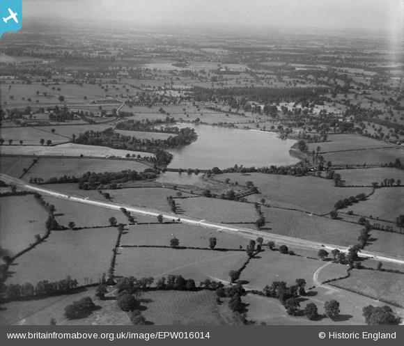
EPW016014 ENGLAND (1926). The Aldenham Reservoir, Elstree, from the south, 1926
© Copyright OpenStreetMap contributors and licensed by the OpenStreetMap Foundation. 2026. Cartography is licensed as CC BY-SA.
Nearby Images (18)
EPW016014

EAW043869

EAW048431

EAW048431
EAW044163

EAW043870

EAW043867

EPW053034

EAW044159

EAW048432

EAW048432
EAW043875

EAW044161

EAW023647

EAW044156

EAW044164

EAW044160

EAW044157

Details
| Title | [EPW016014] The Aldenham Reservoir, Elstree, from the south, 1926 |
| Reference | EPW016014 |
| Date | 1-July-1926 |
| Link | |
| Place name | ELSTREE |
| Parish | ELSTREE AND BOREHAMWOOD |
| District | |
| Country | ENGLAND |
| Easting / Northing | 516930, 194735 |
| Longitude / Latitude | -0.31008369476753, 51.638781387731 |
| National Grid Reference | TQ169947 |
Pins

nkingdon |
Saturday 9th of November 2013 02:39:52 AM | |
|
nkingdon |
Saturday 9th of November 2013 02:34:07 AM | |

John Swain |
Saturday 10th of August 2013 01:18:54 PM | |
|
John Swain |
Saturday 10th of August 2013 01:18:17 PM | |
|
mapgeek |
Friday 8th of February 2013 08:13:45 PM | |
Constructed apparently by French prisoners-of-war! |
John Swain |
Saturday 10th of August 2013 01:20:07 PM |
|
mapgeek |
Friday 8th of February 2013 08:09:50 PM | |
|
mapgeek |
Friday 8th of February 2013 08:09:12 PM | |

Maurice |
Sunday 28th of October 2012 10:36:51 AM | |
Spot on, Maurice! Bart's Reference Atlas of Greater London (8th Ed. 1948) on page 21, shows this proposed extension to Bushey Heath from Edgware via Brockley Hill and Elstree South. Some earthworks were completed but the scheme was abandoned in 1940. |
John Swain |
Saturday 10th of August 2013 01:27:54 PM |
User Comment Contributions
A rural scene less than three miles from the centre of Watford, with major changes taking place in the road network in the form of the Watford By-Pass/North Western Avenue, completed in 1926. Further changes were due to take place in the 1960s, notably the construction of the M1 Motorway. |
John Swain |
Saturday 10th of August 2013 01:32:24 PM |