
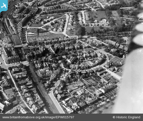
EPW015797 ENGLAND (1926). The railway station and residential area to the east, Harrogate, 1926
© Copyright OpenStreetMap contributors and licensed by the OpenStreetMap Foundation. 2026. Cartography is licensed as CC BY-SA.
Nearby Images (3)
EPW015797

EPW006596

EPW015798

Details
| Title | [EPW015797] The railway station and residential area to the east, Harrogate, 1926 |
| Reference | EPW015797 |
| Date | 5-June-1926 |
| Link | |
| Place name | HARROGATE |
| Parish | |
| District | |
| Country | ENGLAND |
| Easting / Northing | 430635, 455100 |
| Longitude / Latitude | -1.5326994345213, 53.990842678821 |
| National Grid Reference | SE306551 |
Pins

Ember Artist |
Friday 23rd of August 2019 05:27:49 PM | |
|
Ember Artist |
Friday 23rd of August 2019 05:25:56 PM | |
|
Ember Artist |
Friday 23rd of August 2019 05:24:36 PM | |
|
aoxomoxoa |
Saturday 4th of October 2014 01:22:37 PM | |
|
aoxomoxoa |
Saturday 4th of October 2014 07:32:03 AM | |
|
Survey of London historian |
Wednesday 1st of August 2012 06:53:36 PM | |
|
Survey of London historian |
Wednesday 1st of August 2012 06:51:13 PM | |

Class31 |
Monday 16th of July 2012 04:59:20 PM | |
|
Class31 |
Monday 16th of July 2012 04:58:47 PM | |
|
Class31 |
Monday 16th of July 2012 04:58:02 PM | |
|
Class31 |
Monday 16th of July 2012 04:56:09 PM | |
|
Class31 |
Monday 16th of July 2012 04:55:41 PM |