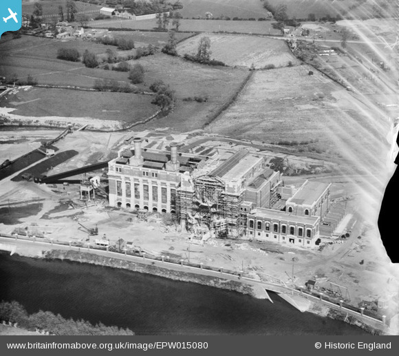
EPW015080 ENGLAND (1926). Stourport Power Station under construction, Stourport-on-Severn, 1926
© Copyright OpenStreetMap contributors and licensed by the OpenStreetMap Foundation. 2026. Cartography is licensed as CC BY-SA.
Nearby Images (20)
Details
| Title | [EPW015080] Stourport Power Station under construction, Stourport-on-Severn, 1926 |
| Reference | EPW015080 |
| Date | 12-April-1926 |
| Link | |
| Place name | STOURPORT-ON-SEVERN |
| Parish | STOURPORT-ON-SEVERN |
| District | |
| Country | ENGLAND |
| Easting / Northing | 381425, 270700 |
| Longitude / Latitude | -2.2726312597192, 52.333685589834 |
| National Grid Reference | SO814707 |
Pins
Be the first to add a comment to this image!


![[EPW015080] Stourport Power Station under construction, Stourport-on-Severn, 1926](http://britainfromabove.org.uk/sites/all/libraries/aerofilms-images/public/100x100/EPW/015/EPW015080.jpg)
![[EAW013592] Stourport Power Station, Stourport-on-Severn, 1948](http://britainfromabove.org.uk/sites/all/libraries/aerofilms-images/public/100x100/EAW/013/EAW013592.jpg)
![[EAW013586] Stourport Power Station, Stourport-on-Severn, 1948](http://britainfromabove.org.uk/sites/all/libraries/aerofilms-images/public/100x100/EAW/013/EAW013586.jpg)
![[EPW041764] The Power Station, Stourport-on-Severn, 1933](http://britainfromabove.org.uk/sites/all/libraries/aerofilms-images/public/100x100/EPW/041/EPW041764.jpg)
![[EAW013587] Stourport Power Station, Stourport-on-Severn, 1948](http://britainfromabove.org.uk/sites/all/libraries/aerofilms-images/public/100x100/EAW/013/EAW013587.jpg)
![[EPW015081] Stourport Power Station under construction, Stourport-on-Severn, 1926](http://britainfromabove.org.uk/sites/all/libraries/aerofilms-images/public/100x100/EPW/015/EPW015081.jpg)
![[EPW041763] The Power Station, Stourport-on-Severn, 1933](http://britainfromabove.org.uk/sites/all/libraries/aerofilms-images/public/100x100/EPW/041/EPW041763.jpg)
![[EAW013591] Stourport Power Station, Stourport-on-Severn, 1948](http://britainfromabove.org.uk/sites/all/libraries/aerofilms-images/public/100x100/EAW/013/EAW013591.jpg)
![[EAW013583] Stourport Power Station and environs, Stourport-on-Severn, 1948](http://britainfromabove.org.uk/sites/all/libraries/aerofilms-images/public/100x100/EAW/013/EAW013583.jpg)
![[EAW013582] Stourport Power Station and environs, Stourport-on-Severn, 1948](http://britainfromabove.org.uk/sites/all/libraries/aerofilms-images/public/100x100/EAW/013/EAW013582.jpg)
![[EAW013588] Stourport Power Station and environs, Stourport-on-Severn, 1948](http://britainfromabove.org.uk/sites/all/libraries/aerofilms-images/public/100x100/EAW/013/EAW013588.jpg)
![[EAW013584] Stourport Power Station and environs, Stourport-on-Severn, 1948](http://britainfromabove.org.uk/sites/all/libraries/aerofilms-images/public/100x100/EAW/013/EAW013584.jpg)
![[EAW013585] Stourport Power Station and environs, Stourport-on-Severn, 1948](http://britainfromabove.org.uk/sites/all/libraries/aerofilms-images/public/100x100/EAW/013/EAW013585.jpg)
![[EAW013593] Stourport Power Station, Stourport-on-Severn, 1948](http://britainfromabove.org.uk/sites/all/libraries/aerofilms-images/public/100x100/EAW/013/EAW013593.jpg)
![[EAW013589] Stourport Power Station and environs, Stourport-on-Severn, 1948](http://britainfromabove.org.uk/sites/all/libraries/aerofilms-images/public/100x100/EAW/013/EAW013589.jpg)
![[EAW013590] Stourport Power Station, Stourport-on-Severn, 1948](http://britainfromabove.org.uk/sites/all/libraries/aerofilms-images/public/100x100/EAW/013/EAW013590.jpg)
![[EAW013581] Stourport Power Station and environs, Stourport-on-Severn, 1948](http://britainfromabove.org.uk/sites/all/libraries/aerofilms-images/public/100x100/EAW/013/EAW013581.jpg)
![[EPW061728] The Gas Works, Stourport-on-Severn, 1939](http://britainfromabove.org.uk/sites/all/libraries/aerofilms-images/public/100x100/EPW/061/EPW061728.jpg)
![[EAW013579] Stourport Power Station and environs, Stourport-on-Severn, 1948](http://britainfromabove.org.uk/sites/all/libraries/aerofilms-images/public/100x100/EAW/013/EAW013579.jpg)
![[EPW061730] Cheapside and the Gas Works, Stourport-on-Severn, 1939](http://britainfromabove.org.uk/sites/all/libraries/aerofilms-images/public/100x100/EPW/061/EPW061730.jpg)