
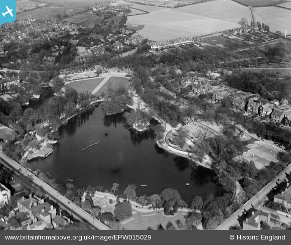
EPW015029 ENGLAND (1926). Hatherton Lake and environs, Walsall, 1926
© Copyright OpenStreetMap contributors and licensed by the OpenStreetMap Foundation. 2026. Cartography is licensed as CC BY-SA.
Nearby Images (5)
EPW015029

EPW015023

EPW005670

EPW005778

EPW024712

Details
| Title | [EPW015029] Hatherton Lake and environs, Walsall, 1926 |
| Reference | EPW015029 |
| Date | 12-April-1926 |
| Link | |
| Place name | WALSALL |
| Parish | |
| District | |
| Country | ENGLAND |
| Easting / Northing | 402017, 299103 |
| Longitude / Latitude | -1.9702238696097, 52.589368765453 |
| National Grid Reference | SP020991 |
Pins

Class31 |
Wednesday 31st of October 2012 05:40:59 PM | |
|
Class31 |
Wednesday 31st of October 2012 05:40:25 PM | |
|
Class31 |
Wednesday 31st of October 2012 05:40:02 PM | |
|
Class31 |
Wednesday 31st of October 2012 05:39:42 PM | |
|
Class31 |
Wednesday 31st of October 2012 05:39:18 PM | |
|
Class31 |
Wednesday 31st of October 2012 05:39:00 PM |
User Comment Contributions
Yes, I agree they mean the same thing and I think Hatherton Lake is the correct name. Lichfield Street runs across the bottom left corner and Broadway across the bottom right. Clearly visible are the tennis court on the extreme right and the large houses of Arboretum Road running behind them. The large pale field at the top of the site is the area occupied by Cameron Road and Argyle Road now. Mellish Road runs across the top left corner. |

K S Clark |
Friday 29th of June 2012 10:31:22 PM |
Are we assuming that the Hatherton Lake and the Arboretum are one and the same. Would welcome anyone els's views or comments please. |
rourerider |
Friday 29th of June 2012 02:44:21 PM |