
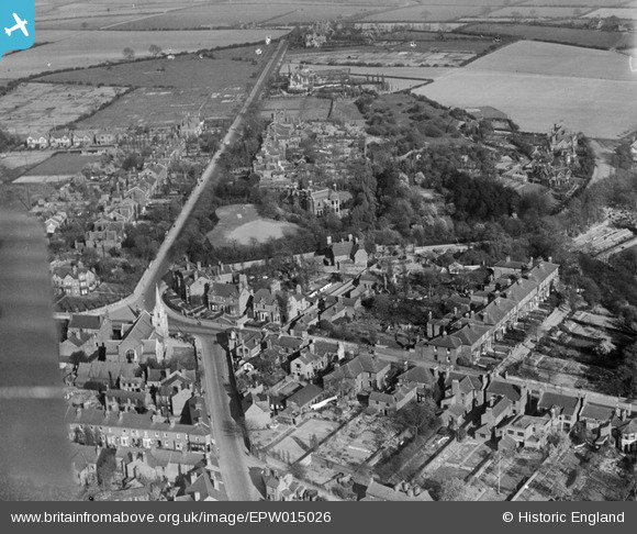
EPW015026 ENGLAND (1926). Moss Close and Mellish Road, Walsall, 1926
© Copyright OpenStreetMap contributors and licensed by the OpenStreetMap Foundation. 2026. Cartography is licensed as CC BY-SA.
Nearby Images (3)
EPW015026

EPW005670

EPW015023

Details
| Title | [EPW015026] Moss Close and Mellish Road, Walsall, 1926 |
| Reference | EPW015026 |
| Date | 12-April-1926 |
| Link | |
| Place name | WALSALL |
| Parish | |
| District | |
| Country | ENGLAND |
| Easting / Northing | 402087, 299368 |
| Longitude / Latitude | -1.9691888179044, 52.591751073225 |
| National Grid Reference | SP021994 |
Pins

Sandwell Street Kid |
Thursday 17th of April 2014 08:13:11 PM | |
|
Sandwell Street Kid |
Thursday 17th of April 2014 08:10:22 PM | |
|
Don White |
Thursday 13th of March 2014 10:47:17 AM | |
|
Tony |
Wednesday 28th of August 2013 09:31:11 PM | |

Class31 |
Wednesday 31st of October 2012 05:46:49 PM | |
|
Class31 |
Wednesday 31st of October 2012 05:46:05 PM | |
|
Class31 |
Wednesday 31st of October 2012 05:45:29 PM | |
|
Class31 |
Wednesday 31st of October 2012 05:45:13 PM | |
|
Class31 |
Wednesday 31st of October 2012 05:44:42 PM | |
|
Class31 |
Wednesday 31st of October 2012 05:44:23 PM |
User Comment Contributions
Great view of this area of Walsall. Never realised there were houses on the corner opposite the now demolished Methodist Church. |
Sandwell Street Kid |
Thursday 17th of April 2014 08:03:16 PM |