
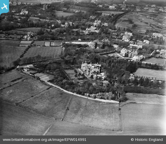
EPW014991 ENGLAND (1926). Mere Hall and environs, Noctorum, 1926
© Copyright OpenStreetMap contributors and licensed by the OpenStreetMap Foundation. 2026. Cartography is licensed as CC BY-SA.
Nearby Images (4)
EPW014991

EPW014990

EPW014989

EPW014988

Details
| Title | [EPW014991] Mere Hall and environs, Noctorum, 1926 |
| Reference | EPW014991 |
| Date | 11-April-1926 |
| Link | |
| Place name | NOCTORUM |
| Parish | |
| District | |
| Country | ENGLAND |
| Easting / Northing | 329448, 387533 |
| Longitude / Latitude | -3.0607300676711, 53.379666994146 |
| National Grid Reference | SJ294875 |
Pins

andycarole |
Sunday 3rd of March 2024 07:07:38 PM | |
|
andycarole |
Sunday 3rd of March 2024 07:06:28 PM | |
|
andycarole |
Sunday 3rd of March 2024 06:47:32 PM | |
|
andycarole |
Sunday 3rd of March 2024 01:57:28 PM | |
|
andycarole |
Sunday 3rd of March 2024 01:28:24 PM | |
|
andycarole |
Sunday 3rd of March 2024 01:15:55 PM | |
|
andycarole |
Sunday 3rd of March 2024 12:56:42 PM | |
|
andycarole |
Sunday 3rd of March 2024 12:31:22 PM | |
|
dhutch |
Friday 8th of October 2021 12:08:51 PM | |
|
dhutch |
Friday 8th of October 2021 12:08:08 PM | |
|
dhutch |
Friday 8th of October 2021 12:07:37 PM | |
|
dhutch |
Friday 8th of October 2021 12:06:19 PM | |
|
dhutch |
Friday 4th of September 2020 05:16:59 PM |
