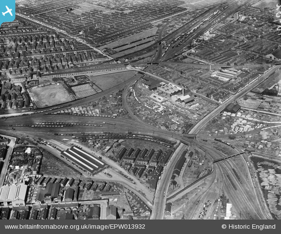
EPW013932 ENGLAND (1925). Timber Yards at Hedon Road and environs, Kingston upon Hull, 1925
© Copyright OpenStreetMap contributors and licensed by the OpenStreetMap Foundation. 2026. Cartography is licensed as CC BY-SA.
Nearby Images (28)
Details
| Title | [EPW013932] Timber Yards at Hedon Road and environs, Kingston upon Hull, 1925 |
| Reference | EPW013932 |
| Date | 25-July-1925 |
| Link | |
| Place name | KINGSTON UPON HULL |
| Parish | |
| District | |
| Country | ENGLAND |
| Easting / Northing | 511470, 429395 |
| Longitude / Latitude | -0.30937919590918, 53.748768433236 |
| National Grid Reference | TA115294 |
Pins

Mark |
Friday 27th of November 2020 01:05:08 PM | |

Mark |
Friday 27th of November 2020 01:04:41 PM | |

Mark |
Friday 27th of November 2020 01:04:13 PM | |

Mark |
Friday 27th of November 2020 01:02:34 PM | |

Mark |
Friday 27th of November 2020 01:00:21 PM | |

Mark |
Friday 27th of November 2020 12:59:26 PM | |

John Wass |
Wednesday 17th of February 2016 09:14:25 PM | |

John Wass |
Thursday 12th of February 2015 04:37:40 PM | |

John Wass |
Thursday 12th of February 2015 04:36:39 PM | |

John Wass |
Tuesday 11th of November 2014 03:27:14 PM | |

John Wass |
Monday 18th of August 2014 02:19:51 PM | |

CRB |
Saturday 19th of April 2014 04:52:21 PM | |

YingTang |
Friday 6th of July 2012 11:33:42 AM |


![[EPW013932] Timber Yards at Hedon Road and environs, Kingston upon Hull, 1925](http://britainfromabove.org.uk/sites/all/libraries/aerofilms-images/public/100x100/EPW/013/EPW013932.jpg)
![[EPW042801] Hollis Brothers Saw Mills, timber yards and environs, Kingston upon Hull, 1933](http://britainfromabove.org.uk/sites/all/libraries/aerofilms-images/public/100x100/EPW/042/EPW042801.jpg)
![[EPW013928] Timber Yards at Hedon Road and environs, Kingston upon Hull, 1925](http://britainfromabove.org.uk/sites/all/libraries/aerofilms-images/public/100x100/EPW/013/EPW013928.jpg)
![[EAW018592] The Hollis Brothers and Co Ltd Saw Mill and Timber Yard, Kingston Upon Hull, 1948](http://britainfromabove.org.uk/sites/all/libraries/aerofilms-images/public/100x100/EAW/018/EAW018592.jpg)
![[EPW042795] Hollis Brothers Saw Mills, timber yards and environs, Kingston upon Hull, 1933](http://britainfromabove.org.uk/sites/all/libraries/aerofilms-images/public/100x100/EPW/042/EPW042795.jpg)
![[EPW013929] Timber Yards at Hedon Road and environs, Kingston upon Hull, 1925](http://britainfromabove.org.uk/sites/all/libraries/aerofilms-images/public/100x100/EPW/013/EPW013929.jpg)
![[EAW018586] The Hollis Brothers and Co Ltd Saw Mill and Timber Yard, Kingston Upon Hull, 1948](http://britainfromabove.org.uk/sites/all/libraries/aerofilms-images/public/100x100/EAW/018/EAW018586.jpg)
![[EPW013933] Timber Yards at Hedon Road and environs, Kingston upon Hull, 1925](http://britainfromabove.org.uk/sites/all/libraries/aerofilms-images/public/100x100/EPW/013/EPW013933.jpg)
![[EPW013930] Timber Yards at Hedon Road and environs, Kingston upon Hull, 1925](http://britainfromabove.org.uk/sites/all/libraries/aerofilms-images/public/100x100/EPW/013/EPW013930.jpg)
![[EPW042798] Hollis Brothers Saw Mills, timber yards and environs, Kingston upon Hull, 1933](http://britainfromabove.org.uk/sites/all/libraries/aerofilms-images/public/100x100/EPW/042/EPW042798.jpg)
![[EPW042799] Hollis Brothers Saw Mills, timber yards and environs, Kingston upon Hull, 1933](http://britainfromabove.org.uk/sites/all/libraries/aerofilms-images/public/100x100/EPW/042/EPW042799.jpg)
![[EPW055038] The Hollis Bros & Co Ltd Saw Mill off Craven Street and environs, Kingston upon Hull, 1937. This image has been produced from a print.](http://britainfromabove.org.uk/sites/all/libraries/aerofilms-images/public/100x100/EPW/055/EPW055038.jpg)
![[EPW013931] Timber Yards at Hedon Road and environs, Kingston upon Hull, 1925](http://britainfromabove.org.uk/sites/all/libraries/aerofilms-images/public/100x100/EPW/013/EPW013931.jpg)
![[EPW042064] The Hollis Bros & Co Ltd sawmill and timber yard and environs, Kingston Upon Hull, 1933](http://britainfromabove.org.uk/sites/all/libraries/aerofilms-images/public/100x100/EPW/042/EPW042064.jpg)
![[EPW042797] Hollis Brothers Saw Mills, timber yards and environs, Kingston upon Hull, 1933](http://britainfromabove.org.uk/sites/all/libraries/aerofilms-images/public/100x100/EPW/042/EPW042797.jpg)
![[EPW042796] Hollis Brothers Saw Mills, timber yards and environs, Kingston upon Hull, 1933](http://britainfromabove.org.uk/sites/all/libraries/aerofilms-images/public/100x100/EPW/042/EPW042796.jpg)
![[EPW042065] The Hollis Bros & Co Ltd sawmill and timber yard and environs, Kingston Upon Hull, 1933](http://britainfromabove.org.uk/sites/all/libraries/aerofilms-images/public/100x100/EPW/042/EPW042065.jpg)
![[EPW042063] The Hollis Bros & Co Ltd sawmill and timber yard, Hedon Road and environs, Kingston Upon Hull, 1933](http://britainfromabove.org.uk/sites/all/libraries/aerofilms-images/public/100x100/EPW/042/EPW042063.jpg)
![[EAW018590] The Hollis Brothers and Co Ltd Saw Mill and Victoria Dock, Kingston Upon Hull, 1948. This image was marked by Aerofilms Ltd for photo editing.](http://britainfromabove.org.uk/sites/all/libraries/aerofilms-images/public/100x100/EAW/018/EAW018590.jpg)
![[EAW018585] The Hollis Brothers and Co Ltd Saw Mill and Timber Yard, Kingston Upon Hull, from the south, 1948. This image was marked by Aerofilms Ltd for photo editing.](http://britainfromabove.org.uk/sites/all/libraries/aerofilms-images/public/100x100/EAW/018/EAW018585.jpg)
![[EAW018589] The Hollis Brothers and Co Ltd Saw Mill and Timber Yard, Kingston Upon Hull, 1948](http://britainfromabove.org.uk/sites/all/libraries/aerofilms-images/public/100x100/EAW/018/EAW018589.jpg)
![[EPW042062] The Hollis Bros & Co Ltd sawmill and timber yard and environs, Kingston Upon Hull, from the south, 1933](http://britainfromabove.org.uk/sites/all/libraries/aerofilms-images/public/100x100/EPW/042/EPW042062.jpg)
![[EPW042061] The Hollis Bros & Co Ltd sawmill and timber yard and environs, Kingston Upon Hull, from the south-west, 1933](http://britainfromabove.org.uk/sites/all/libraries/aerofilms-images/public/100x100/EPW/042/EPW042061.jpg)
![[EPW055035] The Hollis Bros & Co Ltd Saw Mill off Craven Street and environs, Kingston upon Hull, from the south-west, 1937. This image has been produced from a copy-negative.](http://britainfromabove.org.uk/sites/all/libraries/aerofilms-images/public/100x100/EPW/055/EPW055035.jpg)
![[EAW018588] The Hollis Brothers and Co Ltd Saw Mill and Timber Yard, Kingston Upon Hull, 1948](http://britainfromabove.org.uk/sites/all/libraries/aerofilms-images/public/100x100/EAW/018/EAW018588.jpg)
![[EAW018587] The Hollis Brothers and Co Ltd Saw Mill, Kingston Upon Hull, 1948](http://britainfromabove.org.uk/sites/all/libraries/aerofilms-images/public/100x100/EAW/018/EAW018587.jpg)
![[EPW055044] Saw Mills and Timber Yards surrounding Hedon Road and Bellamy Street, Kingston upon Hull, 1937. This image has been produced from a copy-negative.](http://britainfromabove.org.uk/sites/all/libraries/aerofilms-images/public/100x100/EPW/055/EPW055044.jpg)
![[EAW018591] The Hollis Brothers and Co Ltd Saw Mill and Timber Yard and Victoria Dock, Kingston Upon Hull, 1948](http://britainfromabove.org.uk/sites/all/libraries/aerofilms-images/public/100x100/EAW/018/EAW018591.jpg)