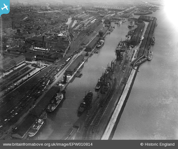
EPW010814 ENGLAND (1924). Albert Dock, Kingston upon Hull, 1924
© Copyright OpenStreetMap contributors and licensed by the OpenStreetMap Foundation. 2026. Cartography is licensed as CC BY-SA.
Nearby Images (9)
Details
| Title | [EPW010814] Albert Dock, Kingston upon Hull, 1924 |
| Reference | EPW010814 |
| Date | June-1924 |
| Link | |
| Place name | KINGSTON UPON HULL |
| Parish | |
| District | |
| Country | ENGLAND |
| Easting / Northing | 508778, 427596 |
| Longitude / Latitude | -0.35082198538295, 53.733172537446 |
| National Grid Reference | TA088276 |
Pins

Philip |
Friday 24th of October 2014 05:47:33 AM |


![[EPW010814] Albert Dock, Kingston upon Hull, 1924](http://britainfromabove.org.uk/sites/all/libraries/aerofilms-images/public/100x100/EPW/010/EPW010814.jpg)
![[EPW009400] The Albert Docks and environs, Kingston upon Hull, 1923](http://britainfromabove.org.uk/sites/all/libraries/aerofilms-images/public/100x100/EPW/009/EPW009400.jpg)
![[EAW004515] The docks, Kingston upon Hull, from the west, 1947](http://britainfromabove.org.uk/sites/all/libraries/aerofilms-images/public/100x100/EAW/004/EAW004515.jpg)
![[EPW009399] The Albert Docks and Neptune Street Goods Station, Kingston upon Hull, 1923](http://britainfromabove.org.uk/sites/all/libraries/aerofilms-images/public/100x100/EPW/009/EPW009399.jpg)
![[EPW009398] The Albert Docks and environs, Kingston upon Hull, 1923](http://britainfromabove.org.uk/sites/all/libraries/aerofilms-images/public/100x100/EPW/009/EPW009398.jpg)
![[EAW046147] Albert Dock, Neptune Street Station and environs, Kingston upon Hull, from the south-east, 1952](http://britainfromabove.org.uk/sites/all/libraries/aerofilms-images/public/100x100/EAW/046/EAW046147.jpg)
![[EPW036376] The Albert Dock, the Riverside Quay Clock Tower and the River Humber, Kingston upon Hull, from the south-west, 1931](http://britainfromabove.org.uk/sites/all/libraries/aerofilms-images/public/100x100/EPW/036/EPW036376.jpg)
![[EAW043294] Neptune Street Goods Station and the Smith and Nephew Associated Companies Ltd Factory on Neptune Street, Kingston upon Hull, 1952. This image was marked by Aerofilms Ltd for photo editing.](http://britainfromabove.org.uk/sites/all/libraries/aerofilms-images/public/100x100/EAW/043/EAW043294.jpg)
![[EAW004513] The docks, Kingston upon Hull, from the west, 1947](http://britainfromabove.org.uk/sites/all/libraries/aerofilms-images/public/100x100/EAW/004/EAW004513.jpg)