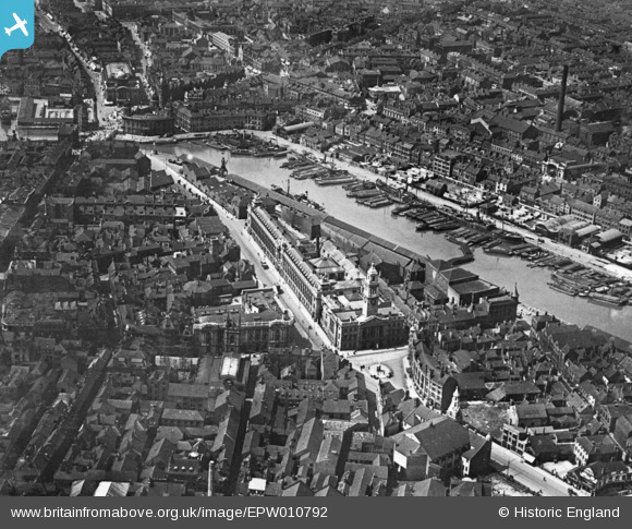
EPW010792 ENGLAND (1924). The Guildhall alongside Queen's Dock, Kingston upon Hull, 1924. This image has been produced from a copy-negative.
    © Copyright OpenStreetMap contributors and licensed by the OpenStreetMap Foundation. 2025. Cartography is licensed as CC BY-SA.
  
Nearby Images (8)
Details
| Title | [EPW010792] The Guildhall alongside Queen's Dock, Kingston upon Hull, 1924. This image has been produced from a copy-negative. | 
| Reference | EPW010792 | 
| Date | June-1924 | 
| Link | |
| Place name | KINGSTON UPON HULL | 
| Parish | |
| District | |
| Country | ENGLAND | 
| Easting / Northing | 509948, 428851 | 
| Longitude / Latitude | -0.33264550926296, 53.744203726406 | 
| National Grid Reference | TA099289 | 
Pins
|  Hammond department store |   Mark | Tuesday 3rd of March 2020 09:46:41 PM | 
|  Whitefriargate |   Mark | Tuesday 3rd of March 2020 09:44:37 PM | 
|  Parliament Street |   Mark | Tuesday 3rd of March 2020 09:43:59 PM | 
|  Prudential Tower |   Mark | Tuesday 3rd of March 2020 09:43:02 PM | 
|  Royal Institute, Albion Street |   Mark | Tuesday 3rd of March 2020 09:41:34 PM | 
|  Alfred Gelder Street |   Val | Monday 14th of November 2016 09:30:58 AM | 
|  Main Post Office |   Val | Monday 14th of November 2016 09:30:21 AM | 
|  St Mary's, Lowgate |   Val | Monday 14th of November 2016 09:29:57 AM | 
|  Wilberforce Monument in it's original position on Monument Bridge.  The column now stands at the eastern end of Queen's Gardens. |   Val | Monday 14th of November 2016 09:29:05 AM | 
|  Hull City Hall |   Val | Monday 14th of November 2016 09:27:55 AM | 
|  The Dock Offices, now Hull's maritime museum. |   Val | Monday 14th of November 2016 09:27:35 AM | 
|  Queen's Dock - the Line of the Town Docks in Hull mark the line of the old town wall which was demolished as they were built.  Queen's Dock was filled in and is now a city centre park called Queen's Gardens. |   Val | Monday 14th of November 2016 09:27:06 AM | 
|  On the top of the Guildhall clock tower there still is a "drop ball" time indicator for the ships in the adjacent "Queen's Dock.
Although as the dock is now filled in, there is no work for it these days. |   John Wass | Wednesday 22nd of April 2015 03:10:21 PM | 
 
             
  ![[EPW010792] The Guildhall alongside Queen's Dock, Kingston upon Hull, 1924. This image has been produced from a copy-negative.](http://britainfromabove.org.uk/sites/all/libraries/aerofilms-images/public/100x100/EPW/010/EPW010792.jpg) 
  
                                          ![[EPW036503] The Queen's Dock, Guildhall and environs, Kingston upon Hull, 1931](http://britainfromabove.org.uk/sites/all/libraries/aerofilms-images/public/100x100/EPW/036/EPW036503.jpg) 
 ![[EAW046135] Queen's Gardens and environs, Kingston upon Hull, 1952](http://britainfromabove.org.uk/sites/all/libraries/aerofilms-images/public/100x100/EAW/046/EAW046135.jpg) 
 ![[EPW012813] The Guildhall, Kingston upon Hull, 1925](http://britainfromabove.org.uk/sites/all/libraries/aerofilms-images/public/100x100/EPW/012/EPW012813.jpg) 
 ![[EAW015657] Humber Dock, the Old Harbour and city around Queen's Gardens, Kingston upon Hull, 1948. This image has been produced from a print.](http://britainfromabove.org.uk/sites/all/libraries/aerofilms-images/public/100x100/EAW/015/EAW015657.jpg) 
 ![[EPW036506] The Guildhall, Alfred Gelder Street and environs, Kingston upon Hulll, 1931](http://britainfromabove.org.uk/sites/all/libraries/aerofilms-images/public/100x100/EPW/036/EPW036506.jpg) 
 ![[EPW036504] The Market Place, Holy Trinity Church and environs, Kingston upon Hull, 1931](http://britainfromabove.org.uk/sites/all/libraries/aerofilms-images/public/100x100/EPW/036/EPW036504.jpg) 
 ![[EPW012811] The junction of Savile Street and George Street, Kingston upon Hull, 1925](http://britainfromabove.org.uk/sites/all/libraries/aerofilms-images/public/100x100/EPW/012/EPW012811.jpg)