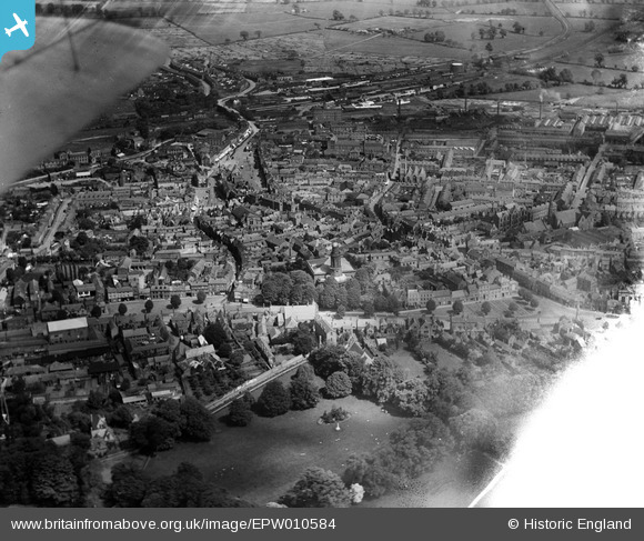
EPW010584 ENGLAND (1924). The Town Centre, Banbury, 1924
© Copyright OpenStreetMap contributors and licensed by the OpenStreetMap Foundation. 2026. Cartography is licensed as CC BY-SA.
Nearby Images (23)
Details
| Title | [EPW010584] The Town Centre, Banbury, 1924 |
| Reference | EPW010584 |
| Date | May-1924 |
| Link | |
| Place name | BANBURY |
| Parish | BANBURY |
| District | |
| Country | ENGLAND |
| Easting / Northing | 445464, 240561 |
| Longitude / Latitude | -1.3367762459497, 52.061141181956 |
| National Grid Reference | SP455406 |
Pins

RH |
Wednesday 18th of June 2025 05:12:29 AM | |

RH |
Wednesday 18th of June 2025 05:07:57 AM | |

RH |
Wednesday 18th of June 2025 05:06:25 AM | |

John W |
Sunday 21st of August 2016 05:02:06 PM | |

John W |
Sunday 21st of August 2016 05:01:26 PM | |

John W |
Sunday 21st of August 2016 05:00:44 PM | |

John W |
Sunday 21st of August 2016 04:57:18 PM | |

John W |
Sunday 21st of August 2016 04:55:40 PM | |

John W |
Sunday 21st of August 2016 04:54:03 PM | |

Class31 |
Thursday 30th of April 2015 08:26:03 AM | |

Carl R |
Thursday 24th of July 2014 10:35:29 AM |


![[EPW010584] The Town Centre, Banbury, 1924](http://britainfromabove.org.uk/sites/all/libraries/aerofilms-images/public/100x100/EPW/010/EPW010584.jpg)
![[EPW028257] High Street, Banbury, 1929. This image has been produced from a copy-negative.](http://britainfromabove.org.uk/sites/all/libraries/aerofilms-images/public/100x100/EPW/028/EPW028257.jpg)
![[EPW028252] Horse Fair and the town centre, Banbury, 1929. This image has been produced from a copy-negative.](http://britainfromabove.org.uk/sites/all/libraries/aerofilms-images/public/100x100/EPW/028/EPW028252.jpg)
![[EAW029563] Horse Fair and the town centre, Banbury, 1950](http://britainfromabove.org.uk/sites/all/libraries/aerofilms-images/public/100x100/EAW/029/EAW029563.jpg)
![[EPW028256] Horse Fair, Banbury, 1929. This image has been produced from a copy-negative.](http://britainfromabove.org.uk/sites/all/libraries/aerofilms-images/public/100x100/EPW/028/EPW028256.jpg)
![[EAW006314] Banbury Cross, Horse Fair and the town, Banbury, 1947](http://britainfromabove.org.uk/sites/all/libraries/aerofilms-images/public/100x100/EAW/006/EAW006314.jpg)
![[EAW006313] Banbury Cross, Horse Fair and the town, Banbury, 1947](http://britainfromabove.org.uk/sites/all/libraries/aerofilms-images/public/100x100/EAW/006/EAW006313.jpg)
![[EAW006322] Banbury Cross and Horse Fair, Banbury, 1947](http://britainfromabove.org.uk/sites/all/libraries/aerofilms-images/public/100x100/EAW/006/EAW006322.jpg)
![[EAW006315] Cheney & Sons Ltd on Calthorpe Street and environs, Banbury, 1947](http://britainfromabove.org.uk/sites/all/libraries/aerofilms-images/public/100x100/EAW/006/EAW006315.jpg)
![[EPW028258] The Market Place, Banbury, 1929. This image has been produced from a copy-negative.](http://britainfromabove.org.uk/sites/all/libraries/aerofilms-images/public/100x100/EPW/028/EPW028258.jpg)
![[EAW006311] Bridge Street, the Market Place and town centre, Banbury, 1947](http://britainfromabove.org.uk/sites/all/libraries/aerofilms-images/public/100x100/EAW/006/EAW006311.jpg)
![[EAW006317] Cheney & Sons Ltd on Calthorpe Street and environs, Banbury, 1947](http://britainfromabove.org.uk/sites/all/libraries/aerofilms-images/public/100x100/EAW/006/EAW006317.jpg)
![[EAW006320] Cheney & Sons Ltd on Calthorpe Street and environs, Banbury, 1947](http://britainfromabove.org.uk/sites/all/libraries/aerofilms-images/public/100x100/EAW/006/EAW006320.jpg)
![[EPW028255] Horse Fair and the town centre, Banbury, 1929. This image has been produced from a copy-negative.](http://britainfromabove.org.uk/sites/all/libraries/aerofilms-images/public/100x100/EPW/028/EPW028255.jpg)
![[EAW029564] Horse Fair and the town centre, Banbury, 1950](http://britainfromabove.org.uk/sites/all/libraries/aerofilms-images/public/100x100/EAW/029/EAW029564.jpg)
![[EAW006316] Cheney & Sons Ltd on Calthorpe Street and environs, Banbury, 1947](http://britainfromabove.org.uk/sites/all/libraries/aerofilms-images/public/100x100/EAW/006/EAW006316.jpg)
![[EAW006321] Cheney & Sons Ltd on Calthorpe Street and environs, Banbury, 1947](http://britainfromabove.org.uk/sites/all/libraries/aerofilms-images/public/100x100/EAW/006/EAW006321.jpg)
![[EPW006004] Banbury Cross and the town centre, Banbury, 1921. This image has been produced from a copy-negative.](http://britainfromabove.org.uk/sites/all/libraries/aerofilms-images/public/100x100/EPW/006/EPW006004.jpg)
![[EAW006319] Cheney & Sons Ltd, the Wesleyan Methodist Chapel on Marlborough Road and environs, Banbury, 1947](http://britainfromabove.org.uk/sites/all/libraries/aerofilms-images/public/100x100/EAW/006/EAW006319.jpg)
![[EAW029565] The town, Banbury, from the west, 1950](http://britainfromabove.org.uk/sites/all/libraries/aerofilms-images/public/100x100/EAW/029/EAW029565.jpg)
![[EAW006318] Cheney & Sons Ltd on Calthorpe Street and environs, Banbury, 1947](http://britainfromabove.org.uk/sites/all/libraries/aerofilms-images/public/100x100/EAW/006/EAW006318.jpg)
![[EPW028259] High Street and the Market Place, Banbury, 1929. This image has been produced from a copy-negative.](http://britainfromabove.org.uk/sites/all/libraries/aerofilms-images/public/100x100/EPW/028/EPW028259.jpg)
![[EAW006312] A view of the town centred upon Banbury Cross, Banbury, 1947](http://britainfromabove.org.uk/sites/all/libraries/aerofilms-images/public/100x100/EAW/006/EAW006312.jpg)

