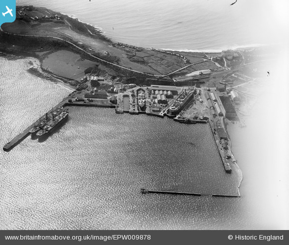
EPW009878 ENGLAND (1924). The Outer Harbour and docks, Falmouth, 1924
© Copyright OpenStreetMap contributors and licensed by the OpenStreetMap Foundation. 2026. Cartography is licensed as CC BY-SA.
Nearby Images (37)
Details
| Title | [EPW009878] The Outer Harbour and docks, Falmouth, 1924 |
| Reference | EPW009878 |
| Date | March-1924 |
| Link | |
| Place name | FALMOUTH |
| Parish | FALMOUTH |
| District | |
| Country | ENGLAND |
| Easting / Northing | 181973, 32618 |
| Longitude / Latitude | -5.052455299721, 50.15283550629 |
| National Grid Reference | SW820326 |
Pins
Be the first to add a comment to this image!


![[EPW009878] The Outer Harbour and docks, Falmouth, 1924](http://britainfromabove.org.uk/sites/all/libraries/aerofilms-images/public/100x100/EPW/009/EPW009878.jpg)
![[EPW055835] Falmouth Docks and Pendennis Castle, Falmouth, 1937](http://britainfromabove.org.uk/sites/all/libraries/aerofilms-images/public/100x100/EPW/055/EPW055835.jpg)
![[EPW021720] Cox and Co. Shipbuilders at Falmouth Docks, Falmouth, 1928](http://britainfromabove.org.uk/sites/all/libraries/aerofilms-images/public/100x100/EPW/021/EPW021720.jpg)
![[EPW009877] The Outer Harbour and Inner Harbour, docks and Iron Foundry, Falmouth, 1924](http://britainfromabove.org.uk/sites/all/libraries/aerofilms-images/public/100x100/EPW/009/EPW009877.jpg)
![[EPW055832] Falmouth Docks, Pendennis Castle and Trefusis Point, Falmouth, 1937](http://britainfromabove.org.uk/sites/all/libraries/aerofilms-images/public/100x100/EPW/055/EPW055832.jpg)
![[EPW021718] Cox and Co. shipbuilders at Falmouth Docks, Falmouth, 1928](http://britainfromabove.org.uk/sites/all/libraries/aerofilms-images/public/100x100/EPW/021/EPW021718.jpg)
![[EPW045674] Falmouth Docks, the Outer Harbour and Trefusis Point, Falmouth, from the south-east, 1934](http://britainfromabove.org.uk/sites/all/libraries/aerofilms-images/public/100x100/EPW/045/EPW045674.jpg)
![[EPW023355] Falmouth Docks, Falmouth, 1928](http://britainfromabove.org.uk/sites/all/libraries/aerofilms-images/public/100x100/EPW/023/EPW023355.jpg)
![[EPW021713] Cox and Co. Shipbuilders at Falmouth Docks, Falmouth, 1928](http://britainfromabove.org.uk/sites/all/libraries/aerofilms-images/public/100x100/EPW/021/EPW021713.jpg)
![[EPW009875] The Outer Harbour, docks and Iron Foundry, Falmouth, 1924](http://britainfromabove.org.uk/sites/all/libraries/aerofilms-images/public/100x100/EPW/009/EPW009875.jpg)
![[EPW021712] Cox and Co. Shipbuilders at Falmouth Docks, Falmouth, 1928](http://britainfromabove.org.uk/sites/all/libraries/aerofilms-images/public/100x100/EPW/021/EPW021712.jpg)
![[EPW009874] The Outer Harbour and docks, Falmouth, 1924](http://britainfromabove.org.uk/sites/all/libraries/aerofilms-images/public/100x100/EPW/009/EPW009874.jpg)
![[EPW021715] Cox and Co. Shipbuilders at Falmouth Docks, Falmouth, 1928](http://britainfromabove.org.uk/sites/all/libraries/aerofilms-images/public/100x100/EPW/021/EPW021715.jpg)
![[EPW023356] Falmouth Docks, Falmouth, 1928](http://britainfromabove.org.uk/sites/all/libraries/aerofilms-images/public/100x100/EPW/023/EPW023356.jpg)
![[EPW023171] Number 3 and Number 4 Docks, Falmouth, 1928](http://britainfromabove.org.uk/sites/all/libraries/aerofilms-images/public/100x100/EPW/023/EPW023171.jpg)
![[EPW009879] The Outer Harbour, docks and Iron Foundry, Falmouth, 1924](http://britainfromabove.org.uk/sites/all/libraries/aerofilms-images/public/100x100/EPW/009/EPW009879.jpg)
![[EPW021714] Cox and Co. Shipbuilders at Falmouth Docks, Falmouth, 1928](http://britainfromabove.org.uk/sites/all/libraries/aerofilms-images/public/100x100/EPW/021/EPW021714.jpg)
![[EPW023371] Falmouth Docks, Falmouth, 1928](http://britainfromabove.org.uk/sites/all/libraries/aerofilms-images/public/100x100/EPW/023/EPW023371.jpg)
![[EPW009876] The Outer Harbour, docks and Iron Foundry, Falmouth, 1924](http://britainfromabove.org.uk/sites/all/libraries/aerofilms-images/public/100x100/EPW/009/EPW009876.jpg)
![[EPW045677] The town with boats moored in the Outer and Inner Harbours, Falmouth, 1934](http://britainfromabove.org.uk/sites/all/libraries/aerofilms-images/public/100x100/EPW/045/EPW045677.jpg)
![[EPW023359] Falmouth Docks, Falmouth, 1928](http://britainfromabove.org.uk/sites/all/libraries/aerofilms-images/public/100x100/EPW/023/EPW023359.jpg)
![[EPW055833] Falmouth Docks, Falmouth, 1937. This image has been produced from a copy-negative.](http://britainfromabove.org.uk/sites/all/libraries/aerofilms-images/public/100x100/EPW/055/EPW055833.jpg)
![[EPW023358] Falmouth Docks, Falmouth, 1928](http://britainfromabove.org.uk/sites/all/libraries/aerofilms-images/public/100x100/EPW/023/EPW023358.jpg)
![[EPW023349] Falmouth Docks, Falmouth, 1928](http://britainfromabove.org.uk/sites/all/libraries/aerofilms-images/public/100x100/EPW/023/EPW023349.jpg)
![[EPW023347] Falmouth Docks, Falmouth, 1928](http://britainfromabove.org.uk/sites/all/libraries/aerofilms-images/public/100x100/EPW/023/EPW023347.jpg)
![[EPW023350] Falmouth Docks, Falmouth, 1928](http://britainfromabove.org.uk/sites/all/libraries/aerofilms-images/public/100x100/EPW/023/EPW023350.jpg)
![[EPW045672] Falmouth Docks, the Outer Harbour and Trefusis Point, Falmouth, 1934](http://britainfromabove.org.uk/sites/all/libraries/aerofilms-images/public/100x100/EPW/045/EPW045672.jpg)
![[EPW023352] Falmouth Docks, Falmouth, 1928](http://britainfromabove.org.uk/sites/all/libraries/aerofilms-images/public/100x100/EPW/023/EPW023352.jpg)
![[EPW023351] Falmouth Docks and the town, Falmouth, from the east, 1928](http://britainfromabove.org.uk/sites/all/libraries/aerofilms-images/public/100x100/EPW/023/EPW023351.jpg)
![[EPW055834] Falmouth Docks and Pendennis Castle, Falmouth, 1937](http://britainfromabove.org.uk/sites/all/libraries/aerofilms-images/public/100x100/EPW/055/EPW055834.jpg)
![[EPW023357] Falmouth Docks, Falmouth, 1928](http://britainfromabove.org.uk/sites/all/libraries/aerofilms-images/public/100x100/EPW/023/EPW023357.jpg)
![[EPW045679] Falmouth Docks and the Outer Harbour, Falmouth, 1934](http://britainfromabove.org.uk/sites/all/libraries/aerofilms-images/public/100x100/EPW/045/EPW045679.jpg)
![[EPW021717] Cox and Co. shipbuilders at Falmouth Docks, Falmouth, 1928](http://britainfromabove.org.uk/sites/all/libraries/aerofilms-images/public/100x100/EPW/021/EPW021717.jpg)
![[EPW021716] Falmouth Docks and Pendennis Castle, Falmouth, from the north-west, 1928](http://britainfromabove.org.uk/sites/all/libraries/aerofilms-images/public/100x100/EPW/021/EPW021716.jpg)
![[EPW045675] Falmouth Docks, the Outer Harbour and Trefusis Point, Falmouth, 1934](http://britainfromabove.org.uk/sites/all/libraries/aerofilms-images/public/100x100/EPW/045/EPW045675.jpg)
![[EAW033625] The Docks, Falmouth, 1950](http://britainfromabove.org.uk/sites/all/libraries/aerofilms-images/public/100x100/EAW/033/EAW033625.jpg)
![[EAW033626] The Docks, Falmouth, 1950](http://britainfromabove.org.uk/sites/all/libraries/aerofilms-images/public/100x100/EAW/033/EAW033626.jpg)