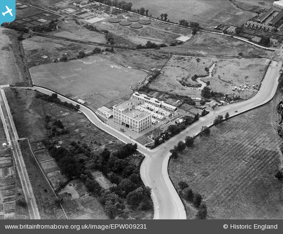
EPW009231 ENGLAND (1923). The Virol Factory and Sports Ground, Ealing, 1923
© Copyright OpenStreetMap contributors and licensed by the OpenStreetMap Foundation. 2026. Cartography is licensed as CC BY-SA.
Nearby Images (33)
Details
| Title | [EPW009231] The Virol Factory and Sports Ground, Ealing, 1923 |
| Reference | EPW009231 |
| Date | 1923 |
| Link | |
| Place name | EALING |
| Parish | |
| District | |
| Country | ENGLAND |
| Easting / Northing | 518300, 182862 |
| Longitude / Latitude | -0.294295192239, 51.531775831201 |
| National Grid Reference | TQ183829 |


![[EPW009231] The Virol Factory and Sports Ground, Ealing, 1923](http://britainfromabove.org.uk/sites/all/libraries/aerofilms-images/public/100x100/EPW/009/EPW009231.jpg)
![[EPW009229] The Virol Factory and Sports Ground, Ealing, 1923](http://britainfromabove.org.uk/sites/all/libraries/aerofilms-images/public/100x100/EPW/009/EPW009229.jpg)
![[EPW008079] The Virol Factory, Ealing, 1922. This image has been produced from a print.](http://britainfromabove.org.uk/sites/all/libraries/aerofilms-images/public/100x100/EPW/008/EPW008079.jpg)
![[EPW009228] The Virol Factory and Sports Ground, Ealing, 1923](http://britainfromabove.org.uk/sites/all/libraries/aerofilms-images/public/100x100/EPW/009/EPW009228.jpg)
![[EPW009226] The Virol Factory and Sports Ground, Ealing, 1923](http://britainfromabove.org.uk/sites/all/libraries/aerofilms-images/public/100x100/EPW/009/EPW009226.jpg)
![[EPW022714] The Virol Factory and Sports Ground, Ealing, 1928](http://britainfromabove.org.uk/sites/all/libraries/aerofilms-images/public/100x100/EPW/022/EPW022714.jpg)
![[EPW022712] The Virol Factory and Sports Ground, Ealing, 1928](http://britainfromabove.org.uk/sites/all/libraries/aerofilms-images/public/100x100/EPW/022/EPW022712.jpg)
![[EPW022713] The Virol Factory and Sports Ground, Ealing, 1928](http://britainfromabove.org.uk/sites/all/libraries/aerofilms-images/public/100x100/EPW/022/EPW022713.jpg)
![[EAW048757] The Kiwi Polish Co Works and the surrounding area, Ealing, 1953. This image was marked by Aerofilms Ltd for photo editing.](http://britainfromabove.org.uk/sites/all/libraries/aerofilms-images/public/100x100/EAW/048/EAW048757.jpg)
![[EPW009222] The Virol Factory and Sports Grounds, Ealing, 1923](http://britainfromabove.org.uk/sites/all/libraries/aerofilms-images/public/100x100/EPW/009/EPW009222.jpg)
![[EPW009225] The Virol Factory and Sports Ground, Ealing, 1923](http://britainfromabove.org.uk/sites/all/libraries/aerofilms-images/public/100x100/EPW/009/EPW009225.jpg)
![[EPW009230] The Virol Factory and Sports Ground, Ealing, 1923](http://britainfromabove.org.uk/sites/all/libraries/aerofilms-images/public/100x100/EPW/009/EPW009230.jpg)
![[EAW048741] The Kiwi Polish Co Factory, the Virol Food Products Factory and environs, Ealing, 1953. This image was marked by Aerofilms Ltd for photo editing.](http://britainfromabove.org.uk/sites/all/libraries/aerofilms-images/public/100x100/EAW/048/EAW048741.jpg)
![[EAW048742] The Kiwi Polish Co Factory, the Virol Food Products Factory and environs, Ealing, 1953. This image was marked by Aerofilms Ltd for photo editing.](http://britainfromabove.org.uk/sites/all/libraries/aerofilms-images/public/100x100/EAW/048/EAW048742.jpg)
![[EAW048738] The Kiwi Polish Co Factory and environs, Ealing, 1953. This image was marked by Aerofilms Ltd for photo editing.](http://britainfromabove.org.uk/sites/all/libraries/aerofilms-images/public/100x100/EAW/048/EAW048738.jpg)
![[EPW009227] The Virol Factory and Sports Ground, Ealing, 1923](http://britainfromabove.org.uk/sites/all/libraries/aerofilms-images/public/100x100/EPW/009/EPW009227.jpg)
![[EAW048746] The Kiwi Polish Co Factory and the surrounding area, Ealing, 1953. This image was marked by Aerofilms Ltd for photo editing.](http://britainfromabove.org.uk/sites/all/libraries/aerofilms-images/public/100x100/EAW/048/EAW048746.jpg)
![[EAW048751] The Wolf Electric Tool Works, Kiwi Polish Co Works and Virol Food Products Factory, Ealing, 1953. This image was marked by Aerofilms Ltd for photo editing.](http://britainfromabove.org.uk/sites/all/libraries/aerofilms-images/public/100x100/EAW/048/EAW048751.jpg)
![[EAW048745] The Kiwi Polish Co Factory and environs, Ealing, 1953. This image was marked by Aerofilms Ltd for photo editing.](http://britainfromabove.org.uk/sites/all/libraries/aerofilms-images/public/100x100/EAW/048/EAW048745.jpg)
![[EAW048739] The Kiwi Polish Co Factory and environs, Ealing, 1953. This image was marked by Aerofilms Ltd for photo editing.](http://britainfromabove.org.uk/sites/all/libraries/aerofilms-images/public/100x100/EAW/048/EAW048739.jpg)
![[EPW009224] The Virol Factory and Sports Ground, Ealing, 1923. This image has been produced from a copy negative.](http://britainfromabove.org.uk/sites/all/libraries/aerofilms-images/public/100x100/EPW/009/EPW009224.jpg)
![[EAW048743] The Kiwi Polish Co Factory and environs, Ealing, 1953. This image was marked by Aerofilms Ltd for photo editing.](http://britainfromabove.org.uk/sites/all/libraries/aerofilms-images/public/100x100/EAW/048/EAW048743.jpg)
![[EAW048752] The Wolf Electric Tool Works, Kiwi Polish Co Works and Virol Food Products Factory, Ealing, 1953. This image was marked by Aerofilms Ltd for photo editing.](http://britainfromabove.org.uk/sites/all/libraries/aerofilms-images/public/100x100/EAW/048/EAW048752.jpg)
![[EAW048753] The Wolf Electric Tool Works, Kiwi Polish Co Works and Virol Food Products Factory, Ealing, 1953. This image was marked by Aerofilms Ltd for photo editing.](http://britainfromabove.org.uk/sites/all/libraries/aerofilms-images/public/100x100/EAW/048/EAW048753.jpg)
![[EAW048747] The Wolf Electric Tool Works, Kiwi Polish Co Works and Virol Food Products Factory, Ealing, 1953. This image was marked by Aerofilms Ltd for photo editing.](http://britainfromabove.org.uk/sites/all/libraries/aerofilms-images/public/100x100/EAW/048/EAW048747.jpg)
![[EAW048755] The Wolf Electric Tool Works, Kiwi Polish Co Works and Virol Food Products Factory, Ealing, 1953. This image was marked by Aerofilms Ltd for photo editing.](http://britainfromabove.org.uk/sites/all/libraries/aerofilms-images/public/100x100/EAW/048/EAW048755.jpg)
![[EAW048748] The Wolf Electric Tool Works, Kiwi Polish Co Works and Virol Food Products Factory, Ealing, 1953. This image was marked by Aerofilms Ltd for photo editing.](http://britainfromabove.org.uk/sites/all/libraries/aerofilms-images/public/100x100/EAW/048/EAW048748.jpg)
![[EAW048749] The Wolf Electric Tool Works alongside the Kiwi Polish Co Works, Ealing, 1953. This image was marked by Aerofilms Ltd for photo editing.](http://britainfromabove.org.uk/sites/all/libraries/aerofilms-images/public/100x100/EAW/048/EAW048749.jpg)
![[EAW048740] The Kiwi Polish Co Factory and environs, Ealing, 1953. This image was marked by Aerofilms Ltd for photo editing.](http://britainfromabove.org.uk/sites/all/libraries/aerofilms-images/public/100x100/EAW/048/EAW048740.jpg)
![[EAW048750] The Wolf Electric Tool Works alongside the Kiwi Polish Co Works, Ealing, 1953. This image was marked by Aerofilms Ltd for photo editing.](http://britainfromabove.org.uk/sites/all/libraries/aerofilms-images/public/100x100/EAW/048/EAW048750.jpg)
![[EAW048744] The Kiwi Polish Co Factory and environs, Ealing, 1953. This image was marked by Aerofilms Ltd for photo editing.](http://britainfromabove.org.uk/sites/all/libraries/aerofilms-images/public/100x100/EAW/048/EAW048744.jpg)
![[EAW048754] The Wolf Electric Tool Works alongside the Kiwi Polish Co Works and environs, Ealing, 1953. This image was marked by Aerofilms Ltd for photo editing.](http://britainfromabove.org.uk/sites/all/libraries/aerofilms-images/public/100x100/EAW/048/EAW048754.jpg)
![[EPW040772] The Virol Factory, Hanger Lane and Wellington House, Ealing, 1932. This image has been produced from a damaged negative.](http://britainfromabove.org.uk/sites/all/libraries/aerofilms-images/public/100x100/EPW/040/EPW040772.jpg)
