
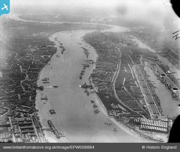
EPW008884 ENGLAND (1923). The River Thames, North Woolwich, from the east, 1923
© Copyright OpenStreetMap contributors and licensed by the OpenStreetMap Foundation. 2026. Cartography is licensed as CC BY-SA.
Nearby Images (2)
EPW008884

EAW046499

Details
| Title | [EPW008884] The River Thames, North Woolwich, from the east, 1923 |
| Reference | EPW008884 |
| Date | July-1923 |
| Link | |
| Place name | NORTH WOOLWICH |
| Parish | |
| District | |
| Country | ENGLAND |
| Easting / Northing | 543545, 179732 |
| Longitude / Latitude | 0.068191411481413, 51.497793344639 |
| National Grid Reference | TQ435797 |
Pins

Kentishman |
Tuesday 24th of December 2024 05:53:24 AM | |
|
Kentishman |
Tuesday 24th of December 2024 05:52:09 AM | |
|
John W |
Monday 2nd of May 2016 06:24:53 PM | |
|
John W |
Monday 2nd of May 2016 06:23:53 PM | |
|
John W |
Monday 2nd of May 2016 06:23:05 PM | |
|
John W |
Monday 2nd of May 2016 06:21:59 PM | |
|
pjl |
Sunday 4th of October 2015 07:42:58 PM | |
Originally the Eastern Counties Railway (later Great Eastern) ferry pier to take passengers from North Woolwich to the south side of the river, from soon after the passenger service to the station started in 1847. The ferry service stopped in 1908, but the pier was retained for pleasure traffic and passed to the LNER in 1923. I don't have any information as to when the tug company took over the pier. |
John W |
Monday 2nd of May 2016 06:19:51 PM |

Onthecoast |
Monday 20th of May 2013 11:21:07 AM | |
|
Onthecoast |
Monday 20th of May 2013 11:20:27 AM | |
|
Onthecoast |
Monday 20th of May 2013 11:19:33 AM |