
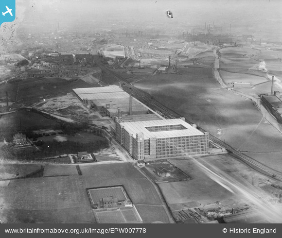
EPW007778 ENGLAND (1922). The Dunlop Mills, Rochdale, 1922
© Copyright OpenStreetMap contributors and licensed by the OpenStreetMap Foundation. 2025. Cartography is licensed as CC BY-SA.
Nearby Images (5)
EPW007778

EPW007779

EPW007780
EPW007777

EPW016706

Details
| Title | [EPW007778] The Dunlop Mills, Rochdale, 1922 |
| Reference | EPW007778 |
| Date | 13-May-1922 |
| Link | |
| Place name | ROCHDALE |
| Parish | |
| District | |
| Country | ENGLAND |
| Easting / Northing | 388703, 411397 |
| Longitude / Latitude | -2.1707222276398, 53.598782273446 |
| National Grid Reference | SD887114 |
Pins
 Mikeya |
Monday 17th of September 2018 10:25:18 PM | |
Mikeya |
Monday 17th of September 2018 10:18:25 PM | |
Mikeya |
Monday 17th of September 2018 10:17:47 PM | |
Mikeya |
Monday 17th of September 2018 10:17:05 PM | |
Mikeya |
Monday 17th of September 2018 10:16:19 PM |