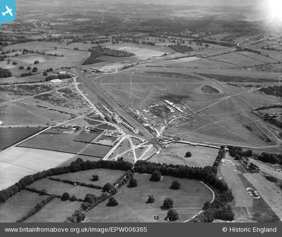
EPW006365 ENGLAND (1921). Epsom Racecourse, Epsom Downs, from the north-west, 1921
© Copyright OpenStreetMap contributors and licensed by the OpenStreetMap Foundation. 2026. Cartography is licensed as CC BY-SA.
Nearby Images (25)
Details
| Title | [EPW006365] Epsom Racecourse, Epsom Downs, from the north-west, 1921 |
| Reference | EPW006365 |
| Date | 31-May-1921 |
| Link | |
| Place name | EPSOM DOWNS |
| Parish | |
| District | |
| Country | ENGLAND |
| Easting / Northing | 521477, 158675 |
| Longitude / Latitude | -0.25680346716441, 51.313697680121 |
| National Grid Reference | TQ215587 |
Pins
Be the first to add a comment to this image!


![[EPW006365] Epsom Racecourse, Epsom Downs, from the north-west, 1921](http://britainfromabove.org.uk/sites/all/libraries/aerofilms-images/public/100x100/EPW/006/EPW006365.jpg)
![[EAW036443] Epsom Downs, Epsom Racecourse on Derby Day, 1951. This image has been produced from a print.](http://britainfromabove.org.uk/sites/all/libraries/aerofilms-images/public/100x100/EAW/036/EAW036443.jpg)
![[EPW006483] Epsom Racecourse on Derby Day, Epsom Downs, from the north-west, 1921](http://britainfromabove.org.uk/sites/all/libraries/aerofilms-images/public/100x100/EPW/006/EPW006483.jpg)
![[EPW035516] Derby Day, Epsom Downs, from the north-west, 1931](http://britainfromabove.org.uk/sites/all/libraries/aerofilms-images/public/100x100/EPW/035/EPW035516.jpg)
![[EAW017625] The Paddock at Epsom Racecourse, Epsom Downs, 1948. This image has been produced from a print.](http://britainfromabove.org.uk/sites/all/libraries/aerofilms-images/public/100x100/EAW/017/EAW017625.jpg)
![[EAW036444] Epsom Downs, Epsom Racecourse on Derby Day, 1951. This image has been produced from a print.](http://britainfromabove.org.uk/sites/all/libraries/aerofilms-images/public/100x100/EAW/036/EAW036444.jpg)
![[EPW006484] Epsom Racecourse on Derby Day, Epsom Downs, from the north-west, 1921](http://britainfromabove.org.uk/sites/all/libraries/aerofilms-images/public/100x100/EPW/006/EPW006484.jpg)
![[EPW007901] Epsom Racecourse, Epsom Downs, from the west, 1922](http://britainfromabove.org.uk/sites/all/libraries/aerofilms-images/public/100x100/EPW/007/EPW007901.jpg)
![[EPW035519] Derby Day, Epsom Downs, from the north-west, 1931](http://britainfromabove.org.uk/sites/all/libraries/aerofilms-images/public/100x100/EPW/035/EPW035519.jpg)
![[EPW035521] Derby Day, Epsom Downs, from the north-west, 1931](http://britainfromabove.org.uk/sites/all/libraries/aerofilms-images/public/100x100/EPW/035/EPW035521.jpg)
![[EPW035524] Derby Day, Epsom Downs, from the north-west, 1931](http://britainfromabove.org.uk/sites/all/libraries/aerofilms-images/public/100x100/EPW/035/EPW035524.jpg)
![[EPW017557] The Epsom racecourse grandstand under construction, Epsom Downs, 1927. This image was marked by Aerofilms Ltd for photo editing.](http://britainfromabove.org.uk/sites/all/libraries/aerofilms-images/public/100x100/EPW/017/EPW017557.jpg)
![[EPW008666] The Paddock and Home Straight, Epsom, from the west, 1923](http://britainfromabove.org.uk/sites/all/libraries/aerofilms-images/public/100x100/EPW/008/EPW008666.jpg)
![[EAW043436] Epsom Downs, Derby Day at Epsom Racecourse, from the north-west, 1952](http://britainfromabove.org.uk/sites/all/libraries/aerofilms-images/public/100x100/EAW/043/EAW043436.jpg)
![[EPW027456] Epsom Downs, Derby Day, 1929](http://britainfromabove.org.uk/sites/all/libraries/aerofilms-images/public/100x100/EPW/027/EPW027456.jpg)
![[EPW027458] Epsom Downs, Derby Day, 1929](http://britainfromabove.org.uk/sites/all/libraries/aerofilms-images/public/100x100/EPW/027/EPW027458.jpg)
![[EPW008703] The Grandstand and Home Straight, Epsom, 1923](http://britainfromabove.org.uk/sites/all/libraries/aerofilms-images/public/100x100/EPW/008/EPW008703.jpg)
![[EPW025157] Epsom Downs Race Course and Grand Stand, Epsom Downs, 1928](http://britainfromabove.org.uk/sites/all/libraries/aerofilms-images/public/100x100/EPW/025/EPW025157.jpg)
![[EPW008671] The Winning Post, Epsom, 1923](http://britainfromabove.org.uk/sites/all/libraries/aerofilms-images/public/100x100/EPW/008/EPW008671.jpg)
![[EPW017555] The Epsom racecourse grandstand under construction, Epsom Downs, 1927. This image was marked by Aerofilms Ltd for photo editing.](http://britainfromabove.org.uk/sites/all/libraries/aerofilms-images/public/100x100/EPW/017/EPW017555.jpg)
![[EPW035522] The Grandstand and racecouse on Derby Day, Epsom Downs, from the north-west, 1931. This image has been produced from a damaged negative.](http://britainfromabove.org.uk/sites/all/libraries/aerofilms-images/public/100x100/EPW/035/EPW035522.jpg)
![[EPW035511] The Grandstand and racecourse on Derby Day, Epsom Downs, from the north, 1931](http://britainfromabove.org.uk/sites/all/libraries/aerofilms-images/public/100x100/EPW/035/EPW035511.jpg)
![[EPW007652] The Grandstand at Epsom Racecourse, Epsom, 1922](http://britainfromabove.org.uk/sites/all/libraries/aerofilms-images/public/100x100/EPW/007/EPW007652.jpg)
![[EPW025156] Epsom Downs Race Course and Grand Stand, Epsom Downs, 1928](http://britainfromabove.org.uk/sites/all/libraries/aerofilms-images/public/100x100/EPW/025/EPW025156.jpg)
![[EAW017624] The Grandstand at Epsom Racecourse, Epsom Downs, from the south, 1948. This image has been produced from a print.](http://britainfromabove.org.uk/sites/all/libraries/aerofilms-images/public/100x100/EAW/017/EAW017624.jpg)