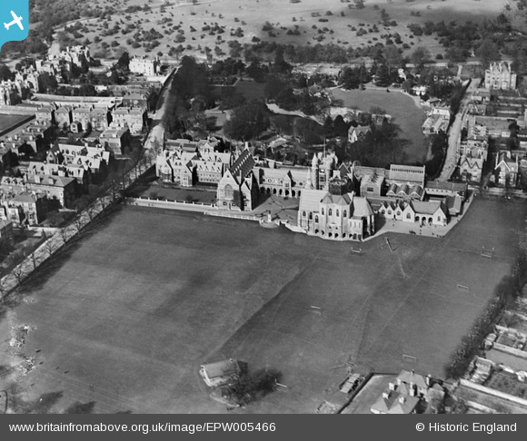
EPW005466 ENGLAND (1921). Clifton College, Clifton, 1921
© Copyright OpenStreetMap contributors and licensed by the OpenStreetMap Foundation. 2026. Cartography is licensed as CC BY-SA.
Nearby Images (13)
Details
| Title | [EPW005466] Clifton College, Clifton, 1921 |
| Reference | EPW005466 |
| Date | 20-March-1921 |
| Link | |
| Place name | CLIFTON |
| Parish | |
| District | |
| Country | ENGLAND |
| Easting / Northing | 357002, 173850 |
| Longitude / Latitude | -2.6189947685167, 51.461501236226 |
| National Grid Reference | ST570739 |
Pins
User Comment Contributions
Clifton College looking east 29/09/2013 |

Class31 |
Tuesday 1st of October 2013 09:08:23 AM |


![[EPW005466] Clifton College, Clifton, 1921](http://britainfromabove.org.uk/sites/all/libraries/aerofilms-images/public/100x100/EPW/005/EPW005466.jpg)
![[EPW005467] Clifton College, Clifton, 1921](http://britainfromabove.org.uk/sites/all/libraries/aerofilms-images/public/100x100/EPW/005/EPW005467.jpg)
![[EPW005468] Clifton College, Clifton, 1921](http://britainfromabove.org.uk/sites/all/libraries/aerofilms-images/public/100x100/EPW/005/EPW005468.jpg)
![[EPW010231] Clifton College and environs, Clifton, 1924. This image has been produced from a print.](http://britainfromabove.org.uk/sites/all/libraries/aerofilms-images/public/100x100/EPW/010/EPW010231.jpg)
![[EPW048288] Bristol Zoo Gardens, Clifton, 1935](http://britainfromabove.org.uk/sites/all/libraries/aerofilms-images/public/100x100/EPW/048/EPW048288.jpg)
![[EPW012004] Clifton College, Bristol, 1924. This image has been produced from a print.](http://britainfromabove.org.uk/sites/all/libraries/aerofilms-images/public/100x100/EPW/012/EPW012004.jpg)
![[EPW048289] Bristol Zoo Gardens, Clifton College and Emmanuel Church, Clifton, 1935](http://britainfromabove.org.uk/sites/all/libraries/aerofilms-images/public/100x100/EPW/048/EPW048289.jpg)
![[EPW048286] Bristol Zoo Gardens, Clifton College and Emmanuel Church, Clifton, 1935](http://britainfromabove.org.uk/sites/all/libraries/aerofilms-images/public/100x100/EPW/048/EPW048286.jpg)
![[EPW048300] Observatory Hill, College Close and the surrounding residential area, Clifton, 1935](http://britainfromabove.org.uk/sites/all/libraries/aerofilms-images/public/100x100/EPW/048/EPW048300.jpg)
![[EPW048287] Bristol Zoo Gardens, Clifton, 1935](http://britainfromabove.org.uk/sites/all/libraries/aerofilms-images/public/100x100/EPW/048/EPW048287.jpg)
![[EPW049533] Clifton College, Bristol Zoo and environs, Clifton, 1935](http://britainfromabove.org.uk/sites/all/libraries/aerofilms-images/public/100x100/EPW/049/EPW049533.jpg)
![[EPW048296] The suburb of Clifton alongside Clifton Down, Clifton, 1935](http://britainfromabove.org.uk/sites/all/libraries/aerofilms-images/public/100x100/EPW/048/EPW048296.jpg)
![[EPW048293] The Clifton Observatory, College Close and the surrounding residential area, Clifton, 1935](http://britainfromabove.org.uk/sites/all/libraries/aerofilms-images/public/100x100/EPW/048/EPW048293.jpg)