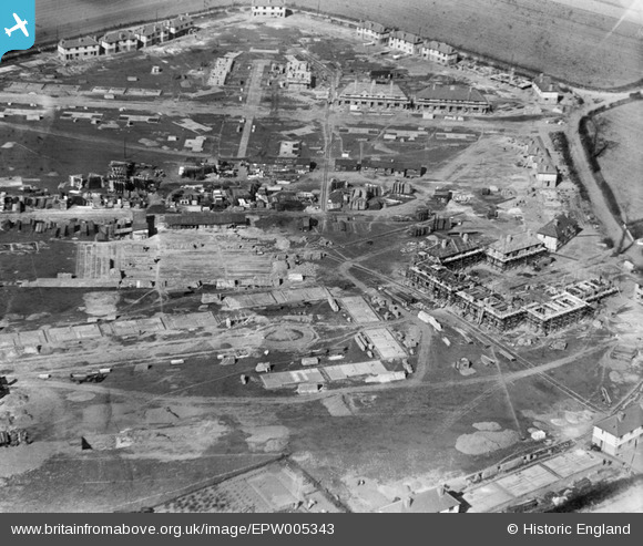
EPW005343 ENGLAND (1921). A new housing estate under construction at Marsh Green Road, Dagenham, 1921
© Copyright OpenStreetMap contributors and licensed by the OpenStreetMap Foundation. 2026. Cartography is licensed as CC BY-SA.
Nearby Images (13)
Details
| Title | [EPW005343] A new housing estate under construction at Marsh Green Road, Dagenham, 1921 |
| Reference | EPW005343 |
| Date | January-1921 |
| Link | |
| Place name | DAGENHAM |
| Parish | |
| District | |
| Country | ENGLAND |
| Easting / Northing | 549306, 183653 |
| Longitude / Latitude | 0.15279499841309, 51.531535544989 |
| National Grid Reference | TQ493837 |
Pins
Be the first to add a comment to this image!
User Comment Contributions
In the top right corner of this picture is the junction of Whitebarn Lane, Marsh Green Road, Broad Street and Lower Broad Street. From the middle of the right edge of the picture is Whitebarn Lane where North Close meets it. North Close passes throught the group of houses on the right of the picture and is joined to South Close (the cul de sac running from the lower right of the picture) by a narrow pathway. At the junction top right, the road parallel to the top of the picture is Marsh Green Road which is intersected by Baddow Close. Above Marsh Green Road, heading left from the junction, is Lower Broad Street. Broad Street exits the picture top right. At the middle top of the picture, Lower Broad Street meets what became Heathway and heads off left to meet New Road (the old A13) at what became Chequers Corner named from The Chequers Public House. |

Ken Stanton |
Saturday 30th of June 2012 04:40:58 PM |
Sorry !!! South Close starts slightly below the middle of the LEFT of the picture. |

Ken Stanton |
Saturday 30th of June 2012 04:40:58 PM |


![[EPW005343] A new housing estate under construction at Marsh Green Road, Dagenham, 1921](http://britainfromabove.org.uk/sites/all/libraries/aerofilms-images/public/100x100/EPW/005/EPW005343.jpg)
![[EPW005340] A new housing estate under construction at Marsh Green Road, Dagenham, 1921](http://britainfromabove.org.uk/sites/all/libraries/aerofilms-images/public/100x100/EPW/005/EPW005340.jpg)
![[EPW005338] A new housing estate under construction at South Close, Dagenham, 1921](http://britainfromabove.org.uk/sites/all/libraries/aerofilms-images/public/100x100/EPW/005/EPW005338.jpg)
![[EPW006556] A new housing estate under construction at Marsh Green, Dagenham, 1921](http://britainfromabove.org.uk/sites/all/libraries/aerofilms-images/public/100x100/EPW/006/EPW006556.jpg)
![[EPW006558] A new housing estate under construction at Marsh Green, Dagenham, 1921](http://britainfromabove.org.uk/sites/all/libraries/aerofilms-images/public/100x100/EPW/006/EPW006558.jpg)
![[EPW005339] A new housing estate under construction at North Close, Dagenham, 1921](http://britainfromabove.org.uk/sites/all/libraries/aerofilms-images/public/100x100/EPW/005/EPW005339.jpg)
![[EPW005341] A new housing estate under construction at White Barn Road, Dagenham, 1921](http://britainfromabove.org.uk/sites/all/libraries/aerofilms-images/public/100x100/EPW/005/EPW005341.jpg)
![[EPW006557] A new housing estate under construction at Marsh Green, Dagenham, 1921](http://britainfromabove.org.uk/sites/all/libraries/aerofilms-images/public/100x100/EPW/006/EPW006557.jpg)
![[EPW006559] A new housing estate under construction at Marsh Green, Dagenham, 1921](http://britainfromabove.org.uk/sites/all/libraries/aerofilms-images/public/100x100/EPW/006/EPW006559.jpg)
![[EAW026138] The Briggs Car Body Manufactory and the surrounding residential area, Dagenham, 1949. This image has been produced from a print.](http://britainfromabove.org.uk/sites/all/libraries/aerofilms-images/public/100x100/EAW/026/EAW026138.jpg)
![[EAW026158] The Briggs Car Body Manufactory and the surrounding residential area, Dagenham, 1949](http://britainfromabove.org.uk/sites/all/libraries/aerofilms-images/public/100x100/EAW/026/EAW026158.jpg)
![[EPW005342] A new housing estate under construction at Crossways, Dagenham, 1921](http://britainfromabove.org.uk/sites/all/libraries/aerofilms-images/public/100x100/EPW/005/EPW005342.jpg)
![[EPW035589] New Road, Kent Avenue and the Ford Car Manufactory Works, Dagenham, from the north, 1931](http://britainfromabove.org.uk/sites/all/libraries/aerofilms-images/public/100x100/EPW/035/EPW035589.jpg)