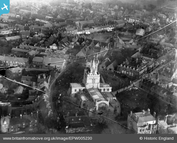
EPW005230 ENGLAND (1921). St Mary's Church and St Mary's Square, Aylesbury, 1921
© Copyright OpenStreetMap contributors and licensed by the OpenStreetMap Foundation. 2026. Cartography is licensed as CC BY-SA.
Nearby Images (9)
Details
| Title | [EPW005230] St Mary's Church and St Mary's Square, Aylesbury, 1921 |
| Reference | EPW005230 |
| Date | January-1921 |
| Link | |
| Place name | AYLESBURY |
| Parish | AYLESBURY |
| District | |
| Country | ENGLAND |
| Easting / Northing | 481721, 213920 |
| Longitude / Latitude | -0.81429073656166, 51.817478818306 |
| National Grid Reference | SP817139 |
Pins

southallboy |
Monday 22nd of October 2012 03:29:48 PM | |

Carolinem |
Wednesday 12th of September 2012 10:30:25 PM | |

Carolinem |
Wednesday 12th of September 2012 05:51:49 PM | |

Carolinem |
Wednesday 12th of September 2012 05:13:19 PM |


![[EPW005230] St Mary's Church and St Mary's Square, Aylesbury, 1921](http://britainfromabove.org.uk/sites/all/libraries/aerofilms-images/public/100x100/EPW/005/EPW005230.jpg)
![[EPW010570] St Mary's Church and the town, Aylesbury, 1924. This image has been produced from a copy-negative.](http://britainfromabove.org.uk/sites/all/libraries/aerofilms-images/public/100x100/EPW/010/EPW010570.jpg)
![[EPW005587] St Mary's Church and The Prebendal, Aylesbury, 1921. This image has been produced from a damaged copy-negative.](http://britainfromabove.org.uk/sites/all/libraries/aerofilms-images/public/100x100/EPW/005/EPW005587.jpg)
![[EPW005585] St Mary's Church, Aylesbury, 1921. This image has been produced from a copy-negative.](http://britainfromabove.org.uk/sites/all/libraries/aerofilms-images/public/100x100/EPW/005/EPW005585.jpg)
![[EPW005589] The town centre, Aylesbury, 1921. This image has been produced from a copy-negative.](http://britainfromabove.org.uk/sites/all/libraries/aerofilms-images/public/100x100/EPW/005/EPW005589.jpg)
![[EAW009508] The town centre, Aylesbury, 1947](http://britainfromabove.org.uk/sites/all/libraries/aerofilms-images/public/100x100/EAW/009/EAW009508.jpg)
![[EPW005231] The Market Square and Clock Tower, Aylesbury, 1921](http://britainfromabove.org.uk/sites/all/libraries/aerofilms-images/public/100x100/EPW/005/EPW005231.jpg)
![[EPW005232] The Market Square and Clock Tower, Aylesbury, 1921](http://britainfromabove.org.uk/sites/all/libraries/aerofilms-images/public/100x100/EPW/005/EPW005232.jpg)
![[EAW004150] The Market Square, Aylesbury, 1947](http://britainfromabove.org.uk/sites/all/libraries/aerofilms-images/public/100x100/EAW/004/EAW004150.jpg)