
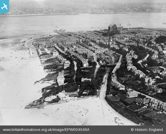
EPW004049A ENGLAND (1920). General view of the town and The Tower, New Brighton, 1920
© Copyright OpenStreetMap contributors and licensed by the OpenStreetMap Foundation. 2026. Cartography is licensed as CC BY-SA.
Nearby Images (3)
EPW004049A

EPW045208

EPW004046

Details
| Title | [EPW004049A] General view of the town and The Tower, New Brighton, 1920 |
| Reference | EPW004049A |
| Date | August-1920 |
| Link | |
| Place name | NEW BRIGHTON |
| Parish | |
| District | |
| Country | ENGLAND |
| Easting / Northing | 330278, 393988 |
| Longitude / Latitude | -3.0496810034155, 53.437795333851 |
| National Grid Reference | SJ303940 |
Pins
Be the first to add a comment to this image!
User Comment Contributions
Another shot with the Tower erased. |

mannidaze |
Saturday 12th of January 2013 01:54:11 PM |
New Brighton has changed so much. In this picture the railway track runs down towards the camera and then along the edge of the beach. Today the train track is in the same place but the beach is about half a mile away. |
BruceR |
Monday 5th of November 2012 10:36:31 PM |