
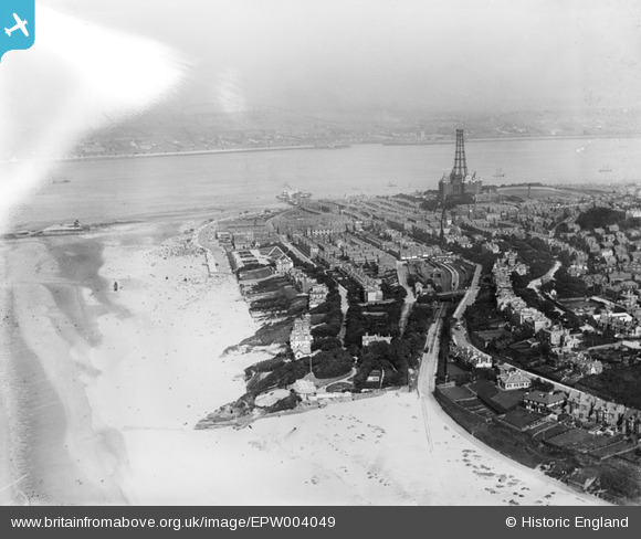
EPW004049 ENGLAND (1920). General view of the town and The Tower, New Brighton, 1920
© Copyright OpenStreetMap contributors and licensed by the OpenStreetMap Foundation. 2026. Cartography is licensed as CC BY-SA.
Nearby Images (8)
EPW004049

EPW050655

EPW004057

EPW004056

EPW050656

EPW045205

EPW045206

EPW004048

Details
| Title | [EPW004049] General view of the town and The Tower, New Brighton, 1920 |
| Reference | EPW004049 |
| Date | August-1920 |
| Link | |
| Place name | NEW BRIGHTON |
| Parish | |
| District | |
| Country | ENGLAND |
| Easting / Northing | 330560, 394049 |
| Longitude / Latitude | -3.045449663142, 53.438380831522 |
| National Grid Reference | SJ306940 |
Pins

Ginger79 |
Saturday 27th of March 2021 10:04:04 PM | |

Bunn72 |
Saturday 28th of November 2015 08:50:11 PM | |
|
Bob Fraser |
Sunday 2nd of August 2015 09:00:47 PM | |
|
Bob Fraser |
Sunday 2nd of August 2015 08:59:58 PM | |
|
Bob Fraser |
Sunday 2nd of August 2015 08:59:25 PM | |
The tower was constructed c1899 and dismnantled c1920 due to neglect during WW1. So this image would be during demolition not construction. |
Saul Kevin |
Monday 16th of November 2015 03:53:11 AM |
|
Pete65 |
Sunday 23rd of February 2014 03:21:19 AM | |
|
Bob Fraser |
Monday 20th of January 2014 01:38:03 PM | |
|
BruceR |
Friday 19th of October 2012 10:36:34 PM |
