
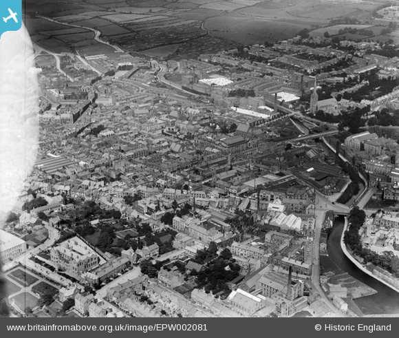
EPW002081 ENGLAND (1920). The city centre, Lancaster, 1920
© Copyright OpenStreetMap contributors and licensed by the OpenStreetMap Foundation. 2026. Cartography is licensed as CC BY-SA.
Nearby Images (9)
EPW002081

EPW002087

EPW029176

EPW029183

EPW042038

EPW002084

EPW042037

EPW026406

EPW029182

Details
| Title | [EPW002081] The city centre, Lancaster, 1920 |
| Reference | EPW002081 |
| Date | July-1920 |
| Link | |
| Place name | LANCASTER |
| Parish | |
| District | |
| Country | ENGLAND |
| Easting / Northing | 347786, 461499 |
| Longitude / Latitude | -2.7975341196106, 54.046625366468 |
| National Grid Reference | SD478615 |
Pins

Kar |
Wednesday 7th of August 2019 08:23:09 PM | |

Class31 |
Tuesday 11th of August 2015 08:39:13 AM | |
|
Class31 |
Tuesday 11th of August 2015 08:36:44 AM | |
|
Class31 |
Tuesday 11th of August 2015 08:36:00 AM | |
|
Class31 |
Tuesday 11th of August 2015 08:34:04 AM | |
|
steve |
Saturday 15th of February 2014 06:57:15 PM | |
|
I B |
Wednesday 6th of November 2013 10:11:47 PM | |
|
I B |
Wednesday 6th of November 2013 10:03:11 PM | |
|
Skerald |
Monday 22nd of July 2013 10:40:11 PM | |
|
Skerald |
Monday 22nd of July 2013 10:39:13 PM | |
|
Skerald |
Monday 22nd of July 2013 10:36:33 PM | |
|
Skerald |
Monday 22nd of July 2013 10:35:04 PM |


User Comment Contributions
Dalton Square, Lancaster, 16/07/2015 |
Class31 |
Tuesday 11th of August 2015 08:34:46 AM |
The Ashton Memorial is not, in fact, on this photo, it would be to the top right of this area |
stuart |
Monday 2nd of July 2012 01:28:56 PM |
I don't think so! The Town Hall is the large building in the centre, built by Lord Ashton. |
senojdet |
Sunday 1st of July 2012 08:17:46 PM |