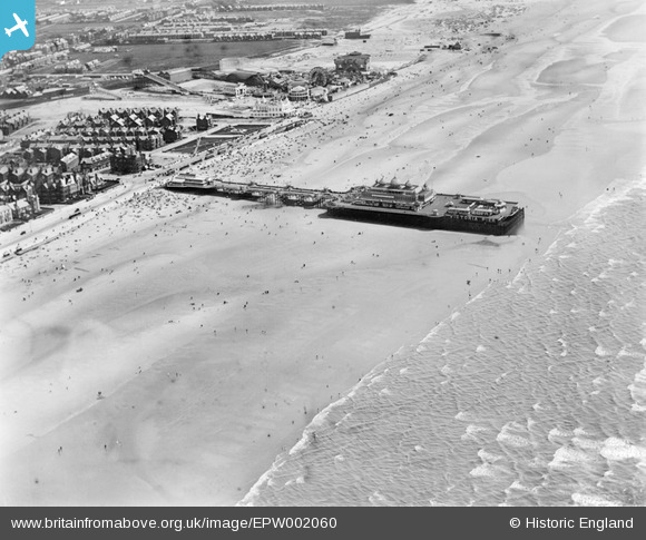
EPW002060 ENGLAND (1920). The Victoria Pier, Blackpool, 1920
© Copyright OpenStreetMap contributors and licensed by the OpenStreetMap Foundation. 2026. Cartography is licensed as CC BY-SA.
Nearby Images (7)
Details
| Title | [EPW002060] The Victoria Pier, Blackpool, 1920 |
| Reference | EPW002060 |
| Date | July-1920 |
| Link | |
| Place name | BLACKPOOL |
| Parish | |
| District | |
| Country | ENGLAND |
| Easting / Northing | 330330, 433839 |
| Longitude / Latitude | -3.0578151886622, 53.79597364256 |
| National Grid Reference | SD303338 |
Pins

Carl R |
Thursday 24th of July 2014 01:28:09 PM |
User Comment Contributions
WOW! |

SteveAUS |
Wednesday 27th of June 2012 10:23:36 AM |


![[EPW002060] The Victoria Pier, Blackpool, 1920](http://britainfromabove.org.uk/sites/all/libraries/aerofilms-images/public/100x100/EPW/002/EPW002060.jpg)
![[EPW002075] The Victoria Pier, Blackpool, 1920](http://britainfromabove.org.uk/sites/all/libraries/aerofilms-images/public/100x100/EPW/002/EPW002075.jpg)
![[EPW038742] The sea front, Blackpool, from the south-west, 1932. This image has been produced from a damaged negative.](http://britainfromabove.org.uk/sites/all/libraries/aerofilms-images/public/100x100/EPW/038/EPW038742.jpg)
![[EPW038741] South Shore Baths, Blackpool, 1932](http://britainfromabove.org.uk/sites/all/libraries/aerofilms-images/public/100x100/EPW/038/EPW038741.jpg)
![[EAW020133] The Open Air Swimming Bath, Blackpool, 1948. This image has been produced from a print.](http://britainfromabove.org.uk/sites/all/libraries/aerofilms-images/public/100x100/EAW/020/EAW020133.jpg)
![[EAW023419] The Open Air Swimming Bath, Blackpool, 1949](http://britainfromabove.org.uk/sites/all/libraries/aerofilms-images/public/100x100/EAW/023/EAW023419.jpg)
![[EPW029209] The Open Air Swimming Baths and Victoria Pier, Blackpool, 1929](http://britainfromabove.org.uk/sites/all/libraries/aerofilms-images/public/100x100/EPW/029/EPW029209.jpg)
