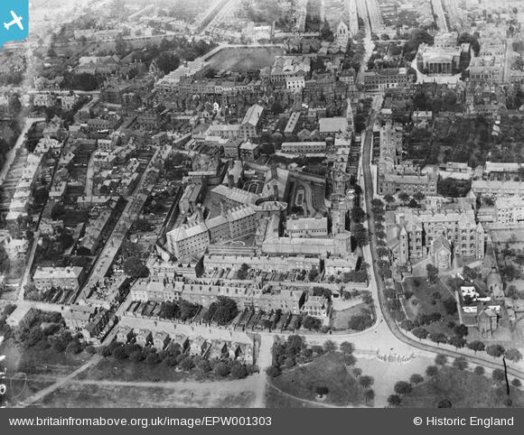
EPW001303 ENGLAND (1920). The City and County Prison, Worcester, 1920
© Copyright OpenStreetMap contributors and licensed by the OpenStreetMap Foundation. 2026. Cartography is licensed as CC BY-SA.
Details
| Title | [EPW001303] The City and County Prison, Worcester, 1920 |
| Reference | EPW001303 |
| Date | May-1920 |
| Link | |
| Place name | WORCESTER |
| Parish | |
| District | |
| Country | ENGLAND |
| Easting / Northing | 384633, 255400 |
| Longitude / Latitude | -2.2248498971648, 52.196218481917 |
| National Grid Reference | SO846554 |
Pins

Sue43 |
Friday 3rd of November 2023 02:36:15 PM | |

Class31 |
Monday 9th of February 2015 10:25:08 AM | |

Class31 |
Monday 9th of February 2015 10:22:35 AM | |

Class31 |
Monday 9th of February 2015 09:26:57 AM | |

Class31 |
Monday 9th of February 2015 09:21:33 AM | |

Class31 |
Monday 9th of February 2015 09:16:46 AM | |

Class31 |
Monday 9th of February 2015 09:07:30 AM | |

Class31 |
Monday 9th of February 2015 09:05:13 AM | |

Brian Humphreys |
Thursday 13th of November 2014 08:23:45 AM | |

Brian Humphreys |
Thursday 13th of November 2014 08:22:48 AM |
User Comment Contributions
Worcester Royal Infirmary now part of Worcester University, Worcester, 08/02/2015 |

Class31 |
Monday 9th of February 2015 10:27:18 AM |
The Shirehall, Worcester, 08/02/2015 |

Class31 |
Monday 9th of February 2015 08:58:13 AM |
Worcester Royal Infirmary now part of Worcester University, Worcester, 08/02/2015 |

Class31 |
Monday 9th of February 2015 08:56:54 AM |


![[EPW001303] The City and County Prison, Worcester, 1920](http://britainfromabove.org.uk/sites/all/libraries/aerofilms-images/public/100x100/EPW/001/EPW001303.jpg)
![[EPW000210] Worcester Prison, Castle Street, Worcester, 1920](http://britainfromabove.org.uk/sites/all/libraries/aerofilms-images/public/100x100/EPW/000/EPW000210.jpg)
![[EPW005384A] Castle Street and environs, Worcester, from the south-west, 1921](http://britainfromabove.org.uk/sites/all/libraries/aerofilms-images/public/100x100/EPW/005/EPW005384A.jpg)
![[EPW000200] Castle Street Prison, Worcester, 1920](http://britainfromabove.org.uk/sites/all/libraries/aerofilms-images/public/100x100/EPW/000/EPW000200.jpg)