
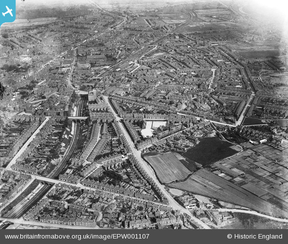
EPW001107 ENGLAND (1920). General view of central West Bromwich, West Bromwich, 1920
© Copyright OpenStreetMap contributors and licensed by the OpenStreetMap Foundation. 2026. Cartography is licensed as CC BY-SA.
Nearby Images (19)
EPW001107

EAW002842
 Works on Moor Street and environs, West Bromwich, 1946")
EAW033507
 Works, West Bromwich, 1950. This image was marked by Aerofilms Ltd for photo editing.")
EAW033508
 Works and environs, West Bromwich, 1950. This image was marked by Aerofilms Ltd for photo editing.")
EAW033510
 Works, West Bromwich, 1950. This image was marked by Aerofilms Ltd for photo editing.")
EAW002844
 Works on Moor Street and environs, West Bromwich, 1946")
EAW002841
 Works on Moor Street and environs, West Bromwich, from the south, 1946")
EAW033511
 Works and environs, West Bromwich, 1950. This image was marked by Aerofilms Ltd for photo editing.")
EAW033512
 Works and environs, West Bromwich, 1950. This image was marked by Aerofilms Ltd for photo editing.")
EAW033506
 Works and environs, West Bromwich, 1950. This image was marked by Aerofilms Ltd for photo editing.")
EAW002845
 Works on Moor Street and environs, West Bromwich, 1946")
EAW033509
 Works and environs, West Bromwich, 1950. This image was marked by Aerofilms Ltd for photo editing.")
EPW053758

EAW033505
 Works, West Bromwich, 1950. This image was marked by Aerofilms Ltd for photo editing.")
EPW001100

EPW053761

EPW053759

EPW053756

EPW053760

Details
| Title | [EPW001107] General view of central West Bromwich, West Bromwich, 1920 |
| Reference | EPW001107 |
| Date | May-1920 |
| Link | |
| Place name | WEST BROMWICH |
| Parish | |
| District | |
| Country | ENGLAND |
| Easting / Northing | 399994, 291078 |
| Longitude / Latitude | -2.0000884303408, 52.517220567655 |
| National Grid Reference | SO1000911 |
Pins

Cyril Squid |
Sunday 11th of May 2025 10:21:01 PM | |
|
DaveT |
Sunday 29th of December 2024 02:18:32 PM | |
|
DaveT |
Sunday 29th of December 2024 02:17:07 PM | |
|
DaveT |
Sunday 29th of December 2024 02:15:10 PM | |
|
DaveT |
Sunday 29th of December 2024 02:14:35 PM | |
|
DaveT |
Sunday 29th of December 2024 02:12:44 PM | |
|
DaveT |
Sunday 29th of December 2024 02:10:18 PM | |
|
DaveT |
Sunday 29th of December 2024 02:09:07 PM | |
|
DaveT |
Sunday 29th of December 2024 02:04:46 PM | |
 |
DaveT |
Sunday 29th of December 2024 02:02:09 PM |
|
DaveT |
Sunday 29th of December 2024 01:52:17 PM | |
|
DaveT |
Sunday 29th of December 2024 01:51:26 PM | |
|
DaveT |
Sunday 29th of December 2024 01:45:15 PM | |
|
DaveT |
Sunday 20th of April 2014 09:33:29 AM | |
|
DaveT |
Saturday 19th of October 2013 04:20:26 AM | |
|
DaveT |
Saturday 19th of October 2013 03:58:54 AM | |
|
DaveT |
Tuesday 15th of October 2013 02:40:18 PM | |
|
DaveT |
Tuesday 15th of October 2013 02:12:15 PM | |
|
Steve Williams |
Wednesday 25th of July 2012 08:02:56 PM | |
|
Steve Williams |
Wednesday 25th of July 2012 08:01:45 PM | |
|
Lou789 |
Friday 13th of July 2012 10:50:20 PM | |
|
Lou789 |
Friday 13th of July 2012 10:46:15 PM | |
|
Lou789 |
Friday 13th of July 2012 10:43:29 PM | |
Barton Street was originally called Old End, which was a settlement on the edge of West Bromwich Heath before enclosure in 1801. It threads its way towards Oak House and many of the old houses were cleared in the 1920's as part of slum clearance. "Some clearance was carried out under the WestBromwich Corporation Act of 1913. (fn. 32) After thepassing of the 1919 Housing Act the corporation scheduled nearly 2,900 houses as unfit, but by 1933 only 346 had been demolished, chiefly in Barton Street (in the former Old End area) and Swan Village. From: 'West Bromwich: Public services', A History of the County of Stafford: Volume 17: Offlow hundred (part) (1976), pp. 46-50. URL: http://www.british-history.ac.uk/report.aspx Date accessed: 15 October 2013. |
DaveT |
Tuesday 15th of October 2013 02:04:40 PM |
Barton Street was originally called Old End, which was a settlement on the edge of West Bromwich Heath before enclosure in 1801. It threads its way towards Oak House and many of the old houses were cleared in the 1920's as part of slum clearance. "Some clearance was carried out under the WestBromwich Corporation Act of 1913. (fn. 32) After thepassing of the 1919 Housing Act the corporation scheduled nearly 2,900 houses as unfit, but by 1933 only 346 had been demolished, chiefly in Barton Street (in the former Old End area) and Swan Village. From: 'West Bromwich: Public services', A History of the County of Stafford: Volume 17: Offlow hundred (part) (1976), pp. 46-50. URL: http://www.british-history.ac.uk/report.aspx Date accessed: 15 October 2013. |
DaveT |
Tuesday 15th of October 2013 02:04:47 PM |
|
Lou789 |
Friday 13th of July 2012 10:42:38 PM | |
|
Steve Cemm |
Tuesday 10th of July 2012 08:17:04 PM | |
|
Steve Cemm |
Tuesday 10th of July 2012 08:16:20 PM | |
|
Steve Cemm |
Tuesday 10th of July 2012 08:15:31 PM | |
|
Steve Cemm |
Tuesday 10th of July 2012 08:14:47 PM | |
|
Stevie Flower |
Wednesday 27th of June 2012 09:56:59 PM | |
|
Stevie Flower |
Wednesday 27th of June 2012 09:55:34 PM | |
|
Stevie Flower |
Wednesday 27th of June 2012 09:53:21 PM |