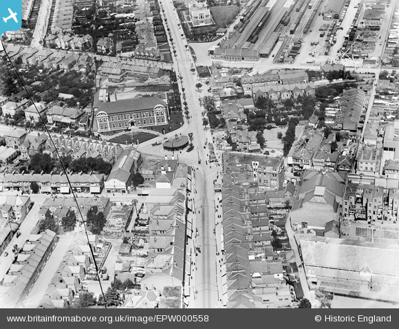
EPW000558 ENGLAND (1920). Victoria Circus, Southend-on-Sea, 1920
© Copyright OpenStreetMap contributors and licensed by the OpenStreetMap Foundation. 2026. Cartography is licensed as CC BY-SA.
Nearby Images (5)
Details
| Title | [EPW000558] Victoria Circus, Southend-on-Sea, 1920 |
| Reference | EPW000558 |
| Date | April-1920 |
| Link | |
| Place name | SOUTHEND-ON-SEA |
| Parish | |
| District | |
| Country | ENGLAND |
| Easting / Northing | 588152, 185844 |
| Longitude / Latitude | 0.71346796295216, 51.539608473167 |
| National Grid Reference | TQ882858 |
Pins

Mart |
Friday 22nd of June 2018 07:16:58 PM | |

Kollage Kid |
Monday 22nd of April 2013 05:00:14 PM | |

EZTD |
Tuesday 3rd of July 2012 09:50:34 PM | |

EZTD |
Tuesday 3rd of July 2012 09:49:54 PM | |

EZTD |
Tuesday 3rd of July 2012 09:49:10 PM | |

EZTD |
Tuesday 3rd of July 2012 01:38:54 PM | |

EZTD |
Tuesday 3rd of July 2012 01:34:24 PM | |

EZTD |
Tuesday 3rd of July 2012 01:33:53 PM | |

EZTD |
Tuesday 3rd of July 2012 01:33:09 PM |


![[EPW000558] Victoria Circus, Southend-on-Sea, 1920](http://britainfromabove.org.uk/sites/all/libraries/aerofilms-images/public/100x100/EPW/000/EPW000558.jpg)
![[EPW000557] Victoria Circus, Southend-on-Sea, 1920](http://britainfromabove.org.uk/sites/all/libraries/aerofilms-images/public/100x100/EPW/000/EPW000557.jpg)
![[EPW024891] The Technical School, Victoria Circus and environs, Southend-on-Sea, 1928](http://britainfromabove.org.uk/sites/all/libraries/aerofilms-images/public/100x100/EPW/024/EPW024891.jpg)
![[EPW000548] Municipal College, Southend-on-Sea, 1920](http://britainfromabove.org.uk/sites/all/libraries/aerofilms-images/public/100x100/EPW/000/EPW000548.jpg)
![[EPW000560] Warrior Square, Southend-on-Sea, from the south-east, 1920](http://britainfromabove.org.uk/sites/all/libraries/aerofilms-images/public/100x100/EPW/000/EPW000560.jpg)