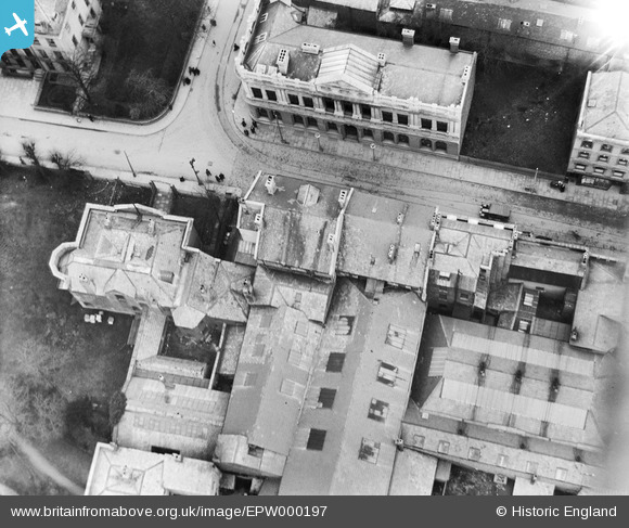
EPW000197 ENGLAND (1920). The junction of North Street and Albion Street, Cheltenham, 1920
© Copyright OpenStreetMap contributors and licensed by the OpenStreetMap Foundation. 2026. Cartography is licensed as CC BY-SA.
Nearby Images (5)
Details
| Title | [EPW000197] The junction of North Street and Albion Street, Cheltenham, 1920 |
| Reference | EPW000197 |
| Date | February-1920 |
| Link | |
| Place name | CHELTENHAM |
| Parish | |
| District | |
| Country | ENGLAND |
| Easting / Northing | 394978, 222586 |
| Longitude / Latitude | -2.0729997882367, 51.901357540622 |
| National Grid Reference | SO950226 |
Pins

Class31 |
Monday 6th of August 2012 02:37:23 PM | |

Class31 |
Monday 6th of August 2012 02:36:16 PM | |

Class31 |
Monday 6th of August 2012 02:34:43 PM | |

Class31 |
Monday 6th of August 2012 02:32:30 PM | |

Class31 |
Monday 6th of August 2012 02:28:47 PM | |

Class31 |
Monday 6th of August 2012 02:26:05 PM |
User Comment Contributions
Albion Street north side 27/09/2013 |

Class31 |
Sunday 29th of September 2013 08:21:05 PM |
Albion House now Albion House Social Club looking north west 27/09/2013 |

Class31 |
Sunday 29th of September 2013 08:19:46 PM |
Dear all, Thanks for your help; we've reviewed the pins and suggestions and thanks to your help we can update the catalogue. The revised record will appear here in due course. Yours, Katy Britain from Above Cataloguing Team Leader |
Katy Whitaker |
Tuesday 23rd of October 2012 09:16:25 AM |
Surely the building tagged as Albion Street Social Club is, in fact, The Liberal Club? |

Trebor |
Saturday 20th of October 2012 03:29:12 PM |
View is looking east with the junction of North Place, North Road and Albion Street in centre of view. Albion House is a grade 2 listed building with a unique footprint when seen from above. The building on the Albion Street and North Place corner is still in situ. The other buildings in the photo have changed. The tramlines assisted identification. Primark and Jobcentreplus are now found on the west side of North Street. |

Class31 |
Monday 6th of August 2012 02:46:03 PM |
Yes, I think sussex brook is correct. check this location http://goo.gl/maps/FZZj and see how the Lib Dem club is the same building on the west side of North street. |

webgenius |
Tuesday 10th of July 2012 04:44:07 PM |
This is the old Gas Co offices in North Street / Place. Opposite is the Liberal Club, the old Drill Hall and (the roof of) Wards department store. To the right would be Boots the Chemists. Both sides of the road have been redeveloped out of all recognition.The tram tracks are turning into Albion Street. |

Sussex Brook |
Saturday 7th of July 2012 03:54:09 PM |
I just think that this might be Cheltenham. Perhaps someone who knows Cheltenham could think if it fits. Just a Punt. |

Class31 |
Wednesday 4th of July 2012 06:45:19 PM |


![[EPW000197] The junction of North Street and Albion Street, Cheltenham, 1920](http://britainfromabove.org.uk/sites/all/libraries/aerofilms-images/public/100x100/EPW/000/EPW000197.jpg)
![[EPW000198] E.L. Ward and Boots the Chemist, High Street, Cheltenham, 1920](http://britainfromabove.org.uk/sites/all/libraries/aerofilms-images/public/100x100/EPW/000/EPW000198.jpg)
![[EPW000169] St Mary's Church, Cheltenham, 1920](http://britainfromabove.org.uk/sites/all/libraries/aerofilms-images/public/100x100/EPW/000/EPW000169.jpg)
![[EAW006882] The High Street and the town centre, Cheltenham, 1947](http://britainfromabove.org.uk/sites/all/libraries/aerofilms-images/public/100x100/EAW/006/EAW006882.jpg)
![[EPW000196] Lloyds Bank, High Street, Cheltenham, 1920](http://britainfromabove.org.uk/sites/all/libraries/aerofilms-images/public/100x100/EPW/000/EPW000196.jpg)