
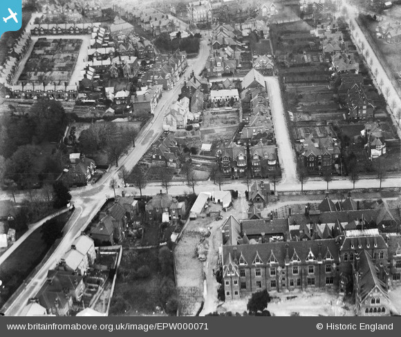
EPW000071 ENGLAND (1920). Darley Road and environs, Eastbourne, 1920
© Copyright OpenStreetMap contributors and licensed by the OpenStreetMap Foundation. 2026. Cartography is licensed as CC BY-SA.
Nearby Images (2)
EPW000071

EPW039404

Details
| Title | [EPW000071] Darley Road and environs, Eastbourne, 1920 |
| Reference | EPW000071 |
| Date | February-1920 |
| Link | |
| Place name | EASTBOURNE |
| Parish | |
| District | |
| Country | ENGLAND |
| Easting / Northing | 560090, 97503 |
| Longitude / Latitude | 0.26984973239623, 50.754447343797 |
| National Grid Reference | TV601975 |
Pins

Mikeo1938 |
Thursday 13th of July 2017 06:59:39 PM | |
|
Mikeo1938 |
Friday 10th of October 2014 10:22:26 PM | |
|
Mikeo1938 |
Monday 2nd of July 2012 01:38:58 PM | |
|
Mikeo1938 |
Monday 2nd of July 2012 01:38:13 PM |
User Comment Contributions
Dear all, That’s great; we’ve reviewed your suggestions and thanks to your help we can update the catalogue. The revised record will appear here in due course. Hope you have the same success solving some of our other mysteries! Katy Whitaker Britain from Above Cataloguer |
Katy Whitaker |
Monday 2nd of July 2012 12:02:00 PM |
I believe the building on the lower right is the old All Saints Hospital, the majority of which still exists as modern apartments,and Meads Street is on the left. |
Jeremy Dixon |
Sunday 1st of July 2012 12:33:35 AM |
Agreed |
Andy Cole |
Monday 25th of June 2012 11:57:28 PM |
Also agreed. Definitely Meads St. and Darley Rd. in Meads in Eastbourne. |
former user |
Sunday 1st of July 2012 12:33:35 AM |
This is a wonderful photograph showing several buildings which have disappeared over the years. The large building in the foreground is indeed All Saints. The flint cottages with partially tile-hung walls at the corner of Darley Road and Meads Street were for the staff of the hospital and are well documented in various photographs. More interesting are the Ships Cottages (demolished c. 1950s) which were reached via the twitten behind the Ship and also from Meads Street. The large pitched roof to the right of these cottages was that of the former gymnasium run by a Mr Moss – this was used by many of the smaller private schools which did not have such facilities: after WW2 these premises became a shirt factory. At the corner of Meads Street and Matlock Road, partially hidden by trees, can be seen the white rendered walls of Sprays Farmhouse, which was demolished in October 1921. The lane which runs behind the farmhouse (now behind nos 24 – 34 Meads Street) can clearly be seen, as can a large building with white double doors. This was stables but in later years became garages with the upper part a store for the scenery of the Clarkson Rose shows at the Devonshire Park. |
Mikeo1938 |
Wednesday 27th of June 2012 09:27:34 AM |