
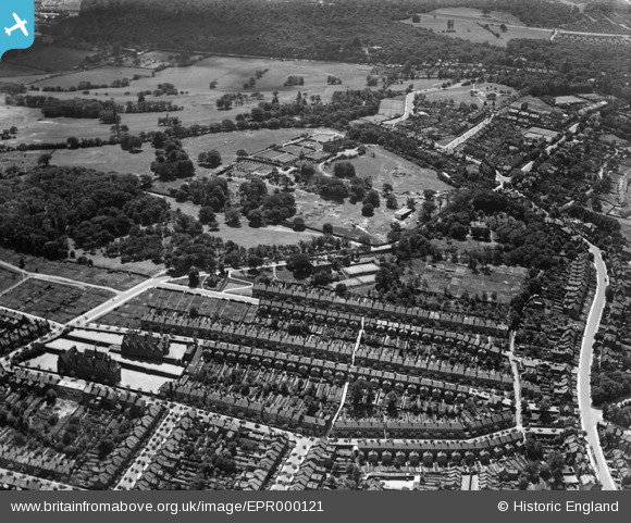
EPR000121 ENGLAND (1934). Nithdale Road, Shrewsbury Park and environs, Shooters Hill, 1934
© Copyright OpenStreetMap contributors and licensed by the OpenStreetMap Foundation. 2026. Cartography is licensed as CC BY-SA.
Nearby Images (4)
EPR000121

EPR000214

EPR000126

EPR000124

Details
| Title | [EPR000121] Nithdale Road, Shrewsbury Park and environs, Shooters Hill, 1934 |
| Reference | EPR000121 |
| Date | 4-July-1934 |
| Link | |
| Place name | SHOOTERS HILL |
| Parish | |
| District | |
| Country | ENGLAND |
| Easting / Northing | 544048, 177292 |
| Longitude / Latitude | 0.074437838536754, 51.47573800722 |
| National Grid Reference | TQ440773 |
Pins

John W |
Sunday 1st of May 2016 11:37:16 AM | |
|
John W |
Sunday 1st of May 2016 11:36:11 AM | |
|
John W |
Sunday 1st of May 2016 11:35:09 AM | |
|
John W |
Sunday 1st of May 2016 11:33:38 AM | |
|
John W |
Sunday 1st of May 2016 11:32:13 AM | |
|
John W |
Sunday 1st of May 2016 11:30:05 AM | |
|
John W |
Sunday 1st of May 2016 11:29:22 AM | |
|
John W |
Sunday 1st of May 2016 11:28:45 AM | |
|
John W |
Sunday 1st of May 2016 11:28:14 AM | |
|
John W |
Sunday 1st of May 2016 11:27:43 AM | |
|
John W |
Sunday 1st of May 2016 11:26:44 AM | |
|
John W |
Sunday 1st of May 2016 11:26:14 AM |