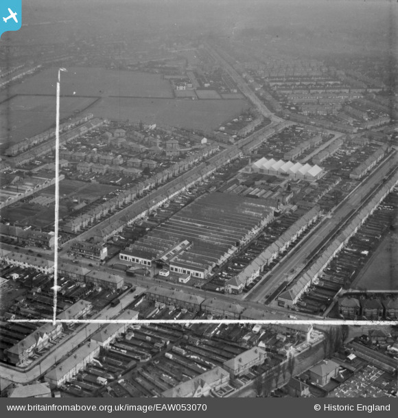
EAW053070 ENGLAND (1954). Smith Meters Ltd Works on Rowan Road and environs, Mitcham, 1954. This image was marked by Aerofilms Ltd for photo editing.
© Copyright OpenStreetMap contributors and licensed by the OpenStreetMap Foundation. 2026. Cartography is licensed as CC BY-SA.
Nearby Images (24)
Details
| Title | [EAW053070] Smith Meters Ltd Works on Rowan Road and environs, Mitcham, 1954. This image was marked by Aerofilms Ltd for photo editing. |
| Reference | EAW053070 |
| Date | 4-January-1954 |
| Link | |
| Place name | MITCHAM |
| Parish | |
| District | |
| Country | ENGLAND |
| Easting / Northing | 529503, 169487 |
| Longitude / Latitude | -0.13775536404627, 51.409105311775 |
| National Grid Reference | TQ295695 |
Pins
Be the first to add a comment to this image!


![[EAW053070] Smith Meters Ltd Works on Rowan Road and environs, Mitcham, 1954. This image was marked by Aerofilms Ltd for photo editing.](http://britainfromabove.org.uk/sites/all/libraries/aerofilms-images/public/100x100/EAW/053/EAW053070.jpg)
![[EAW053069] Smith Meters Ltd Works on Rowan Road, Mitcham, 1954. This image was marked by Aerofilms Ltd for photo editing.](http://britainfromabove.org.uk/sites/all/libraries/aerofilms-images/public/100x100/EAW/053/EAW053069.jpg)
![[EAW007253] Smith Meters Ltd Works on Rowan Road, Mitcham, 1947](http://britainfromabove.org.uk/sites/all/libraries/aerofilms-images/public/100x100/EAW/007/EAW007253.jpg)
![[EAW007255] Smith Meters Ltd Works on Rowan Road, Mitcham, 1947](http://britainfromabove.org.uk/sites/all/libraries/aerofilms-images/public/100x100/EAW/007/EAW007255.jpg)
![[EAW053071] Smith Meters Ltd Works on Rowan Road and environs, Mitcham, 1954. This image was marked by Aerofilms Ltd for photo editing.](http://britainfromabove.org.uk/sites/all/libraries/aerofilms-images/public/100x100/EAW/053/EAW053071.jpg)
![[EAW053068] Smith Meters Ltd Works on Rowan Road, Mitcham, 1954. This image was marked by Aerofilms Ltd for photo editing.](http://britainfromabove.org.uk/sites/all/libraries/aerofilms-images/public/100x100/EAW/053/EAW053068.jpg)
![[EAW007250] Smith Meters Ltd Works, Mitcham, 1947](http://britainfromabove.org.uk/sites/all/libraries/aerofilms-images/public/100x100/EAW/007/EAW007250.jpg)
![[EAW053066] Smith Meters Ltd Works on Rowan Road, Mitcham, 1954. This image was marked by Aerofilms Ltd for photo editing.](http://britainfromabove.org.uk/sites/all/libraries/aerofilms-images/public/100x100/EAW/053/EAW053066.jpg)
![[EAW007249] Smith Meters Ltd Works on Rowan Road, Mitcham, 1947](http://britainfromabove.org.uk/sites/all/libraries/aerofilms-images/public/100x100/EAW/007/EAW007249.jpg)
![[EAW007248] Smith Meters Ltd Works on Rowan Road, Mitcham, 1947](http://britainfromabove.org.uk/sites/all/libraries/aerofilms-images/public/100x100/EAW/007/EAW007248.jpg)
![[EAW007252] Smith Meters Ltd Works on Rowan Road, Mitcham, 1947. This image was marked by Aerofilms Ltd for photo editing.](http://britainfromabove.org.uk/sites/all/libraries/aerofilms-images/public/100x100/EAW/007/EAW007252.jpg)
![[EAW007254] Smith Meters Ltd Works on Rowan Road, Mitcham, 1947](http://britainfromabove.org.uk/sites/all/libraries/aerofilms-images/public/100x100/EAW/007/EAW007254.jpg)
![[EAW053067] Smith Meters Ltd Works on Rowan Road, Mitcham, 1954. This image was marked by Aerofilms Ltd for photo editing.](http://britainfromabove.org.uk/sites/all/libraries/aerofilms-images/public/100x100/EAW/053/EAW053067.jpg)
![[EAW053073] Smith Meters Ltd Works on Rowan Road and environs, Mitcham, from the north-west, 1954. This image was marked by Aerofilms Ltd for photo editing.](http://britainfromabove.org.uk/sites/all/libraries/aerofilms-images/public/100x100/EAW/053/EAW053073.jpg)
![[EAW053072] Smith Meters Ltd Works on Rowan Road and environs, Mitcham, 1954. This image was marked by Aerofilms Ltd for photo editing.](http://britainfromabove.org.uk/sites/all/libraries/aerofilms-images/public/100x100/EAW/053/EAW053072.jpg)
![[EAW007251] Smith Meters Ltd Works and Streatham Park Cemetery, Mitcham, 1947](http://britainfromabove.org.uk/sites/all/libraries/aerofilms-images/public/100x100/EAW/007/EAW007251.jpg)
![[EAW017020] Marco Refrigerators Ltd, Stirling Nurseries and environs, Mitcham, 1948. This image was marked by Aerofilms Ltd for photo editing.](http://britainfromabove.org.uk/sites/all/libraries/aerofilms-images/public/100x100/EAW/017/EAW017020.jpg)
![[EAW017023] Marco Refrigerators Ltd and environs, Mitcham, 1948. This image has been produced from a damaged negative.](http://britainfromabove.org.uk/sites/all/libraries/aerofilms-images/public/100x100/EAW/017/EAW017023.jpg)
![[EAW017019] The Marco Refrigerators Ltd Works and environs, Mitcham, 1948. This image has been produced from a print marked by Aerofilms Ltd for photo editing.](http://britainfromabove.org.uk/sites/all/libraries/aerofilms-images/public/100x100/EAW/017/EAW017019.jpg)
![[EAW017018] The Marco Refrigerators Ltd Works and environs, Mitcham, from the south-west, 1948. This image has been produced from a print.](http://britainfromabove.org.uk/sites/all/libraries/aerofilms-images/public/100x100/EAW/017/EAW017018.jpg)
![[EAW017017] The Marco Refrigerators Ltd Works, Mitcham, 1948. This image has been produced from a print.](http://britainfromabove.org.uk/sites/all/libraries/aerofilms-images/public/100x100/EAW/017/EAW017017.jpg)
![[EAW017016] The Marco Refrigerators Ltd Works, Mitcham, 1948. This image has been produced from a print marked by Aerofilms Ltd for photo editing.](http://britainfromabove.org.uk/sites/all/libraries/aerofilms-images/public/100x100/EAW/017/EAW017016.jpg)
![[EAW017022] Marco Refrigerators Ltd and environs, Mitcham, 1948. This image has been produced from a damaged negative.](http://britainfromabove.org.uk/sites/all/libraries/aerofilms-images/public/100x100/EAW/017/EAW017022.jpg)
![[EAW017021] Marco Refrigerators Ltd and environs, Mitcham, 1948. This image has been produced from a damaged negative.](http://britainfromabove.org.uk/sites/all/libraries/aerofilms-images/public/100x100/EAW/017/EAW017021.jpg)