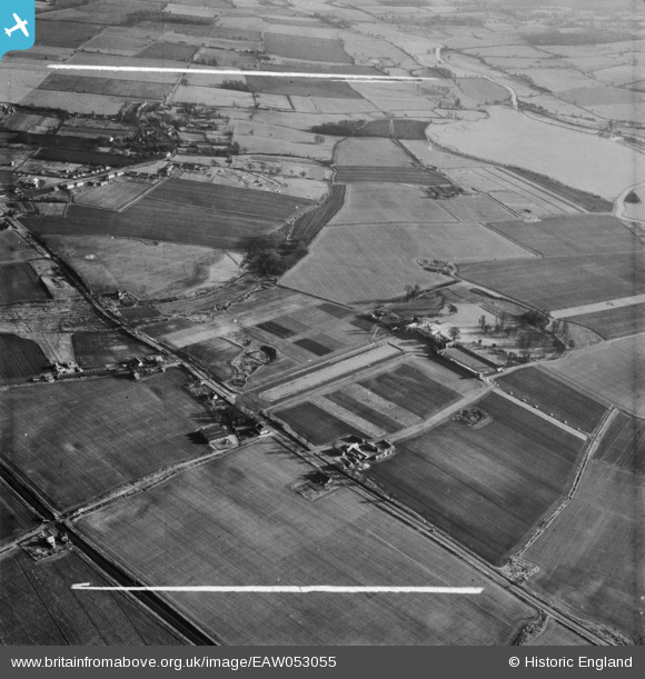
EAW053055 ENGLAND (1954). Boreham House and surrounding countryside, Boreham, 1954. This image was marked by Aerofilms Ltd for photo editing.
© Copyright OpenStreetMap contributors and licensed by the OpenStreetMap Foundation. 2025. Cartography is licensed as CC BY-SA.
Nearby Images (12)
Details
| Title | [EAW053055] Boreham House and surrounding countryside, Boreham, 1954. This image was marked by Aerofilms Ltd for photo editing. |
| Reference | EAW053055 |
| Date | 4-January-1954 |
| Link | |
| Place name | BOREHAM |
| Parish | BOREHAM |
| District | |
| Country | ENGLAND |
| Easting / Northing | 574638, 209290 |
| Longitude / Latitude | 0.53049156805662, 51.754580117155 |
| National Grid Reference | TL746093 |
Pins

Ian |
Saturday 8th of November 2014 10:01:11 AM | |

Ian |
Saturday 8th of November 2014 10:00:36 AM | |

Ian |
Saturday 8th of November 2014 10:00:03 AM | |

Ian |
Sunday 2nd of November 2014 08:32:19 AM | |

Ian |
Sunday 2nd of November 2014 08:31:30 AM | |

Ian |
Sunday 2nd of November 2014 08:30:45 AM | |

Ian |
Sunday 2nd of November 2014 08:29:51 AM | |

Ian |
Sunday 2nd of November 2014 08:29:26 AM | |

Ian |
Sunday 2nd of November 2014 08:28:45 AM | |

Ian |
Sunday 2nd of November 2014 08:27:58 AM | |

Ian |
Sunday 2nd of November 2014 08:27:29 AM | |

Ian |
Sunday 2nd of November 2014 08:27:02 AM | |

Ian |
Sunday 2nd of November 2014 08:26:30 AM | |

Ian |
Sunday 2nd of November 2014 08:24:32 AM | |

Ian |
Sunday 2nd of November 2014 08:24:08 AM |


![[EAW053055] Boreham House and surrounding countryside, Boreham, 1954. This image was marked by Aerofilms Ltd for photo editing.](http://britainfromabove.org.uk/sites/all/libraries/aerofilms-images/public/100x100/EAW/053/EAW053055.jpg)
![[EAW053060] Boreham House and surrounding countryside, Boreham, 1954. This image was marked by Aerofilms Ltd for photo editing.](http://britainfromabove.org.uk/sites/all/libraries/aerofilms-images/public/100x100/EAW/053/EAW053060.jpg)
![[EAW053054] Boreham House and surrounding countryside, Boreham, 1954. This image was marked by Aerofilms Ltd for photo editing.](http://britainfromabove.org.uk/sites/all/libraries/aerofilms-images/public/100x100/EAW/053/EAW053054.jpg)
![[EAW053065] Boreham House and Lake, Boreham, 1954. This image was marked by Aerofilms Ltd for photo editing.](http://britainfromabove.org.uk/sites/all/libraries/aerofilms-images/public/100x100/EAW/053/EAW053065.jpg)
![[EAW053063] Boreham House, Boreham, 1954. This image was marked by Aerofilms Ltd for photo editing.](http://britainfromabove.org.uk/sites/all/libraries/aerofilms-images/public/100x100/EAW/053/EAW053063.jpg)
![[EAW053064] Boreham House and Lake, Boreham, 1954. This image was marked by Aerofilms Ltd for photo editing.](http://britainfromabove.org.uk/sites/all/libraries/aerofilms-images/public/100x100/EAW/053/EAW053064.jpg)
![[EAW053052] Boreham House and surrounding countryside, Boreham, from the west, 1954. This image was marked by Aerofilms Ltd for photo editing.](http://britainfromabove.org.uk/sites/all/libraries/aerofilms-images/public/100x100/EAW/053/EAW053052.jpg)
![[EAW053053] Boreham House and surrounding countryside, Boreham, 1954. This image was marked by Aerofilms Ltd for photo editing.](http://britainfromabove.org.uk/sites/all/libraries/aerofilms-images/public/100x100/EAW/053/EAW053053.jpg)
![[EAW053061] Boreham House, Boreham, 1954. This image was marked by Aerofilms Ltd for photo editing.](http://britainfromabove.org.uk/sites/all/libraries/aerofilms-images/public/100x100/EAW/053/EAW053061.jpg)
![[EAW053062] Boreham House, Boreham, 1954. This image was marked by Aerofilms Ltd for photo editing.](http://britainfromabove.org.uk/sites/all/libraries/aerofilms-images/public/100x100/EAW/053/EAW053062.jpg)
![[EAW053058] Boreham House and grounds, Boreham, 1954. This image was marked by Aerofilms Ltd for photo editing.](http://britainfromabove.org.uk/sites/all/libraries/aerofilms-images/public/100x100/EAW/053/EAW053058.jpg)
![[EAW053059] Boreham House and surrounding countryside, Boreham, from the west, 1954. This image was marked by Aerofilms Ltd for photo editing.](http://britainfromabove.org.uk/sites/all/libraries/aerofilms-images/public/100x100/EAW/053/EAW053059.jpg)