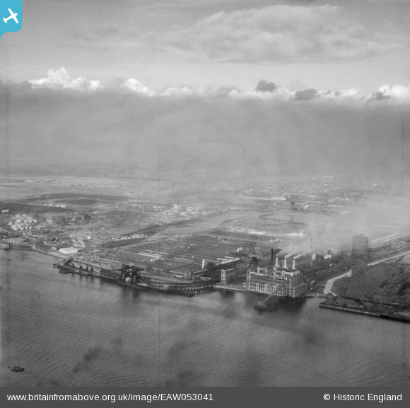
EAW053041 ENGLAND (1953). The Ford Motor Car Manufactory, Dagenham, from the south-east, 1953
© Copyright OpenStreetMap contributors and licensed by the OpenStreetMap Foundation. 2026. Cartography is licensed as CC BY-SA.
Nearby Images (29)
Details
| Title | [EAW053041] The Ford Motor Car Manufactory, Dagenham, from the south-east, 1953 |
| Reference | EAW053041 |
| Date | 24-December-1953 |
| Link | |
| Place name | DAGENHAM |
| Parish | |
| District | |
| Country | ENGLAND |
| Easting / Northing | 549716, 181362 |
| Longitude / Latitude | 0.15772857144635, 51.510839829362 |
| National Grid Reference | TQ497814 |
Pins
Be the first to add a comment to this image!


![[EAW053041] The Ford Motor Car Manufactory, Dagenham, from the south-east, 1953](http://britainfromabove.org.uk/sites/all/libraries/aerofilms-images/public/100x100/EAW/053/EAW053041.jpg)
![[EAW022778] The Ford Motor Company Works, Dagenham, from the south-east, 1949](http://britainfromabove.org.uk/sites/all/libraries/aerofilms-images/public/100x100/EAW/022/EAW022778.jpg)
![[EAW022770] The Ford Motor Company Works, Dagenham, from the south-east, 1949](http://britainfromabove.org.uk/sites/all/libraries/aerofilms-images/public/100x100/EAW/022/EAW022770.jpg)
![[EAW053039] The Ford Motor Car Manufactory, Dagenham, from the south-east, 1953](http://britainfromabove.org.uk/sites/all/libraries/aerofilms-images/public/100x100/EAW/053/EAW053039.jpg)
![[EAW053047] The Ford Motor Car Manufactory, Dagenham, from the south-east, 1953](http://britainfromabove.org.uk/sites/all/libraries/aerofilms-images/public/100x100/EAW/053/EAW053047.jpg)
![[EAW022769] The Ford Motor Company Works, Dagenham, from the south, 1949](http://britainfromabove.org.uk/sites/all/libraries/aerofilms-images/public/100x100/EAW/022/EAW022769.jpg)
![[EAW029512] The Ford Motor Company Works, Dagenham, 1950. This image was marked by Aerofilms Ltd for photo editing.](http://britainfromabove.org.uk/sites/all/libraries/aerofilms-images/public/100x100/EAW/029/EAW029512.jpg)
![[EAW022766] The Ford Motor Company Works, Dagenham, from the south-east, 1949. This image has been produced from a print.](http://britainfromabove.org.uk/sites/all/libraries/aerofilms-images/public/100x100/EAW/022/EAW022766.jpg)
![[EPW046934] The Ford Motor Company Works, Dagenham, from the south-east, 1935](http://britainfromabove.org.uk/sites/all/libraries/aerofilms-images/public/100x100/EPW/046/EPW046934.jpg)
![[EPW046931] The Ford Motor Company Works, Dagenham, 1935](http://britainfromabove.org.uk/sites/all/libraries/aerofilms-images/public/100x100/EPW/046/EPW046931.jpg)
![[EPW046930] The Ford Motor Company Works, Dagenham, from the south, 1935](http://britainfromabove.org.uk/sites/all/libraries/aerofilms-images/public/100x100/EPW/046/EPW046930.jpg)
![[EAW053050] The Ford Motor Car Manufactory, Dagenham, from the south-east, 1953](http://britainfromabove.org.uk/sites/all/libraries/aerofilms-images/public/100x100/EAW/053/EAW053050.jpg)
![[EPW046920] The Ford Motor Company Works, Dagenham, from the south-west, 1935](http://britainfromabove.org.uk/sites/all/libraries/aerofilms-images/public/100x100/EPW/046/EPW046920.jpg)
![[EPW055258] The Ford Motor Car Company Works, Dagenham, 1937. This image has been produced from a copy-negative.](http://britainfromabove.org.uk/sites/all/libraries/aerofilms-images/public/100x100/EPW/055/EPW055258.jpg)
![[EAW053043] Coal barges on the River Thames in front of the Ford Motor Car Manufactory, Dagenham, from the south-east, 1953](http://britainfromabove.org.uk/sites/all/libraries/aerofilms-images/public/100x100/EAW/053/EAW053043.jpg)
![[EPW046927] The Ford Motor Company Works, Dagenham, from the south, 1935](http://britainfromabove.org.uk/sites/all/libraries/aerofilms-images/public/100x100/EPW/046/EPW046927.jpg)
![[EPW060998] The Ford Motor Car Manufactory, Dagenham, from the south, 1939](http://britainfromabove.org.uk/sites/all/libraries/aerofilms-images/public/100x100/EPW/060/EPW060998.jpg)
![[EPW046917] The Ford Motor Company Works, Dagenham, from the south-west, 1935](http://britainfromabove.org.uk/sites/all/libraries/aerofilms-images/public/100x100/EPW/046/EPW046917.jpg)
![[EPW060996] The Ford Motor Car Manufactory, Dagenham, 1939](http://britainfromabove.org.uk/sites/all/libraries/aerofilms-images/public/100x100/EPW/060/EPW060996.jpg)
![[EPW055193] The Ford Motor Car Manufactory, Dagenham, 1937](http://britainfromabove.org.uk/sites/all/libraries/aerofilms-images/public/100x100/EPW/055/EPW055193.jpg)
![[EPW046925] The Ford Motor Company Works, Dagenham, 1935](http://britainfromabove.org.uk/sites/all/libraries/aerofilms-images/public/100x100/EPW/046/EPW046925.jpg)
![[EPW046918] The Ford Motor Company Works, Dagenham, 1935](http://britainfromabove.org.uk/sites/all/libraries/aerofilms-images/public/100x100/EPW/046/EPW046918.jpg)
![[EAW053042] Coal barges on the River Thames in front of the Ford Motor Car Manufactory, Dagenham, from the south, 1953](http://britainfromabove.org.uk/sites/all/libraries/aerofilms-images/public/100x100/EAW/053/EAW053042.jpg)
![[EPW046924] The Ford Motor Company Works, Dagenham, from the south-west, 1935](http://britainfromabove.org.uk/sites/all/libraries/aerofilms-images/public/100x100/EPW/046/EPW046924.jpg)
![[EPW046932] The Ford Motor Company Works, Dagenham, from the south-west, 1935](http://britainfromabove.org.uk/sites/all/libraries/aerofilms-images/public/100x100/EPW/046/EPW046932.jpg)
![[EAW000071] The Ford Motor Car Manufactory, Dagenham, 1946](http://britainfromabove.org.uk/sites/all/libraries/aerofilms-images/public/100x100/EAW/000/EAW000071.jpg)
![[EAW029508] The Ford Motor Company Works, Dagenham, 1950. This image was marked by Aerofilms Ltd for photo editing.](http://britainfromabove.org.uk/sites/all/libraries/aerofilms-images/public/100x100/EAW/029/EAW029508.jpg)
![[EPW062034] The Ford Motor Car Manufactory, Dagenham, 1939](http://britainfromabove.org.uk/sites/all/libraries/aerofilms-images/public/100x100/EPW/062/EPW062034.jpg)
![[EAW053203] The Ford Motor Company Works, Dagenham, 1954](http://britainfromabove.org.uk/sites/all/libraries/aerofilms-images/public/100x100/EAW/053/EAW053203.jpg)