
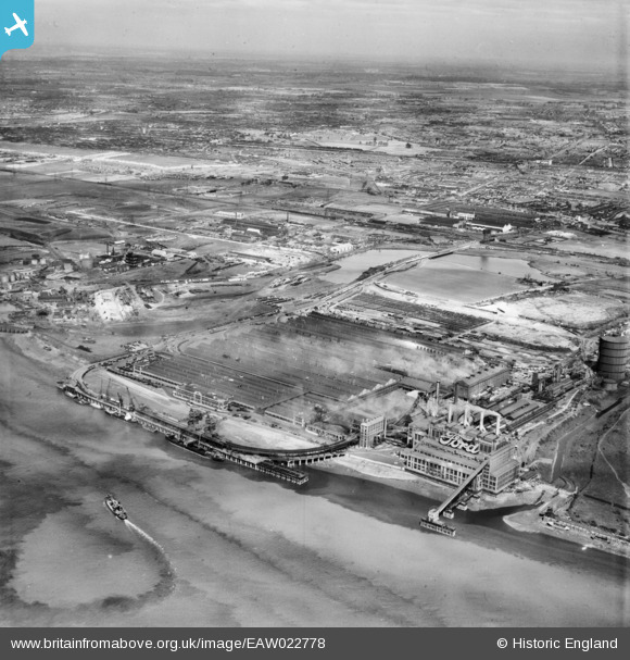
EAW022778 ENGLAND (1949). The Ford Motor Company Works, Dagenham, from the south-east, 1949
© Copyright OpenStreetMap contributors and licensed by the OpenStreetMap Foundation. 2026. Cartography is licensed as CC BY-SA.
Nearby Images (47)
EAW022778

EAW022770

EAW022769

EAW053050

EAW053039

EPW046934

EAW053041

EAW029512

EPW046927

EPW046931

EAW053047

EPW046920

EPW046930

EPW055258

EPW060998

EPW060996

EPW046925

EAW022766

EPW046917

EPW046933

EPW046924

EPW046932

EAW053043

EPW055193

EAW029508

EPW046937

EAW000071

EAW022765

EPW046916

EAW022772

EPW062034

EPW055199

EAW022771

EPW046926

EAW053042

EAW053203

EPW055197

EPW062035

EPW046918

EPW055149

EPW046921

EPW046922

EPW037317

EPW046923

EAW022768

EPW032052

EAW021712

Details
| Title | [EAW022778] The Ford Motor Company Works, Dagenham, from the south-east, 1949 |
| Reference | EAW022778 |
| Date | 29-April-1949 |
| Link | |
| Place name | DAGENHAM |
| Parish | |
| District | |
| Country | ENGLAND |
| Easting / Northing | 549647, 181419 |
| Longitude / Latitude | 0.15675908891909, 51.511370319279 |
| National Grid Reference | TQ496814 |
Pins

Billy Turner |
Tuesday 14th of July 2015 07:31:20 PM | |

MB |
Sunday 29th of December 2013 03:36:48 PM |

User Comment Contributions
By 2006 the rail network and the coal-fired power station had gone, but the main buildings remained: en.wikipedia.org/wiki/Ford_Dagenham |
MB |
Sunday 29th of December 2013 03:40:52 PM |