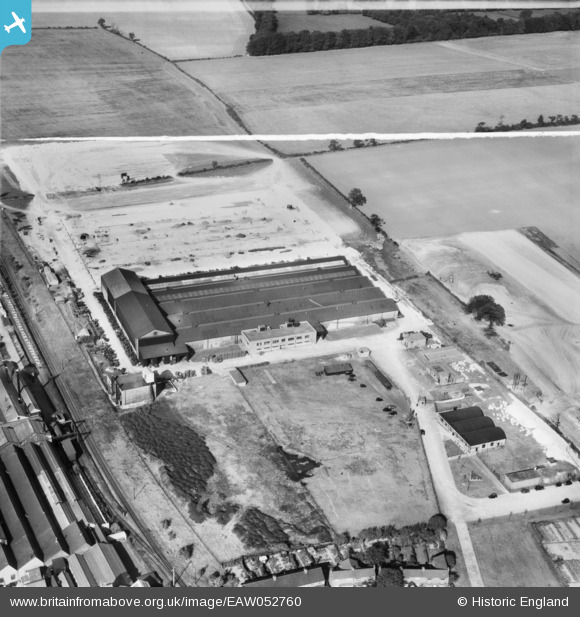
EAW052760 ENGLAND (1953). The Vauxhall (Bedford Truck) Dunstable Plant under construction, Dunstable, 1953. This image was marked by Aerofilms Ltd for photo editing.
© Copyright OpenStreetMap contributors and licensed by the OpenStreetMap Foundation. 2026. Cartography is licensed as CC BY-SA.
Nearby Images (11)
Details
| Title | [EAW052760] The Vauxhall (Bedford Truck) Dunstable Plant under construction, Dunstable, 1953. This image was marked by Aerofilms Ltd for photo editing. |
| Reference | EAW052760 |
| Date | 9-October-1953 |
| Link | |
| Place name | DUNSTABLE |
| Parish | DUNSTABLE |
| District | |
| Country | ENGLAND |
| Easting / Northing | 502497, 222282 |
| Longitude / Latitude | -0.51046535642955, 51.889219528615 |
| National Grid Reference | TL025223 |
Pins

Matt Aldred edob.mattaldred.com |
Thursday 7th of March 2024 05:12:24 PM | |

Matt Aldred edob.mattaldred.com |
Thursday 7th of March 2024 05:12:12 PM |


![[EAW052760] The Vauxhall (Bedford Truck) Dunstable Plant under construction, Dunstable, 1953. This image was marked by Aerofilms Ltd for photo editing.](http://britainfromabove.org.uk/sites/all/libraries/aerofilms-images/public/100x100/EAW/052/EAW052760.jpg)
![[EAW052758] The Vauxhall (Bedford Truck) Dunstable Plant under construction, Dunstable, 1953. This image was marked by Aerofilms Ltd for photo editing.](http://britainfromabove.org.uk/sites/all/libraries/aerofilms-images/public/100x100/EAW/052/EAW052758.jpg)
![[EAW052757] The Vauxhall (Bedford Truck) Dunstable Plant under construction, Dunstable, 1953. This image was marked by Aerofilms Ltd for photo editing.](http://britainfromabove.org.uk/sites/all/libraries/aerofilms-images/public/100x100/EAW/052/EAW052757.jpg)
![[EAW052763] The Vauxhall (Bedford Truck) Dunstable Plant, Dunstable under construction, 1953](http://britainfromabove.org.uk/sites/all/libraries/aerofilms-images/public/100x100/EAW/052/EAW052763.jpg)
![[EAW052755] The Vauxhall (Bedford Truck) Dunstable Plant under construction, Dunstable, 1953. This image was marked by Aerofilms Ltd for photo editing.](http://britainfromabove.org.uk/sites/all/libraries/aerofilms-images/public/100x100/EAW/052/EAW052755.jpg)
![[EAW052761] The Vauxhall (Bedford Truck) Dunstable Plant under construction and environs, Dunstable, 1953](http://britainfromabove.org.uk/sites/all/libraries/aerofilms-images/public/100x100/EAW/052/EAW052761.jpg)
![[EAW052764] The Vauxhall (Bedford Truck) Dunstable Plant under construction, Dunstable, 1953. This image was marked by Aerofilms Ltd for photo editing.](http://britainfromabove.org.uk/sites/all/libraries/aerofilms-images/public/100x100/EAW/052/EAW052764.jpg)
![[EAW052765] The Vauxhall (Bedford Truck) Dunstable Plant under construction, Dunstable, 1953](http://britainfromabove.org.uk/sites/all/libraries/aerofilms-images/public/100x100/EAW/052/EAW052765.jpg)
![[EAW052762] The Vauxhall (Bedford Truck) Dunstable Plant under construction, Dunstable, 1953](http://britainfromabove.org.uk/sites/all/libraries/aerofilms-images/public/100x100/EAW/052/EAW052762.jpg)
![[EAW052759] The Vauxhall (Bedford Truck) Dunstable Plant under construction, Dunstable, 1953. This image was marked by Aerofilms Ltd for photo editing.](http://britainfromabove.org.uk/sites/all/libraries/aerofilms-images/public/100x100/EAW/052/EAW052759.jpg)
![[EAW052756] The Vauxhall (Bedford Truck) Dunstable Plant under construction, Dunstable, 1953. This image was marked by Aerofilms Ltd for photo editing.](http://britainfromabove.org.uk/sites/all/libraries/aerofilms-images/public/100x100/EAW/052/EAW052756.jpg)