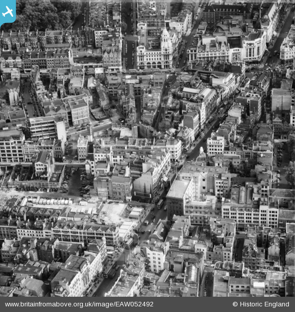
EAW052492 ENGLAND (1953). Oxford Street to the west of St Giles' Circus, Westminster, 1953
© Copyright OpenStreetMap contributors and licensed by the OpenStreetMap Foundation. 2026. Cartography is licensed as CC BY-SA.
Nearby Images (20)
Details
| Title | [EAW052492] Oxford Street to the west of St Giles' Circus, Westminster, 1953 |
| Reference | EAW052492 |
| Date | 30-September-1953 |
| Link | |
| Place name | WESTMINSTER |
| Parish | |
| District | |
| Country | ENGLAND |
| Easting / Northing | 529635, 181391 |
| Longitude / Latitude | -0.13149266554885, 51.516065791959 |
| National Grid Reference | TQ296814 |


![[EAW052492] Oxford Street to the west of St Giles' Circus, Westminster, 1953](http://britainfromabove.org.uk/sites/all/libraries/aerofilms-images/public/100x100/EAW/052/EAW052492.jpg)
![[EAW052491] Oxford Street to the west of St Giles' Circus, Westminster, 1953](http://britainfromabove.org.uk/sites/all/libraries/aerofilms-images/public/100x100/EAW/052/EAW052491.jpg)
![[EAW050855] Oxford Street from Bourne and Hollingsworth Department Store to St Giles' Circus, Westminster, 1953](http://britainfromabove.org.uk/sites/all/libraries/aerofilms-images/public/100x100/EAW/050/EAW050855.jpg)
![[EAW050835] Oxford Street from St Giles' Circus to Oxford Circus, Westminster, 1953](http://britainfromabove.org.uk/sites/all/libraries/aerofilms-images/public/100x100/EAW/050/EAW050835.jpg)
![[EAW050858] Oxford Street and St Giles' Circus, Westminster, 1953](http://britainfromabove.org.uk/sites/all/libraries/aerofilms-images/public/100x100/EAW/050/EAW050858.jpg)
![[EAW050862] Oxford Street from Bourne and Hollingsworth Department Store to Rathbone Place, Westminster, 1953](http://britainfromabove.org.uk/sites/all/libraries/aerofilms-images/public/100x100/EAW/050/EAW050862.jpg)
![[EAW050857] Oxford Street and St Giles' Circus, Westminster, 1953](http://britainfromabove.org.uk/sites/all/libraries/aerofilms-images/public/100x100/EAW/050/EAW050857.jpg)
![[EAW052493] Oxford Street at St Giles' Circus, Westminster, 1953](http://britainfromabove.org.uk/sites/all/libraries/aerofilms-images/public/100x100/EAW/052/EAW052493.jpg)
![[EAW050848] Oxford Street and Tottenham Court Road, Bloomsbury, 1953](http://britainfromabove.org.uk/sites/all/libraries/aerofilms-images/public/100x100/EAW/050/EAW050848.jpg)
![[EAW050842] Oxford Street, Wardour Street and environs, Westminster, 1953](http://britainfromabove.org.uk/sites/all/libraries/aerofilms-images/public/100x100/EAW/050/EAW050842.jpg)
![[EPW006168] The interchange of Charing Cross Road and Oxford Street, Soho, from the north-east, 1921](http://britainfromabove.org.uk/sites/all/libraries/aerofilms-images/public/100x100/EPW/006/EPW006168.jpg)
![[EAW041947] St Giles' Circus, Bloomsbury, 1952](http://britainfromabove.org.uk/sites/all/libraries/aerofilms-images/public/100x100/EAW/041/EAW041947.jpg)
![[EAW018341] Tottenham Court Road and Bedford Square, Bloomsbury, 1948. This image has been produced from a print.](http://britainfromabove.org.uk/sites/all/libraries/aerofilms-images/public/100x100/EAW/018/EAW018341.jpg)
![[EAW050834] Oxford Street, St Giles' Circus and New Oxford Street, Bloomsbury, 1953](http://britainfromabove.org.uk/sites/all/libraries/aerofilms-images/public/100x100/EAW/050/EAW050834.jpg)
![[EAW041943] St Giles' Circus, Bedford Square and the British Museum, Bloomsbury, 1952](http://britainfromabove.org.uk/sites/all/libraries/aerofilms-images/public/100x100/EAW/041/EAW041943.jpg)
![[EAW041948] St Giles' Circus, Bedford Square and the British Museum, Bloomsbury, 1952](http://britainfromabove.org.uk/sites/all/libraries/aerofilms-images/public/100x100/EAW/041/EAW041948.jpg)
![[EAW050851] Oxford Street including Bourne and Hollingsworth Department Store, Westminster, 1953](http://britainfromabove.org.uk/sites/all/libraries/aerofilms-images/public/100x100/EAW/050/EAW050851.jpg)
![[EAW041949] St Giles' Circus and Bedford Square, Bloomsbury, 1952](http://britainfromabove.org.uk/sites/all/libraries/aerofilms-images/public/100x100/EAW/041/EAW041949.jpg)
![[EAW050860] Oxford Street including Bourne and Hollingsworth Department Store, Westminster, 1953](http://britainfromabove.org.uk/sites/all/libraries/aerofilms-images/public/100x100/EAW/050/EAW050860.jpg)
![[EPW012737] The Middlesex Hospital and environs, Marylebone, 1925](http://britainfromabove.org.uk/sites/all/libraries/aerofilms-images/public/100x100/EPW/012/EPW012737.jpg)
