
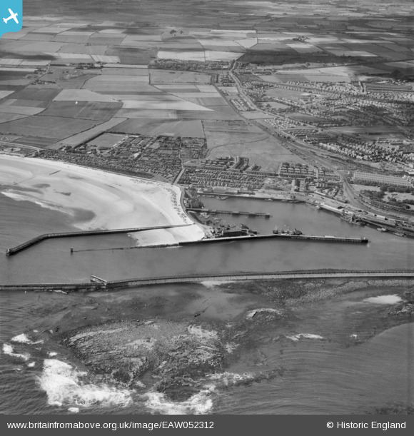
EAW052312 ENGLAND (1953). The South Harbour and environs, Blyth, 1953
© Copyright OpenStreetMap contributors and licensed by the OpenStreetMap Foundation. 2026. Cartography is licensed as CC BY-SA.
Nearby Images (6)
EAW052312

EPW019753

EPW019751

EPW048821

EPW048836

EPW019746

Details
| Title | [EAW052312] The South Harbour and environs, Blyth, 1953 |
| Reference | EAW052312 |
| Date | 10-September-1953 |
| Link | |
| Place name | BLYTH |
| Parish | BLYTH |
| District | |
| Country | ENGLAND |
| Easting / Northing | 432251, 580599 |
| Longitude / Latitude | -1.4942855126923, 55.118671707515 |
| National Grid Reference | NZ323806 |
Pins

Matt Aldred edob.mattaldred.com |
Sunday 7th of March 2021 02:33:10 PM | |
|
Matt Aldred edob.mattaldred.com |
Sunday 7th of March 2021 02:31:44 PM | |

redmist |
Tuesday 5th of January 2021 07:53:49 PM | |
|
redmist |
Tuesday 5th of January 2021 07:47:13 PM | |
|
redmist |
Tuesday 5th of January 2021 07:45:08 PM | |
|
redmist |
Tuesday 5th of January 2021 07:38:21 PM | |
|
redmist |
Tuesday 5th of November 2019 12:08:28 AM | |
|
redmist |
Tuesday 5th of November 2019 12:07:44 AM | |
|
redmist |
Tuesday 5th of November 2019 12:06:58 AM | |
|
cptpies |
Friday 1st of November 2019 09:40:51 AM | |
|
jrussill |
Tuesday 2nd of December 2014 06:25:44 PM | |
|
jrussill |
Tuesday 2nd of December 2014 06:22:12 PM |
User Comment Contributions
WW2 EXTENDED DEFENCE OFFICERS POST |
jrussill |
Tuesday 2nd of December 2014 06:23:03 PM |