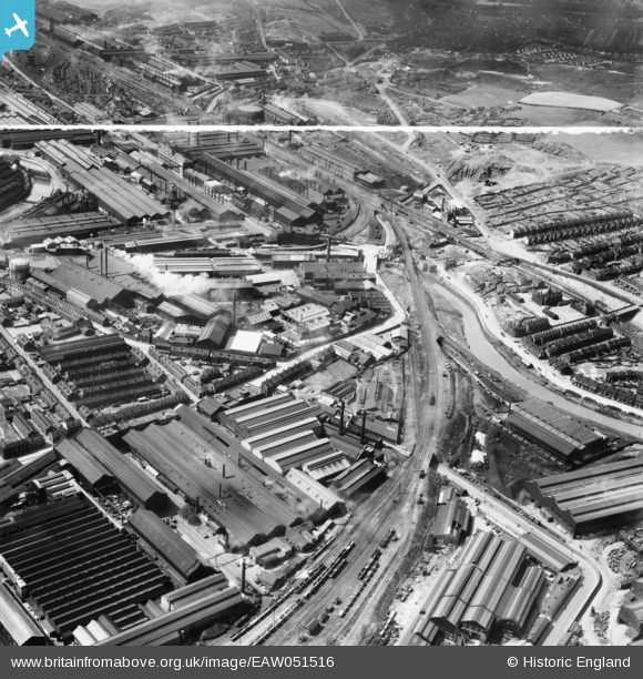
EAW051516 ENGLAND (1953). The Brightside Works and environs, Sheffield, 1953. This image was marked by Aerofilms Ltd for photo editing.
© Copyright OpenStreetMap contributors and licensed by the OpenStreetMap Foundation. 2026. Cartography is licensed as CC BY-SA.
Nearby Images (20)
Details
| Title | [EAW051516] The Brightside Works and environs, Sheffield, 1953. This image was marked by Aerofilms Ltd for photo editing. |
| Reference | EAW051516 |
| Date | 14-August-1953 |
| Link | |
| Place name | SHEFFIELD |
| Parish | |
| District | |
| Country | ENGLAND |
| Easting / Northing | 438726, 390452 |
| Longitude / Latitude | -1.4173686525762, 53.409198712051 |
| National Grid Reference | SK387905 |
Pins

circloy |
Sunday 13th of May 2018 11:32:22 PM | |

circloy |
Sunday 13th of May 2018 11:29:41 PM | |

circloy |
Sunday 13th of May 2018 11:28:50 PM | |

circloy |
Sunday 13th of May 2018 11:27:54 PM | |

circloy |
Sunday 13th of May 2018 11:27:08 PM | |

circloy |
Sunday 13th of May 2018 11:26:17 PM | |

circloy |
Sunday 13th of May 2018 11:25:16 PM | |

circloy |
Sunday 13th of May 2018 11:24:25 PM | |

circloy |
Sunday 13th of May 2018 11:23:38 PM | |

circloy |
Sunday 13th of May 2018 11:23:05 PM | |

circloy |
Sunday 13th of May 2018 11:22:04 PM | |

cat631 |
Saturday 17th of September 2016 12:12:18 AM | |

cat631 |
Saturday 17th of September 2016 12:12:16 AM |


![[EAW051516] The Brightside Works and environs, Sheffield, 1953. This image was marked by Aerofilms Ltd for photo editing.](http://britainfromabove.org.uk/sites/all/libraries/aerofilms-images/public/100x100/EAW/051/EAW051516.jpg)
![[EAW051514] The Brightside Works and environs, Sheffield, 1953. This image was marked by Aerofilms Ltd for photo editing.](http://britainfromabove.org.uk/sites/all/libraries/aerofilms-images/public/100x100/EAW/051/EAW051514.jpg)
![[EAW051520] The Brightside Works and environs, Sheffield, 1953. This image was marked by Aerofilms Ltd for photo editing.](http://britainfromabove.org.uk/sites/all/libraries/aerofilms-images/public/100x100/EAW/051/EAW051520.jpg)
![[EAW044232] The William Jessop and Sons Brightside Steel Works off Weedon Street, Sheffield, 1952](http://britainfromabove.org.uk/sites/all/libraries/aerofilms-images/public/100x100/EAW/044/EAW044232.jpg)
![[EAW051512] The Brightside Works and environs, Sheffield, 1953. This image was marked by Aerofilms Ltd for photo editing.](http://britainfromabove.org.uk/sites/all/libraries/aerofilms-images/public/100x100/EAW/051/EAW051512.jpg)
![[EAW044233] The William Jessop and Sons Brightside Steel Works and the surrounding area, Sheffield, from the north, 1952](http://britainfromabove.org.uk/sites/all/libraries/aerofilms-images/public/100x100/EAW/044/EAW044233.jpg)
![[EAW044235] The William Jessop and Sons Brightside Steel Works off Weedon Street, Sheffield, 1952. This image was marked by Aerofilms Ltd for photo editing.](http://britainfromabove.org.uk/sites/all/libraries/aerofilms-images/public/100x100/EAW/044/EAW044235.jpg)
![[EAW051518] The Brightside Works, River Don Works and environs, Sheffield, 1953. This image was marked by Aerofilms Ltd for photo editing.](http://britainfromabove.org.uk/sites/all/libraries/aerofilms-images/public/100x100/EAW/051/EAW051518.jpg)
![[EAW051515] The Brightside Works and environs, Sheffield, 1953. This image was marked by Aerofilms Ltd for photo editing.](http://britainfromabove.org.uk/sites/all/libraries/aerofilms-images/public/100x100/EAW/051/EAW051515.jpg)
![[EAW051519] The Brightside Works, River Don Works and environs, Sheffield, 1953. This image was marked by Aerofilms Ltd for photo editing.](http://britainfromabove.org.uk/sites/all/libraries/aerofilms-images/public/100x100/EAW/051/EAW051519.jpg)
![[EPW007787] The Brightside Works and environs, Sheffield, 1922](http://britainfromabove.org.uk/sites/all/libraries/aerofilms-images/public/100x100/EPW/007/EPW007787.jpg)
![[EAW051513] The Brightside Works and environs, Sheffield, 1953. This image was marked by Aerofilms Ltd for photo editing.](http://britainfromabove.org.uk/sites/all/libraries/aerofilms-images/public/100x100/EAW/051/EAW051513.jpg)
![[EAW051517] The Brightside Works, River Don Works and environs, Sheffield, 1953. This image was marked by Aerofilms Ltd for photo editing.](http://britainfromabove.org.uk/sites/all/libraries/aerofilms-images/public/100x100/EAW/051/EAW051517.jpg)
![[EAW044229] The William Jessop and Sons Brightside Steel Works off Weedon Street, Sheffield, 1952](http://britainfromabove.org.uk/sites/all/libraries/aerofilms-images/public/100x100/EAW/044/EAW044229.jpg)
![[EPW007794] The Brightside Works, Sheffield, 1922](http://britainfromabove.org.uk/sites/all/libraries/aerofilms-images/public/100x100/EPW/007/EPW007794.jpg)
![[EAW044231] The William Jessop and Sons Brightside Steel Works off Weedon Street, Sheffield, 1952](http://britainfromabove.org.uk/sites/all/libraries/aerofilms-images/public/100x100/EAW/044/EAW044231.jpg)
![[EAW044234] The William Jessop and Sons Brightside Steel Works off Weedon Street, Sheffield, 1952. This image was marked by Aerofilms Ltd for photo editing.](http://britainfromabove.org.uk/sites/all/libraries/aerofilms-images/public/100x100/EAW/044/EAW044234.jpg)
![[EAW044230] The William Jessop and Sons Brightside Steel Works off Weedon Street, Sheffield, 1952](http://britainfromabove.org.uk/sites/all/libraries/aerofilms-images/public/100x100/EAW/044/EAW044230.jpg)
![[EAW044228] The William Jessop and Sons Brightside Steel Works off Weedon Street, Sheffield, 1952](http://britainfromabove.org.uk/sites/all/libraries/aerofilms-images/public/100x100/EAW/044/EAW044228.jpg)
![[EAW018799] The Staybrite Steel Works on Weedon Street and environs, Tinsley, 1948. This image was marked by Aerofilms Ltd for photo editing.](http://britainfromabove.org.uk/sites/all/libraries/aerofilms-images/public/100x100/EAW/018/EAW018799.jpg)