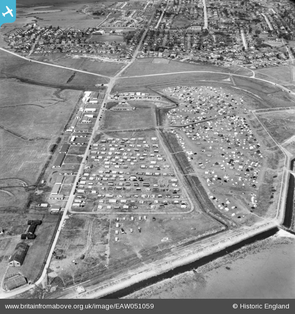
EAW051059 ENGLAND (1953). Thorney Bay Holiday Camp, Canvey Island, 1953
© Copyright OpenStreetMap contributors and licensed by the OpenStreetMap Foundation. 2026. Cartography is licensed as CC BY-SA.
Nearby Images (14)
Details
| Title | [EAW051059] Thorney Bay Holiday Camp, Canvey Island, 1953 |
| Reference | EAW051059 |
| Date | 3-August-1953 |
| Link | |
| Place name | CANVEY ISLAND |
| Parish | CANVEY ISLAND |
| District | |
| Country | ENGLAND |
| Easting / Northing | 579258, 182457 |
| Longitude / Latitude | 0.58362170747283, 51.51207693851 |
| National Grid Reference | TQ793825 |
Pins

redmist |
Saturday 28th of January 2023 10:47:08 PM | |

redmist |
Saturday 28th of January 2023 10:43:37 PM | |

redmist |
Saturday 28th of January 2023 10:40:17 PM | |

redmist |
Saturday 28th of January 2023 10:39:47 PM |


![[EAW051059] Thorney Bay Holiday Camp, Canvey Island, 1953](http://britainfromabove.org.uk/sites/all/libraries/aerofilms-images/public/100x100/EAW/051/EAW051059.jpg)
![[EAW045319] Thorney Bay Camp, Canvey Island, 1952](http://britainfromabove.org.uk/sites/all/libraries/aerofilms-images/public/100x100/EAW/045/EAW045319.jpg)
![[EAW051062] Thorney Bay Holiday Camp, Canvey Island, 1953](http://britainfromabove.org.uk/sites/all/libraries/aerofilms-images/public/100x100/EAW/051/EAW051062.jpg)
![[EAW051061] Thorney Bay Holiday Camp, Canvey Island, 1953](http://britainfromabove.org.uk/sites/all/libraries/aerofilms-images/public/100x100/EAW/051/EAW051061.jpg)
![[EAW026914] Thorney Bay and the surrounding residential area, Canvey Island, 1949](http://britainfromabove.org.uk/sites/all/libraries/aerofilms-images/public/100x100/EAW/026/EAW026914.jpg)
![[EAW051060] Thorney Bay Holiday Camp and environs, Canvey Island, 1953](http://britainfromabove.org.uk/sites/all/libraries/aerofilms-images/public/100x100/EAW/051/EAW051060.jpg)
![[EAW045320] Thorney Bay Camp, Canvey Island, 1952](http://britainfromabove.org.uk/sites/all/libraries/aerofilms-images/public/100x100/EAW/045/EAW045320.jpg)
![[EAW051063] Thorney Bay Holiday Camp, Canvey Island, 1953](http://britainfromabove.org.uk/sites/all/libraries/aerofilms-images/public/100x100/EAW/051/EAW051063.jpg)
![[EAW045318] Thorney Bay Camp and environs, Canvey Island, 1952](http://britainfromabove.org.uk/sites/all/libraries/aerofilms-images/public/100x100/EAW/045/EAW045318.jpg)
![[EAW051019] Thorney Bay Holiday Camp, Canvey Island, 1953](http://britainfromabove.org.uk/sites/all/libraries/aerofilms-images/public/100x100/EAW/051/EAW051019.jpg)
![[EAW045335] Thorney Bay Camp and the town, Canvey Island, 1952](http://britainfromabove.org.uk/sites/all/libraries/aerofilms-images/public/100x100/EAW/045/EAW045335.jpg)
![[EAW051017] Thorney Bay, Canvey Island, 1953](http://britainfromabove.org.uk/sites/all/libraries/aerofilms-images/public/100x100/EAW/051/EAW051017.jpg)
![[EAW051018] Dead Man's Battery at Deadman's Point, Canvey Island, 1953](http://britainfromabove.org.uk/sites/all/libraries/aerofilms-images/public/100x100/EAW/051/EAW051018.jpg)
![[EAW026913] Deadman's Point, Canvey Island, 1949](http://britainfromabove.org.uk/sites/all/libraries/aerofilms-images/public/100x100/EAW/026/EAW026913.jpg)