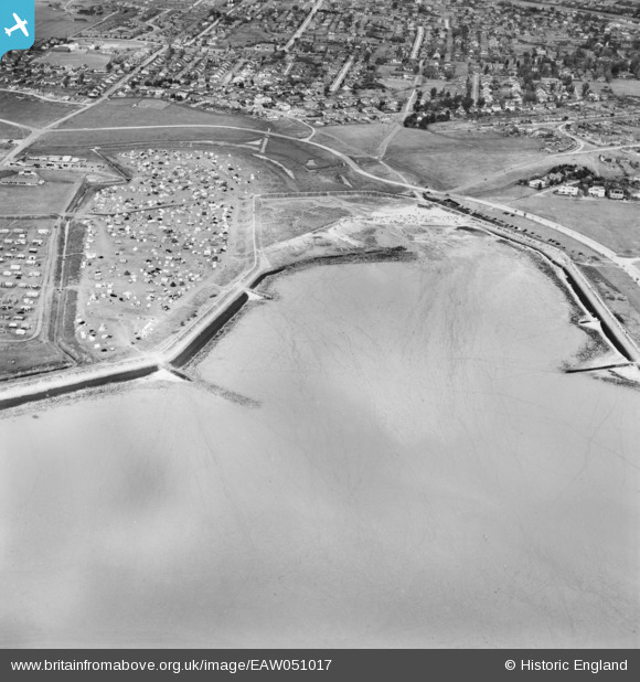
EAW051017 ENGLAND (1953). Thorney Bay, Canvey Island, 1953
© Copyright OpenStreetMap contributors and licensed by the OpenStreetMap Foundation. 2026. Cartography is licensed as CC BY-SA.
Nearby Images (15)
Details
| Title | [EAW051017] Thorney Bay, Canvey Island, 1953 |
| Reference | EAW051017 |
| Date | 3-August-1953 |
| Link | |
| Place name | CANVEY ISLAND |
| Parish | CANVEY ISLAND |
| District | |
| Country | ENGLAND |
| Easting / Northing | 579482, 182399 |
| Longitude / Latitude | 0.58681712294157, 51.511484788881 |
| National Grid Reference | TQ795824 |
Pins

redmist |
Friday 21st of January 2022 12:52:26 PM |


![[EAW051017] Thorney Bay, Canvey Island, 1953](http://britainfromabove.org.uk/sites/all/libraries/aerofilms-images/public/100x100/EAW/051/EAW051017.jpg)
![[EAW045321] Thorney Bay, Canvey Island, 1952](http://britainfromabove.org.uk/sites/all/libraries/aerofilms-images/public/100x100/EAW/045/EAW045321.jpg)
![[EAW045320] Thorney Bay Camp, Canvey Island, 1952](http://britainfromabove.org.uk/sites/all/libraries/aerofilms-images/public/100x100/EAW/045/EAW045320.jpg)
![[EAW045322] Thorney Bay, Canvey Island, 1952](http://britainfromabove.org.uk/sites/all/libraries/aerofilms-images/public/100x100/EAW/045/EAW045322.jpg)
![[EAW026915] Thorney Bay and the surrounding residential area, Canvey Island, 1949](http://britainfromabove.org.uk/sites/all/libraries/aerofilms-images/public/100x100/EAW/026/EAW026915.jpg)
![[EAW051061] Thorney Bay Holiday Camp, Canvey Island, 1953](http://britainfromabove.org.uk/sites/all/libraries/aerofilms-images/public/100x100/EAW/051/EAW051061.jpg)
![[EAW045335] Thorney Bay Camp and the town, Canvey Island, 1952](http://britainfromabove.org.uk/sites/all/libraries/aerofilms-images/public/100x100/EAW/045/EAW045335.jpg)
![[EAW051016] Thorney Bay, Canvey Island, 1953](http://britainfromabove.org.uk/sites/all/libraries/aerofilms-images/public/100x100/EAW/051/EAW051016.jpg)
![[EAW051062] Thorney Bay Holiday Camp, Canvey Island, 1953](http://britainfromabove.org.uk/sites/all/libraries/aerofilms-images/public/100x100/EAW/051/EAW051062.jpg)
![[EAW051019] Thorney Bay Holiday Camp, Canvey Island, 1953](http://britainfromabove.org.uk/sites/all/libraries/aerofilms-images/public/100x100/EAW/051/EAW051019.jpg)
![[EAW026914] Thorney Bay and the surrounding residential area, Canvey Island, 1949](http://britainfromabove.org.uk/sites/all/libraries/aerofilms-images/public/100x100/EAW/026/EAW026914.jpg)
![[EAW051059] Thorney Bay Holiday Camp, Canvey Island, 1953](http://britainfromabove.org.uk/sites/all/libraries/aerofilms-images/public/100x100/EAW/051/EAW051059.jpg)
![[EAW045323] Western Esplanade and the residential area around Cleveland Road, Canvey Island, 1952](http://britainfromabove.org.uk/sites/all/libraries/aerofilms-images/public/100x100/EAW/045/EAW045323.jpg)
![[EAW051063] Thorney Bay Holiday Camp, Canvey Island, 1953](http://britainfromabove.org.uk/sites/all/libraries/aerofilms-images/public/100x100/EAW/051/EAW051063.jpg)
![[EAW045319] Thorney Bay Camp, Canvey Island, 1952](http://britainfromabove.org.uk/sites/all/libraries/aerofilms-images/public/100x100/EAW/045/EAW045319.jpg)