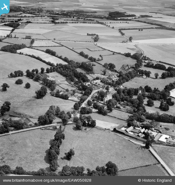
EAW050828 ENGLAND (1953). The village and surrounding countryside, Willian, 1953
© Copyright OpenStreetMap contributors and licensed by the OpenStreetMap Foundation. 2026. Cartography is licensed as CC BY-SA.
Nearby Images (17)
Details
| Title | [EAW050828] The village and surrounding countryside, Willian, 1953 |
| Reference | EAW050828 |
| Date | 21-July-1953 |
| Link | |
| Place name | WILLIAN |
| Parish | LETCHWORTH GARDEN CITY |
| District | |
| Country | ENGLAND |
| Easting / Northing | 522482, 230772 |
| Longitude / Latitude | -0.21715160664734, 51.961490069066 |
| National Grid Reference | TL225308 |
Pins

Roscoe |
Wednesday 12th of November 2014 08:57:33 PM | |

Roscoe |
Wednesday 12th of November 2014 08:56:46 PM | |

Roscoe |
Wednesday 12th of November 2014 08:56:06 PM | |

Roscoe |
Wednesday 12th of November 2014 08:55:12 PM | |

Roscoe |
Wednesday 12th of November 2014 08:54:29 PM |


![[EAW050828] The village and surrounding countryside, Willian, 1953](http://britainfromabove.org.uk/sites/all/libraries/aerofilms-images/public/100x100/EAW/050/EAW050828.jpg)
![[EAW050829] The village and surrounding countryside, Willian, 1953](http://britainfromabove.org.uk/sites/all/libraries/aerofilms-images/public/100x100/EAW/050/EAW050829.jpg)
![[EAW050817] The village, Willian, 1953](http://britainfromabove.org.uk/sites/all/libraries/aerofilms-images/public/100x100/EAW/050/EAW050817.jpg)
![[EAW050821] Punchardon Hall and environs, Willian, 1953](http://britainfromabove.org.uk/sites/all/libraries/aerofilms-images/public/100x100/EAW/050/EAW050821.jpg)
![[EAW050819] The village, Willian, 1953](http://britainfromabove.org.uk/sites/all/libraries/aerofilms-images/public/100x100/EAW/050/EAW050819.jpg)
![[EAW050830] The village, Willian, 1953](http://britainfromabove.org.uk/sites/all/libraries/aerofilms-images/public/100x100/EAW/050/EAW050830.jpg)
![[EAW050822] Punchardon Hall and environs, Willian, 1953](http://britainfromabove.org.uk/sites/all/libraries/aerofilms-images/public/100x100/EAW/050/EAW050822.jpg)
![[EAW050823] Punchardon Hall, Willian, 1953](http://britainfromabove.org.uk/sites/all/libraries/aerofilms-images/public/100x100/EAW/050/EAW050823.jpg)
![[EAW050825] The village, Willian, from the north-west, 1953](http://britainfromabove.org.uk/sites/all/libraries/aerofilms-images/public/100x100/EAW/050/EAW050825.jpg)
![[EAW050827] Punchardon Hall, Willian, 1953](http://britainfromabove.org.uk/sites/all/libraries/aerofilms-images/public/100x100/EAW/050/EAW050827.jpg)
![[EAW050820] Punchardon Hall and the Fox Inn, Willian, 1953](http://britainfromabove.org.uk/sites/all/libraries/aerofilms-images/public/100x100/EAW/050/EAW050820.jpg)
![[EAW050824] Punchardon Hall, Willian, 1953](http://britainfromabove.org.uk/sites/all/libraries/aerofilms-images/public/100x100/EAW/050/EAW050824.jpg)
![[EAW050818] Punchardon Hall, Willian, 1953](http://britainfromabove.org.uk/sites/all/libraries/aerofilms-images/public/100x100/EAW/050/EAW050818.jpg)
![[EAW050831] The village, Willian, 1953](http://britainfromabove.org.uk/sites/all/libraries/aerofilms-images/public/100x100/EAW/050/EAW050831.jpg)
![[EAW050826] Punchardon Hall, Willian, 1953](http://britainfromabove.org.uk/sites/all/libraries/aerofilms-images/public/100x100/EAW/050/EAW050826.jpg)
![[EAW050832] The village and surrounding countryside, Willian, 1953](http://britainfromabove.org.uk/sites/all/libraries/aerofilms-images/public/100x100/EAW/050/EAW050832.jpg)
![[EAW050833] The village and surrounding countryside, Willian, from the east, 1953](http://britainfromabove.org.uk/sites/all/libraries/aerofilms-images/public/100x100/EAW/050/EAW050833.jpg)