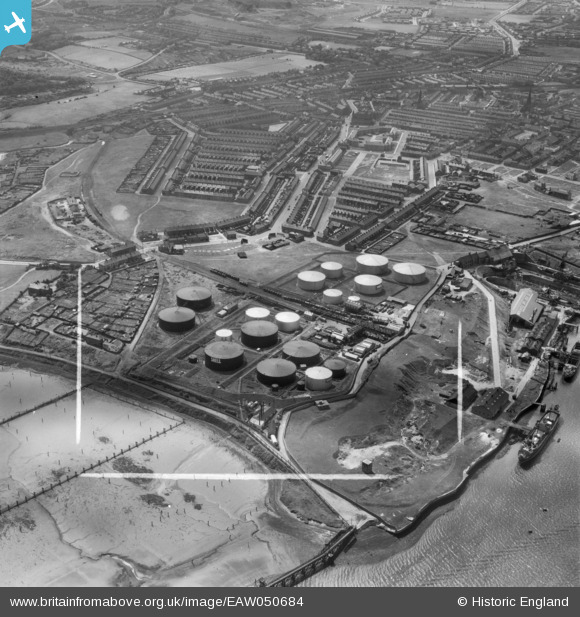
EAW050684 ENGLAND (1953). The Shell-Mex and BP Ltd Oil Depot and environs, Jarrow, 1953. This image was marked by Aerofilms Ltd for photo editing.
© Copyright OpenStreetMap contributors and licensed by the OpenStreetMap Foundation. 2026. Cartography is licensed as CC BY-SA.
Nearby Images (12)
Details
| Title | [EAW050684] The Shell-Mex and BP Ltd Oil Depot and environs, Jarrow, 1953. This image was marked by Aerofilms Ltd for photo editing. |
| Reference | EAW050684 |
| Date | 15-July-1953 |
| Link | |
| Place name | JARROW |
| Parish | |
| District | |
| Country | ENGLAND |
| Easting / Northing | 433608, 565580 |
| Longitude / Latitude | -1.4747774443465, 54.983609334345 |
| National Grid Reference | NZ336656 |
Pins

N Dunn |
Tuesday 16th of November 2021 02:44:54 PM | |

N Dunn |
Tuesday 16th of November 2021 02:42:42 PM | |

N Dunn |
Tuesday 16th of November 2021 02:41:51 PM | |

N Dunn |
Tuesday 16th of November 2021 02:40:47 PM | |

N Dunn |
Tuesday 16th of November 2021 02:39:34 PM | |

N Dunn |
Tuesday 16th of November 2021 02:37:35 PM | |

N Dunn |
Tuesday 16th of November 2021 02:35:18 PM | |

N Dunn |
Tuesday 16th of November 2021 02:34:15 PM | |

N Dunn |
Tuesday 16th of November 2021 02:33:05 PM | |

N Dunn |
Tuesday 16th of November 2021 02:28:40 PM | |

N Dunn |
Tuesday 14th of August 2018 03:17:32 PM |


![[EAW050684] The Shell-Mex and BP Ltd Oil Depot and environs, Jarrow, 1953. This image was marked by Aerofilms Ltd for photo editing.](http://britainfromabove.org.uk/sites/all/libraries/aerofilms-images/public/100x100/EAW/050/EAW050684.jpg)
![[EAW050682] The Shell-Mex and BP Ltd Oil Depot and environs, Jarrow, 1953. This image was marked by Aerofilms Ltd for photo editing.](http://britainfromabove.org.uk/sites/all/libraries/aerofilms-images/public/100x100/EAW/050/EAW050682.jpg)
![[EAW050675] The Shell-Mex and BP Ltd Oil Depot and environs, Jarrow, 1953. This image was marked by Aerofilms Ltd for photo editing.](http://britainfromabove.org.uk/sites/all/libraries/aerofilms-images/public/100x100/EAW/050/EAW050675.jpg)
![[EAW050678] The Shell-Mex and BP Ltd Oil Depot, Jarrow, 1953. This image was marked by Aerofilms Ltd for photo editing.](http://britainfromabove.org.uk/sites/all/libraries/aerofilms-images/public/100x100/EAW/050/EAW050678.jpg)
![[EAW050674] The Shell-Mex and BP Ltd Oil Depot and environs, Jarrow, 1953. This image was marked by Aerofilms Ltd for photo editing.](http://britainfromabove.org.uk/sites/all/libraries/aerofilms-images/public/100x100/EAW/050/EAW050674.jpg)
![[EAW050676] The Shell-Mex and BP Ltd Oil Depot and Jarrow Slake, Jarrow, 1953. This image was marked by Aerofilms Ltd for photo editing.](http://britainfromabove.org.uk/sites/all/libraries/aerofilms-images/public/100x100/EAW/050/EAW050676.jpg)
![[EAW050680] The Shell-Mex and BP Ltd Oil Depot and Jarrow Slake, Jarrow, 1953. This image was marked by Aerofilms Ltd for photo editing.](http://britainfromabove.org.uk/sites/all/libraries/aerofilms-images/public/100x100/EAW/050/EAW050680.jpg)
![[EAW050679] The Shell-Mex and BP Ltd Oil Depot and environs, Jarrow, 1953. This image was marked by Aerofilms Ltd for photo editing.](http://britainfromabove.org.uk/sites/all/libraries/aerofilms-images/public/100x100/EAW/050/EAW050679.jpg)
![[EAW050683] The Shell-Mex and BP Ltd Oil Depot and Northumberland Dock, Jarrow, 1953. This image was marked by Aerofilms Ltd for photo editing.](http://britainfromabove.org.uk/sites/all/libraries/aerofilms-images/public/100x100/EAW/050/EAW050683.jpg)
![[EAW050681] The Shell-Mex and BP Ltd Oil Depot and Jarrow Slake, Jarrow, 1953. This image was marked by Aerofilms Ltd for photo editing.](http://britainfromabove.org.uk/sites/all/libraries/aerofilms-images/public/100x100/EAW/050/EAW050681.jpg)
![[EPW012070] A British Petroleum Co Ltd oil depot, Jarrow, 1924. This image has been produced from a print.](http://britainfromabove.org.uk/sites/all/libraries/aerofilms-images/public/100x100/EPW/012/EPW012070.jpg)
![[EAW050685] The Shell-Mex and BP Ltd Oil Depot and Northumberland Dock, Jarrow, 1953. This image was marked by Aerofilms Ltd for photo editing.](http://britainfromabove.org.uk/sites/all/libraries/aerofilms-images/public/100x100/EAW/050/EAW050685.jpg)