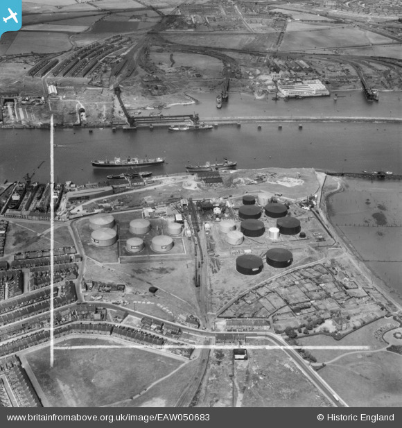
EAW050683 ENGLAND (1953). The Shell-Mex and BP Ltd Oil Depot and Northumberland Dock, Jarrow, 1953. This image was marked by Aerofilms Ltd for photo editing.
© Copyright OpenStreetMap contributors and licensed by the OpenStreetMap Foundation. 2026. Cartography is licensed as CC BY-SA.
Nearby Images (13)
Details
| Title | [EAW050683] The Shell-Mex and BP Ltd Oil Depot and Northumberland Dock, Jarrow, 1953. This image was marked by Aerofilms Ltd for photo editing. |
| Reference | EAW050683 |
| Date | 15-July-1953 |
| Link | |
| Place name | JARROW |
| Parish | |
| District | |
| Country | ENGLAND |
| Easting / Northing | 433618, 565692 |
| Longitude / Latitude | -1.474608027913, 54.98461518837 |
| National Grid Reference | NZ336657 |
Pins

redmist |
Tuesday 29th of October 2019 09:04:21 AM | |

redmist |
Monday 28th of October 2019 10:53:42 PM | |

redmist |
Monday 28th of October 2019 10:48:11 PM | |

N Dunn |
Tuesday 14th of August 2018 03:12:56 PM |


![[EAW050683] The Shell-Mex and BP Ltd Oil Depot and Northumberland Dock, Jarrow, 1953. This image was marked by Aerofilms Ltd for photo editing.](http://britainfromabove.org.uk/sites/all/libraries/aerofilms-images/public/100x100/EAW/050/EAW050683.jpg)
![[EPW012070] A British Petroleum Co Ltd oil depot, Jarrow, 1924. This image has been produced from a print.](http://britainfromabove.org.uk/sites/all/libraries/aerofilms-images/public/100x100/EPW/012/EPW012070.jpg)
![[EAW050676] The Shell-Mex and BP Ltd Oil Depot and Jarrow Slake, Jarrow, 1953. This image was marked by Aerofilms Ltd for photo editing.](http://britainfromabove.org.uk/sites/all/libraries/aerofilms-images/public/100x100/EAW/050/EAW050676.jpg)
![[EAW050680] The Shell-Mex and BP Ltd Oil Depot and Jarrow Slake, Jarrow, 1953. This image was marked by Aerofilms Ltd for photo editing.](http://britainfromabove.org.uk/sites/all/libraries/aerofilms-images/public/100x100/EAW/050/EAW050680.jpg)
![[EAW050678] The Shell-Mex and BP Ltd Oil Depot, Jarrow, 1953. This image was marked by Aerofilms Ltd for photo editing.](http://britainfromabove.org.uk/sites/all/libraries/aerofilms-images/public/100x100/EAW/050/EAW050678.jpg)
![[EAW050681] The Shell-Mex and BP Ltd Oil Depot and Jarrow Slake, Jarrow, 1953. This image was marked by Aerofilms Ltd for photo editing.](http://britainfromabove.org.uk/sites/all/libraries/aerofilms-images/public/100x100/EAW/050/EAW050681.jpg)
![[EAW050679] The Shell-Mex and BP Ltd Oil Depot and environs, Jarrow, 1953. This image was marked by Aerofilms Ltd for photo editing.](http://britainfromabove.org.uk/sites/all/libraries/aerofilms-images/public/100x100/EAW/050/EAW050679.jpg)
![[EAW050684] The Shell-Mex and BP Ltd Oil Depot and environs, Jarrow, 1953. This image was marked by Aerofilms Ltd for photo editing.](http://britainfromabove.org.uk/sites/all/libraries/aerofilms-images/public/100x100/EAW/050/EAW050684.jpg)
![[EAW050675] The Shell-Mex and BP Ltd Oil Depot and environs, Jarrow, 1953. This image was marked by Aerofilms Ltd for photo editing.](http://britainfromabove.org.uk/sites/all/libraries/aerofilms-images/public/100x100/EAW/050/EAW050675.jpg)
![[EAW050682] The Shell-Mex and BP Ltd Oil Depot and environs, Jarrow, 1953. This image was marked by Aerofilms Ltd for photo editing.](http://britainfromabove.org.uk/sites/all/libraries/aerofilms-images/public/100x100/EAW/050/EAW050682.jpg)
![[EAW050677] The Shell-Mex and BP Ltd Oil Depot and Northumberland Dock, Jarrow, 1953. This image was marked by Aerofilms Ltd for photo editing.](http://britainfromabove.org.uk/sites/all/libraries/aerofilms-images/public/100x100/EAW/050/EAW050677.jpg)
![[EAW050674] The Shell-Mex and BP Ltd Oil Depot and environs, Jarrow, 1953. This image was marked by Aerofilms Ltd for photo editing.](http://britainfromabove.org.uk/sites/all/libraries/aerofilms-images/public/100x100/EAW/050/EAW050674.jpg)
![[EAW050685] The Shell-Mex and BP Ltd Oil Depot and Northumberland Dock, Jarrow, 1953. This image was marked by Aerofilms Ltd for photo editing.](http://britainfromabove.org.uk/sites/all/libraries/aerofilms-images/public/100x100/EAW/050/EAW050685.jpg)