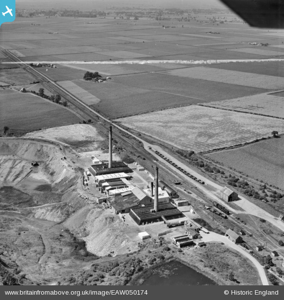
EAW050174 ENGLAND (1953). Warboys Brick Works and Wistow Fen, Warboys, from the south, 1953. This image was marked by Aerofilms Ltd for photo editing.
© Copyright OpenStreetMap contributors and licensed by the OpenStreetMap Foundation. 2026. Cartography is licensed as CC BY-SA.
Nearby Images (8)
Details
| Title | [EAW050174] Warboys Brick Works and Wistow Fen, Warboys, from the south, 1953. This image was marked by Aerofilms Ltd for photo editing. |
| Reference | EAW050174 |
| Date | 26-June-1953 |
| Link | |
| Place name | WARBOYS |
| Parish | WARBOYS |
| District | |
| Country | ENGLAND |
| Easting / Northing | 531090, 281773 |
| Longitude / Latitude | -0.072197943680225, 52.41784283091 |
| National Grid Reference | TL311818 |
Pins
Be the first to add a comment to this image!


![[EAW050174] Warboys Brick Works and Wistow Fen, Warboys, from the south, 1953. This image was marked by Aerofilms Ltd for photo editing.](http://britainfromabove.org.uk/sites/all/libraries/aerofilms-images/public/100x100/EAW/050/EAW050174.jpg)
![[EAW050177] Warboys Brick Works and Warboys Railway Station, Warboys, 1953. This image was marked by Aerofilms Ltd for photo editing.](http://britainfromabove.org.uk/sites/all/libraries/aerofilms-images/public/100x100/EAW/050/EAW050177.jpg)
![[EAW050173] Warboys Brick Works, Warboys, 1953. This image was marked by Aerofilms Ltd for photo editing.](http://britainfromabove.org.uk/sites/all/libraries/aerofilms-images/public/100x100/EAW/050/EAW050173.jpg)
![[EAW050171] Warboys Brick Works, Warboys, 1953. This image was marked by Aerofilms Ltd for photo editing.](http://britainfromabove.org.uk/sites/all/libraries/aerofilms-images/public/100x100/EAW/050/EAW050171.jpg)
![[EAW050176] Warboys Brick Works, Warboys, 1953. This image was marked by Aerofilms Ltd for photo editing.](http://britainfromabove.org.uk/sites/all/libraries/aerofilms-images/public/100x100/EAW/050/EAW050176.jpg)
![[EAW050175] Warboys Brick Works and Puddock Road, Warboys, from the south-west, 1953. This image was marked by Aerofilms Ltd for photo editing.](http://britainfromabove.org.uk/sites/all/libraries/aerofilms-images/public/100x100/EAW/050/EAW050175.jpg)
![[EAW050178] Warboys Brick Works, Warboys, 1953. This image was marked by Aerofilms Ltd for photo editing.](http://britainfromabove.org.uk/sites/all/libraries/aerofilms-images/public/100x100/EAW/050/EAW050178.jpg)
![[EAW050172] Warboys Brick Works, Warboys, 1953. This image was marked by Aerofilms Ltd for photo editing.](http://britainfromabove.org.uk/sites/all/libraries/aerofilms-images/public/100x100/EAW/050/EAW050172.jpg)