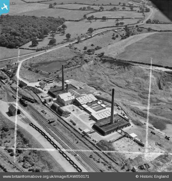
EAW050171 ENGLAND (1953). Warboys Brick Works, Warboys, 1953. This image was marked by Aerofilms Ltd for photo editing.
© Copyright OpenStreetMap contributors and licensed by the OpenStreetMap Foundation. 2026. Cartography is licensed as CC BY-SA.
Nearby Images (8)
Details
| Title | [EAW050171] Warboys Brick Works, Warboys, 1953. This image was marked by Aerofilms Ltd for photo editing. |
| Reference | EAW050171 |
| Date | 26-June-1953 |
| Link | |
| Place name | WARBOYS |
| Parish | WARBOYS |
| District | |
| Country | ENGLAND |
| Easting / Northing | 531072, 281744 |
| Longitude / Latitude | -0.072473855176833, 52.417586550825 |
| National Grid Reference | TL311817 |
Pins
Be the first to add a comment to this image!
User Comment Contributions
Work at this site now...Almost nothing in this photo exists anymore...totally different! |

burnsy111183 |
Tuesday 12th of August 2014 08:28:03 PM |


![[EAW050171] Warboys Brick Works, Warboys, 1953. This image was marked by Aerofilms Ltd for photo editing.](http://britainfromabove.org.uk/sites/all/libraries/aerofilms-images/public/100x100/EAW/050/EAW050171.jpg)
![[EAW050173] Warboys Brick Works, Warboys, 1953. This image was marked by Aerofilms Ltd for photo editing.](http://britainfromabove.org.uk/sites/all/libraries/aerofilms-images/public/100x100/EAW/050/EAW050173.jpg)
![[EAW050174] Warboys Brick Works and Wistow Fen, Warboys, from the south, 1953. This image was marked by Aerofilms Ltd for photo editing.](http://britainfromabove.org.uk/sites/all/libraries/aerofilms-images/public/100x100/EAW/050/EAW050174.jpg)
![[EAW050178] Warboys Brick Works, Warboys, 1953. This image was marked by Aerofilms Ltd for photo editing.](http://britainfromabove.org.uk/sites/all/libraries/aerofilms-images/public/100x100/EAW/050/EAW050178.jpg)
![[EAW050177] Warboys Brick Works and Warboys Railway Station, Warboys, 1953. This image was marked by Aerofilms Ltd for photo editing.](http://britainfromabove.org.uk/sites/all/libraries/aerofilms-images/public/100x100/EAW/050/EAW050177.jpg)
![[EAW050176] Warboys Brick Works, Warboys, 1953. This image was marked by Aerofilms Ltd for photo editing.](http://britainfromabove.org.uk/sites/all/libraries/aerofilms-images/public/100x100/EAW/050/EAW050176.jpg)
![[EAW050175] Warboys Brick Works and Puddock Road, Warboys, from the south-west, 1953. This image was marked by Aerofilms Ltd for photo editing.](http://britainfromabove.org.uk/sites/all/libraries/aerofilms-images/public/100x100/EAW/050/EAW050175.jpg)
![[EAW050172] Warboys Brick Works, Warboys, 1953. This image was marked by Aerofilms Ltd for photo editing.](http://britainfromabove.org.uk/sites/all/libraries/aerofilms-images/public/100x100/EAW/050/EAW050172.jpg)