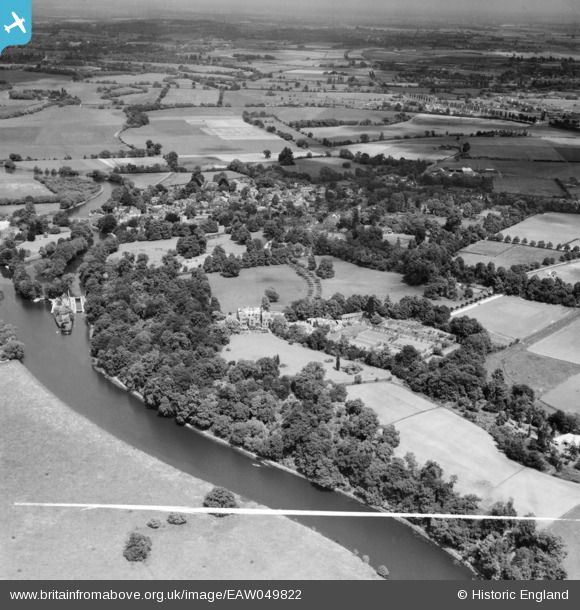
EAW049822 ENGLAND (1953). Reading Blue Coat School, Sonning, from the south-west, 1953. This image was marked by Aerofilms Ltd for photo editing.
© Copyright OpenStreetMap contributors and licensed by the OpenStreetMap Foundation. 2026. Cartography is licensed as CC BY-SA.
Nearby Images (14)
Details
| Title | [EAW049822] Reading Blue Coat School, Sonning, from the south-west, 1953. This image was marked by Aerofilms Ltd for photo editing. |
| Reference | EAW049822 |
| Date | 6-June-1953 |
| Link | |
| Place name | SONNING |
| Parish | SONNING |
| District | |
| Country | ENGLAND |
| Easting / Northing | 475089, 175092 |
| Longitude / Latitude | -0.91883213934245, 51.46931969536 |
| National Grid Reference | SU751751 |
Pins

designking |
Saturday 13th of September 2014 11:29:39 PM |


![[EAW049822] Reading Blue Coat School, Sonning, from the south-west, 1953. This image was marked by Aerofilms Ltd for photo editing.](http://britainfromabove.org.uk/sites/all/libraries/aerofilms-images/public/100x100/EAW/049/EAW049822.jpg)
![[EPW032649] Holme Park, Sonning, 1930](http://britainfromabove.org.uk/sites/all/libraries/aerofilms-images/public/100x100/EPW/032/EPW032649.jpg)
![[EPW032650] Holme Park, Sonning, 1930](http://britainfromabove.org.uk/sites/all/libraries/aerofilms-images/public/100x100/EPW/032/EPW032650.jpg)
![[EPW032648] Holme Park, Sonning, 1930](http://britainfromabove.org.uk/sites/all/libraries/aerofilms-images/public/100x100/EPW/032/EPW032648.jpg)
![[EAW049821] Reading Blue Coat School, Sonning, 1953. This image was marked by Aerofilms Ltd for photo editing.](http://britainfromabove.org.uk/sites/all/libraries/aerofilms-images/public/100x100/EAW/049/EAW049821.jpg)
![[EAW049820] Reading Blue Coat School, Sonning, 1953. This image was marked by Aerofilms Ltd for photo editing.](http://britainfromabove.org.uk/sites/all/libraries/aerofilms-images/public/100x100/EAW/049/EAW049820.jpg)
![[EPW032652] Holme Park, Sonning, 1930](http://britainfromabove.org.uk/sites/all/libraries/aerofilms-images/public/100x100/EPW/032/EPW032652.jpg)
![[EPW032661] Holme Park, Sonning, 1930](http://britainfromabove.org.uk/sites/all/libraries/aerofilms-images/public/100x100/EPW/032/EPW032661.jpg)
![[EAW049823] Reading Blue Coat School, Sonning, 1953](http://britainfromabove.org.uk/sites/all/libraries/aerofilms-images/public/100x100/EAW/049/EAW049823.jpg)
![[EAW049819] Reading Blue Coat School, Sonning, 1953. This image was marked by Aerofilms Ltd for photo editing.](http://britainfromabove.org.uk/sites/all/libraries/aerofilms-images/public/100x100/EAW/049/EAW049819.jpg)
![[EPW032651] Holme Park, Sonning, 1930](http://britainfromabove.org.uk/sites/all/libraries/aerofilms-images/public/100x100/EPW/032/EPW032651.jpg)
![[EPW032647] Holme Park, Sonning, 1930](http://britainfromabove.org.uk/sites/all/libraries/aerofilms-images/public/100x100/EPW/032/EPW032647.jpg)
![[EAW049824] Reading Blue Coat School, Sonning, 1953. This image was marked by Aerofilms Ltd for photo editing.](http://britainfromabove.org.uk/sites/all/libraries/aerofilms-images/public/100x100/EAW/049/EAW049824.jpg)
![[EAW049825] Reading Blue Coat School, Sonning, 1953. This image was marked by Aerofilms Ltd for photo editing.](http://britainfromabove.org.uk/sites/all/libraries/aerofilms-images/public/100x100/EAW/049/EAW049825.jpg)