
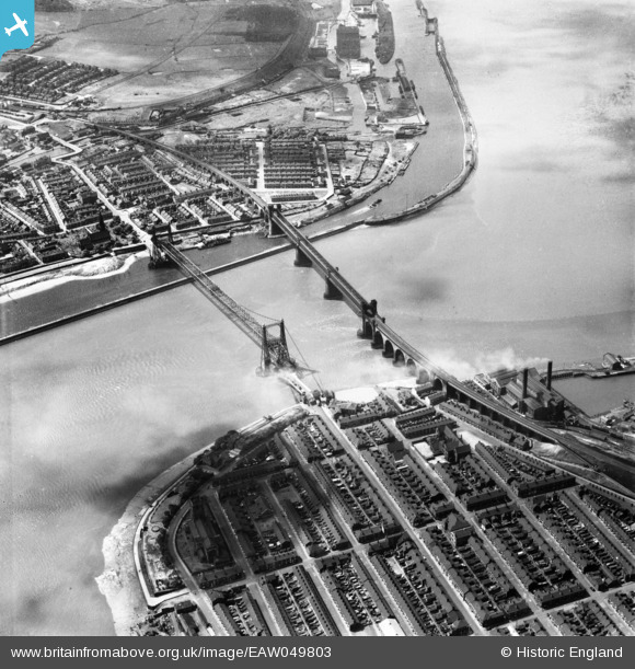
EAW049803 ENGLAND (1953). The Widnes Transporter Bridge and Runcorn Railway Bridge crossing the River Mersey and Manchester Ship Canal, Runcorn Gap, 1953
© Copyright OpenStreetMap contributors and licensed by the OpenStreetMap Foundation. 2026. Cartography is licensed as CC BY-SA.
Nearby Images (34)
EAW049803

EAW049806

EAW049798

EAW044938

EAW049816

EAW044943

EAW049801

EAW044942

EPW005875

EAW049812

EAW008431

EAW049814

EAW049818

EAW005675

EAW049807

EAW044937

EAW044940

EAW005676

EAW008430

EAW049815

EAW044941

EAW049799

EPW018913

EAW049813

EAW049808

EAW049804

EAW049800

EAW049809

EAW049817

EPW014298

EAW044939

EAW049797

EAW049802

EAW049805

Details
| Title | [EAW049803] The Widnes Transporter Bridge and Runcorn Railway Bridge crossing the River Mersey and Manchester Ship Canal, Runcorn Gap, 1953 |
| Reference | EAW049803 |
| Date | 30-May-1953 |
| Link | |
| Place name | RUNCORN GAP |
| Parish | |
| District | |
| Country | ENGLAND |
| Easting / Northing | 350958, 383534 |
| Longitude / Latitude | -2.7367485088804, 53.346155504526 |
| National Grid Reference | SJ510835 |
Pins

Ginger79 |
Friday 25th of June 2021 05:41:58 PM | |
|
Ginger79 |
Saturday 2nd of May 2020 11:39:42 PM | |
|
Ginger79 |
Wednesday 23rd of October 2019 04:19:48 PM | |
|
Ginger79 |
Wednesday 23rd of October 2019 04:16:25 PM | |
|
Ginger79 |
Wednesday 23rd of October 2019 04:15:28 PM | |
|
Ginger79 |
Tuesday 16th of July 2019 12:54:37 AM | |

Bottom Yard |
Friday 28th of December 2018 04:35:07 PM | |
|
Bottom Yard |
Friday 28th of December 2018 04:34:12 PM |
