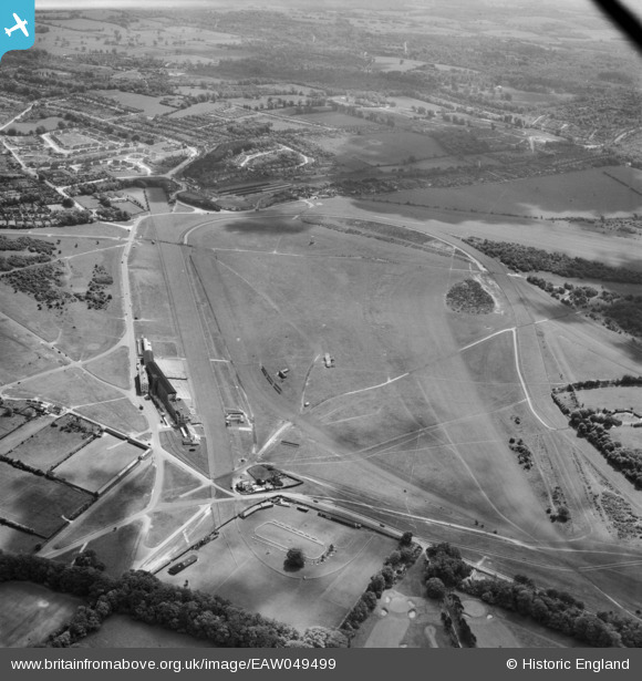
EAW049499 ENGLAND (1953). Epsom Downs Racecourse, Epsom, 1953
© Copyright OpenStreetMap contributors and licensed by the OpenStreetMap Foundation. 2026. Cartography is licensed as CC BY-SA.
Nearby Images (28)
Details
| Title | [EAW049499] Epsom Downs Racecourse, Epsom, 1953 |
| Reference | EAW049499 |
| Date | 19-May-1953 |
| Link | |
| Place name | EPSOM |
| Parish | |
| District | |
| Country | ENGLAND |
| Easting / Northing | 521894, 158226 |
| Longitude / Latitude | -0.25097599490775, 51.309572600907 |
| National Grid Reference | TQ219582 |
Pins
Be the first to add a comment to this image!


![[EAW049499] Epsom Downs Racecourse, Epsom, 1953](http://britainfromabove.org.uk/sites/all/libraries/aerofilms-images/public/100x100/EAW/049/EAW049499.jpg)
![[EPW006387] Epsom Racecourse, Epsom Downs, 1921](http://britainfromabove.org.uk/sites/all/libraries/aerofilms-images/public/100x100/EPW/006/EPW006387.jpg)
![[EAW024759] Epsom Racecourse, Epsom Downs, 1949](http://britainfromabove.org.uk/sites/all/libraries/aerofilms-images/public/100x100/EAW/024/EAW024759.jpg)
![[EPW006391] Epsom Downs, Derby Day at Epsom Racecourse, 1921. This image has been produced from a print.](http://britainfromabove.org.uk/sites/all/libraries/aerofilms-images/public/100x100/EPW/006/EPW006391.jpg)
![[EAW017627] Fairground at Epsom Racecourse, Epsom Downs, 1948. This image has been produced from a print.](http://britainfromabove.org.uk/sites/all/libraries/aerofilms-images/public/100x100/EAW/017/EAW017627.jpg)
![[EAW002166] Epsom Downs, The City and Surburban Race Meeting, 1946](http://britainfromabove.org.uk/sites/all/libraries/aerofilms-images/public/100x100/EAW/002/EAW002166.jpg)
![[EAW002165] Epsom Downs, The City and Surburban Race Meeting, from the north-east, 1946](http://britainfromabove.org.uk/sites/all/libraries/aerofilms-images/public/100x100/EAW/002/EAW002165.jpg)
![[EAW000996] Epsom Downs, crowds at the Epsom Race Course Victory Derby, from the south, 1946. This image has been produced from a damaged negative.](http://britainfromabove.org.uk/sites/all/libraries/aerofilms-images/public/100x100/EAW/000/EAW000996.jpg)
![[EAW002167] Epsom Downs, The City and Surburban Race Meeting, from the north, 1946](http://britainfromabove.org.uk/sites/all/libraries/aerofilms-images/public/100x100/EAW/002/EAW002167.jpg)
![[EAW000997] Epsom Downs, crowds at the Epsom Race Course Victory Derby, from the south, 1946. This image has been produced from a damaged negative.](http://britainfromabove.org.uk/sites/all/libraries/aerofilms-images/public/100x100/EAW/000/EAW000997.jpg)
![[EPW025147] The Epsom Downs Race Course and Grand Stand, Epsom Downs, from the south-east, 1928](http://britainfromabove.org.uk/sites/all/libraries/aerofilms-images/public/100x100/EPW/025/EPW025147.jpg)
![[EAW000991] Epsom Downs, crowds at the Epsom Race Course Victory Derby, from the south, 1946. This image has been produced from a damaged negative.](http://britainfromabove.org.uk/sites/all/libraries/aerofilms-images/public/100x100/EAW/000/EAW000991.jpg)
![[EAW043433] Epsom Downs, Derby Day at Epsom Racecourse, 1952](http://britainfromabove.org.uk/sites/all/libraries/aerofilms-images/public/100x100/EAW/043/EAW043433.jpg)
![[EPW027457] Epsom Downs, Derby Day, 1929](http://britainfromabove.org.uk/sites/all/libraries/aerofilms-images/public/100x100/EPW/027/EPW027457.jpg)
![[EAW017626] Racecourse tents and the Grandstand at Epsom Racecourse, Epsom Downs, 1948. This image has been produced from a print.](http://britainfromabove.org.uk/sites/all/libraries/aerofilms-images/public/100x100/EAW/017/EAW017626.jpg)
![[EPW007653] The Home Straight at Epsom Racecourse, Epsom, from the east, 1922](http://britainfromabove.org.uk/sites/all/libraries/aerofilms-images/public/100x100/EPW/007/EPW007653.jpg)
![[EPW006369] Epsom Racecourse, Epsom Downs, 1921](http://britainfromabove.org.uk/sites/all/libraries/aerofilms-images/public/100x100/EPW/006/EPW006369.jpg)
![[EPW006380] Epsom Racecourse, Epsom Downs, 1921](http://britainfromabove.org.uk/sites/all/libraries/aerofilms-images/public/100x100/EPW/006/EPW006380.jpg)
![[EPW035515] Epsom Downs, Derby Day, 1931](http://britainfromabove.org.uk/sites/all/libraries/aerofilms-images/public/100x100/EPW/035/EPW035515.jpg)
![[EPW006441] Epsom Racecourse on Derby Day, Epsom Downs, 1921](http://britainfromabove.org.uk/sites/all/libraries/aerofilms-images/public/100x100/EPW/006/EPW006441.jpg)
![[EPW006431] Epsom Downs, Derby Day crowds at Epsom Racecourse, 1921. This image has been produced from a print.](http://britainfromabove.org.uk/sites/all/libraries/aerofilms-images/public/100x100/EPW/006/EPW006431.jpg)
![[EPW006382] Epsom Racecourse, Epsom Downs, from the east, 1921](http://britainfromabove.org.uk/sites/all/libraries/aerofilms-images/public/100x100/EPW/006/EPW006382.jpg)
![[EPW006363] Epsom Racecourse, Epsom Downs, from the south-east, 1921](http://britainfromabove.org.uk/sites/all/libraries/aerofilms-images/public/100x100/EPW/006/EPW006363.jpg)
![[EPW008663] Temporary booths for race day, Epsom, 1923](http://britainfromabove.org.uk/sites/all/libraries/aerofilms-images/public/100x100/EPW/008/EPW008663.jpg)
![[EPW027459] Epsom Downs, Derby Day, 1929](http://britainfromabove.org.uk/sites/all/libraries/aerofilms-images/public/100x100/EPW/027/EPW027459.jpg)
![[EPW006364] Epsom Racecourse, Epsom Downs, from the north-east, 1921](http://britainfromabove.org.uk/sites/all/libraries/aerofilms-images/public/100x100/EPW/006/EPW006364.jpg)
![[EPW007900] Epsom Racecourse, Epsom Downs, 1922](http://britainfromabove.org.uk/sites/all/libraries/aerofilms-images/public/100x100/EPW/007/EPW007900.jpg)
![[EAW000995] Epsom Downs, crowds at the Epsom Race Course Victory Derby, from the south, 1946. This image has been produced from a damaged negative.](http://britainfromabove.org.uk/sites/all/libraries/aerofilms-images/public/100x100/EAW/000/EAW000995.jpg)