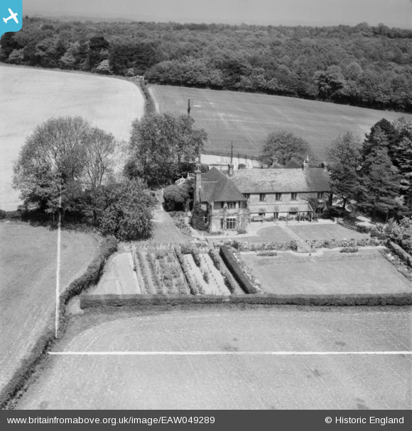
EAW049289 ENGLAND (1953). Hookland Farm, Awbrook, 1953. This image was marked by Aerofilms Ltd for photo editing.
© Copyright OpenStreetMap contributors and licensed by the OpenStreetMap Foundation. 2024. Cartography is licensed as CC BY-SA.
Nearby Images (6)
Details
| Title | [EAW049289] Hookland Farm, Awbrook, 1953. This image was marked by Aerofilms Ltd for photo editing. |
| Reference | EAW049289 |
| Date | 13-May-1953 |
| Link | |
| Place name | AWBROOK |
| Parish | LINDFIELD RURAL |
| District | |
| Country | ENGLAND |
| Easting / Northing | 536390, 122243 |
| Longitude / Latitude | -0.056732737910441, 50.982873152867 |
| National Grid Reference | TQ364222 |
Pins
Be the first to add a comment to this image!


![[EAW049289] Hookland Farm, Awbrook, 1953. This image was marked by Aerofilms Ltd for photo editing.](http://britainfromabove.org.uk/sites/all/libraries/aerofilms-images/public/100x100/EAW/049/EAW049289.jpg)
![[EAW049290] Hookland Farm, Awbrook, 1953. This image was marked by Aerofilms Ltd for photo editing.](http://britainfromabove.org.uk/sites/all/libraries/aerofilms-images/public/100x100/EAW/049/EAW049290.jpg)
![[EAW044413] Hookland Farm at Scaynes Hill, Walstead, 1952. This image was marked by Aerofilms Ltd for photo editing.](http://britainfromabove.org.uk/sites/all/libraries/aerofilms-images/public/100x100/EAW/044/EAW044413.jpg)
![[EAW044414] Hookland Farm at Scaynes Hill, Walstead, 1952. This image was marked by Aerofilms Ltd for photo editing.](http://britainfromabove.org.uk/sites/all/libraries/aerofilms-images/public/100x100/EAW/044/EAW044414.jpg)
![[EAW044416] Hookland Farm at Scaynes Hill, Walstead, 1952. This image was marked by Aerofilms Ltd for photo editing.](http://britainfromabove.org.uk/sites/all/libraries/aerofilms-images/public/100x100/EAW/044/EAW044416.jpg)
![[EAW044415] Hookland Farm at Scaynes Hill, Walstead, 1952. This image was marked by Aerofilms Ltd for photo editing.](http://britainfromabove.org.uk/sites/all/libraries/aerofilms-images/public/100x100/EAW/044/EAW044415.jpg)