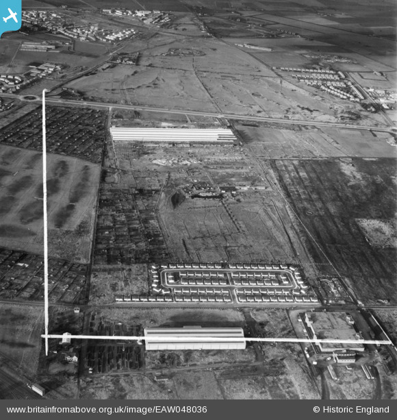
EAW048036 ENGLAND (1952). Housing at Bridle Avenue alongside the English Electric Co Works under construction, Netherton, 1952. This image was marked by Aerofilms Ltd for photo editing.
© Copyright OpenStreetMap contributors and licensed by the OpenStreetMap Foundation. 2025. Cartography is licensed as CC BY-SA.
Nearby Images (5)
Details
| Title | [EAW048036] Housing at Bridle Avenue alongside the English Electric Co Works under construction, Netherton, 1952. This image was marked by Aerofilms Ltd for photo editing. |
| Reference | EAW048036 |
| Date | 12-December-1952 |
| Link | |
| Place name | NETHERTON |
| Parish | |
| District | |
| Country | ENGLAND |
| Easting / Northing | 335759, 397923 |
| Longitude / Latitude | -2.9679807785802, 53.473860591068 |
| National Grid Reference | SJ358979 |
Pins

rivermersey |
Tuesday 16th of August 2022 01:12:22 PM | |

tiv |
Thursday 24th of November 2016 11:29:17 AM | |

bootle kid |
Friday 29th of August 2014 03:28:35 PM | |

rivermersey |
Friday 11th of July 2014 02:09:42 AM | |

rivermersey |
Friday 11th of July 2014 02:07:31 AM | |

john |
Friday 4th of July 2014 03:02:56 PM | |

john |
Friday 4th of July 2014 03:00:53 PM | |

john |
Friday 4th of July 2014 02:54:38 PM | |

john |
Friday 4th of July 2014 02:51:08 PM | |

john |
Friday 4th of July 2014 02:48:17 PM | |

john |
Friday 4th of July 2014 02:27:09 PM | |

john |
Friday 4th of July 2014 02:24:26 PM | |

john |
Friday 4th of July 2014 02:23:29 PM | |

john |
Friday 4th of July 2014 02:22:17 PM | |

john |
Friday 4th of July 2014 02:18:28 PM | |
was this house once a Vicarage? |

john |
Friday 4th of July 2014 06:34:38 PM |

john |
Friday 4th of July 2014 02:12:31 PM | |

john |
Friday 4th of July 2014 02:09:46 PM | |

john |
Friday 4th of July 2014 02:06:48 PM | |

john |
Friday 4th of July 2014 02:04:53 PM | |

john |
Friday 4th of July 2014 02:02:35 PM | |

john |
Friday 4th of July 2014 02:00:30 PM | |
found this info from a website called http://www.knowhere.co.uk/Netherton/Merseyside/Northern-England/messages?start=2 by jeff bagnall (Member 10232937) on 1-Nov-2008 The "corpy yard" was originally a working farm until the war. It was owmed by a family called ?Musker. The field behind the farm was later to house Netherton Moss Infant/Juniors And later the Boys Grammar School. A german aircraft was shot down into that field and narrowly missed hitting the the vicarage which was then the last house on the left in Bridge Lane. I vaguely remember Miss Hicks - she was friendly with my mother, I called but don't remember getting sweets. |

john |
Friday 4th of July 2014 06:33:32 PM |

john |
Friday 4th of July 2014 01:53:15 PM | |

Daveowe |
Thursday 3rd of July 2014 09:41:33 PM | |

Daveowe |
Thursday 3rd of July 2014 09:39:31 PM | |

john |
Thursday 3rd of July 2014 03:39:50 PM | |

john |
Thursday 3rd of July 2014 03:37:52 PM | |
St Oswald's was consecrated in 1961 - a fine example of modern design. Unfortunately the hi-tech concrete used did not survive very long. - hence the move to Ronald Ross Ave. |

David Evans |
Saturday 2nd of August 2014 04:54:42 PM |


![[EAW048036] Housing at Bridle Avenue alongside the English Electric Co Works under construction, Netherton, 1952. This image was marked by Aerofilms Ltd for photo editing.](http://britainfromabove.org.uk/sites/all/libraries/aerofilms-images/public/100x100/EAW/048/EAW048036.jpg)
![[EAW048032] Housing at Bridle Avenue alongside the English Electric Co Works under construction, Netherton, 1952. This image was marked by Aerofilms Ltd for photo editing.](http://britainfromabove.org.uk/sites/all/libraries/aerofilms-images/public/100x100/EAW/048/EAW048032.jpg)
![[EAW048040] Housing at Bridle Avenue alongside the English Electric Co Works under construction, Netherton, 1952. This image was marked by Aerofilms Ltd for photo editing.](http://britainfromabove.org.uk/sites/all/libraries/aerofilms-images/public/100x100/EAW/048/EAW048040.jpg)
![[EAW048039] Housing at Bridle Avenue alongside the English Electric Co Works under construction, Netherton, 1952. This image was marked by Aerofilms Ltd for photo editing.](http://britainfromabove.org.uk/sites/all/libraries/aerofilms-images/public/100x100/EAW/048/EAW048039.jpg)
![[EAW048033] The English Electric Co Works under construction off Dunnings Bridge Road, Netherton, 1952. This image was marked by Aerofilms Ltd for photo editing.](http://britainfromabove.org.uk/sites/all/libraries/aerofilms-images/public/100x100/EAW/048/EAW048033.jpg)