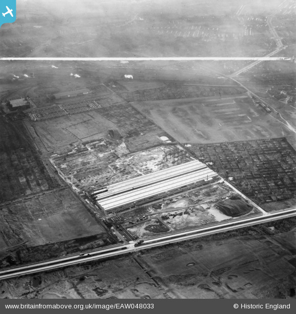
EAW048033 ENGLAND (1952). The English Electric Co Works under construction off Dunnings Bridge Road, Netherton, 1952. This image was marked by Aerofilms Ltd for photo editing.
© Copyright OpenStreetMap contributors and licensed by the OpenStreetMap Foundation. 2025. Cartography is licensed as CC BY-SA.
Nearby Images (11)
Details
| Title | [EAW048033] The English Electric Co Works under construction off Dunnings Bridge Road, Netherton, 1952. This image was marked by Aerofilms Ltd for photo editing. |
| Reference | EAW048033 |
| Date | 12-December-1952 |
| Link | |
| Place name | NETHERTON |
| Parish | |
| District | |
| Country | ENGLAND |
| Easting / Northing | 335517, 398042 |
| Longitude / Latitude | -2.9716510844175, 53.474900599121 |
| National Grid Reference | SJ355980 |
Pins

rivermersey |
Tuesday 16th of August 2022 01:08:51 PM | |

rivermersey |
Saturday 25th of June 2016 11:43:16 AM | |

rivermersey |
Saturday 25th of June 2016 11:41:11 AM | |

rivermersey |
Saturday 25th of June 2016 11:39:25 AM | |

rivermersey |
Saturday 25th of June 2016 11:37:10 AM | |

rivermersey |
Saturday 25th of June 2016 11:35:02 AM | |
Was this originally the site of 'reserved' tracks for the trams in this area? |

John W |
Wednesday 20th of July 2016 04:55:05 PM |


![[EAW048033] The English Electric Co Works under construction off Dunnings Bridge Road, Netherton, 1952. This image was marked by Aerofilms Ltd for photo editing.](http://britainfromabove.org.uk/sites/all/libraries/aerofilms-images/public/100x100/EAW/048/EAW048033.jpg)
![[EAW048037] The English Electric Co Works under construction off Dunnings Bridge Road, Netherton, 1952. This image was marked by Aerofilms Ltd for photo editing.](http://britainfromabove.org.uk/sites/all/libraries/aerofilms-images/public/100x100/EAW/048/EAW048037.jpg)
![[EAW048041] The English Electric Co Works under construction off Dunnings Bridge Road, Netherton, 1952. This image was marked by Aerofilms Ltd for photo editing.](http://britainfromabove.org.uk/sites/all/libraries/aerofilms-images/public/100x100/EAW/048/EAW048041.jpg)
![[EAW048038] The English Electric Co Works under construction off Dunnings Bridge Road, Netherton, 1952. This image was marked by Aerofilms Ltd for photo editing.](http://britainfromabove.org.uk/sites/all/libraries/aerofilms-images/public/100x100/EAW/048/EAW048038.jpg)
![[EAW048031] The English Electric Co Works under construction off Dunnings Bridge Road, Netherton, 1952. This image was marked by Aerofilms Ltd for photo editing.](http://britainfromabove.org.uk/sites/all/libraries/aerofilms-images/public/100x100/EAW/048/EAW048031.jpg)
![[EAW048035] The English Electric Co Works under construction off Dunnings Bridge Road, Netherton, 1952. This image was marked by Aerofilms Ltd for photo editing.](http://britainfromabove.org.uk/sites/all/libraries/aerofilms-images/public/100x100/EAW/048/EAW048035.jpg)
![[EAW048034] The English Electric Co Works under construction off Dunnings Bridge Road, Netherton, 1952. This image was marked by Aerofilms Ltd for photo editing.](http://britainfromabove.org.uk/sites/all/libraries/aerofilms-images/public/100x100/EAW/048/EAW048034.jpg)
![[EAW048030] The English Electric Co Works under construction off Dunnings Bridge Road, Netherton, 1952. This image was marked by Aerofilms Ltd for photo editing.](http://britainfromabove.org.uk/sites/all/libraries/aerofilms-images/public/100x100/EAW/048/EAW048030.jpg)
![[EAW048040] Housing at Bridle Avenue alongside the English Electric Co Works under construction, Netherton, 1952. This image was marked by Aerofilms Ltd for photo editing.](http://britainfromabove.org.uk/sites/all/libraries/aerofilms-images/public/100x100/EAW/048/EAW048040.jpg)
![[EAW048032] Housing at Bridle Avenue alongside the English Electric Co Works under construction, Netherton, 1952. This image was marked by Aerofilms Ltd for photo editing.](http://britainfromabove.org.uk/sites/all/libraries/aerofilms-images/public/100x100/EAW/048/EAW048032.jpg)
![[EAW048036] Housing at Bridle Avenue alongside the English Electric Co Works under construction, Netherton, 1952. This image was marked by Aerofilms Ltd for photo editing.](http://britainfromabove.org.uk/sites/all/libraries/aerofilms-images/public/100x100/EAW/048/EAW048036.jpg)